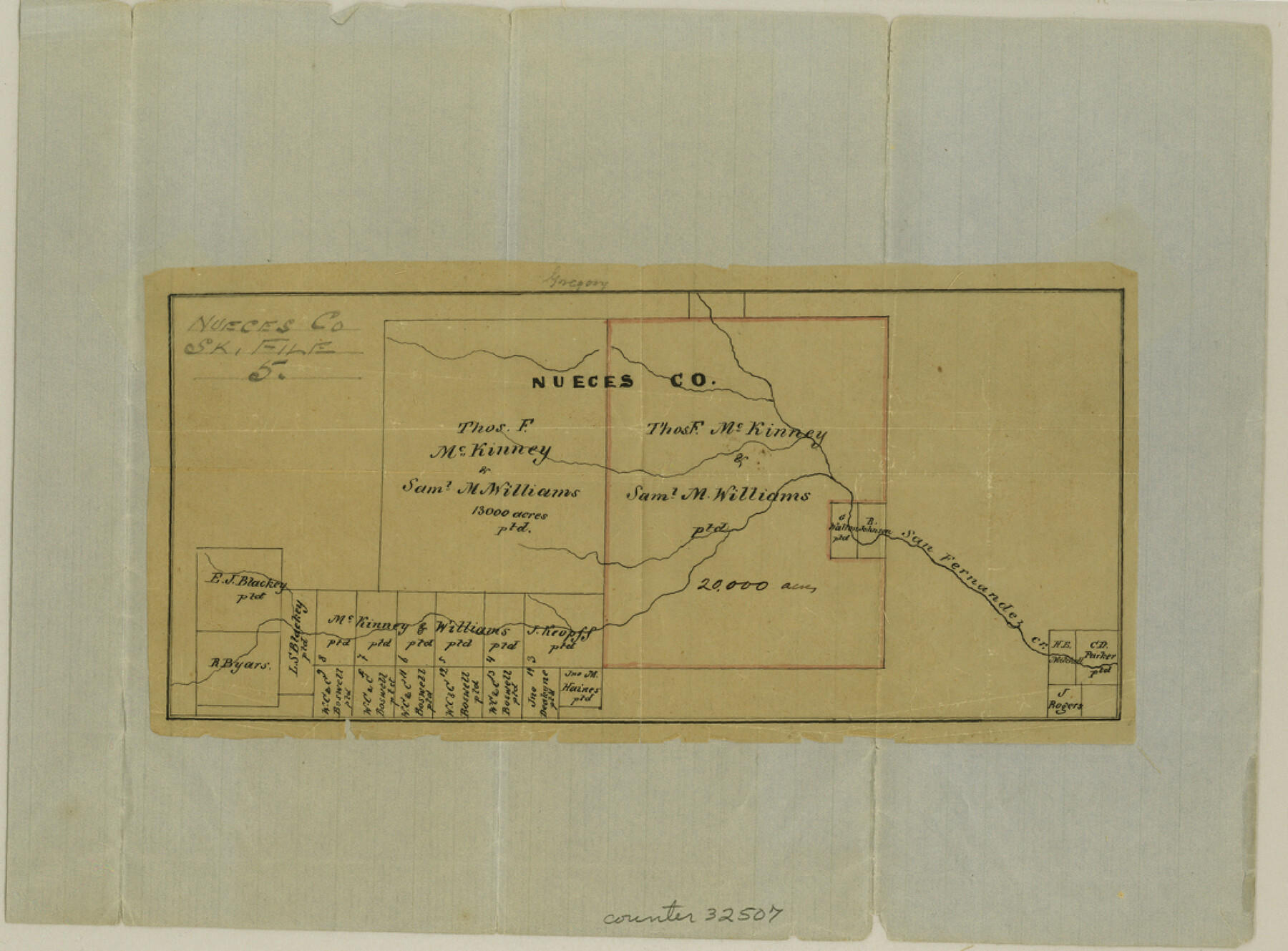
Nueces County Sketch File 5
[Sketch of McKinney and Williams grants along San Fernando Creek]
-
Map/Doc
32507
-
Collection
General Map Collection
-
Object Dates
6/1/1855 (File Date)
-
Counties
Nueces
-
Subjects
Surveying Sketch File
-
Height x Width
8.1 x 11.0 inches
20.6 x 27.9 cm
-
Medium
paper, manuscript
-
Features
San Fernandez Creek
Part of: General Map Collection
Dimmit County Working Sketch 25

Print $20.00
- Digital $50.00
Dimmit County Working Sketch 25
1955
Size 24.9 x 18.3 inches
Map/Doc 68686
[Surveys along the San Marcos River]
![158, [Surveys along the San Marcos River], General Map Collection](https://historictexasmaps.com/wmedia_w700/maps/158.tif.jpg)
Print $2.00
- Digital $50.00
[Surveys along the San Marcos River]
Size 7.7 x 5.8 inches
Map/Doc 158
Texas Intracoastal Waterway - Stover Point to Port Brownsville including Brazos Santiago

Print $20.00
- Digital $50.00
Texas Intracoastal Waterway - Stover Point to Port Brownsville including Brazos Santiago
1965
Size 27.5 x 38.9 inches
Map/Doc 73521
Eastland County Working Sketch 38

Print $20.00
- Digital $50.00
Eastland County Working Sketch 38
1969
Size 28.9 x 28.6 inches
Map/Doc 68819
Flight Mission No. CLL-1N, Frame 159, Willacy County

Print $20.00
- Digital $50.00
Flight Mission No. CLL-1N, Frame 159, Willacy County
1954
Size 18.4 x 22.2 inches
Map/Doc 87050
Hardin County Working Sketch 21

Print $20.00
- Digital $50.00
Hardin County Working Sketch 21
1947
Size 43.2 x 38.4 inches
Map/Doc 63419
Fisher County Sketch File 5

Print $20.00
- Digital $50.00
Fisher County Sketch File 5
1887
Size 35.3 x 47.6 inches
Map/Doc 10449
Bexar County Sketch File 47

Print $40.00
- Digital $50.00
Bexar County Sketch File 47
1896
Size 9.9 x 19.6 inches
Map/Doc 10925
Frio County Sketch File 16

Print $8.00
- Digital $50.00
Frio County Sketch File 16
1949
Size 11.3 x 8.8 inches
Map/Doc 23148
Dimmit County Boundary File 6a

Print $6.00
- Digital $50.00
Dimmit County Boundary File 6a
Size 8.9 x 3.9 inches
Map/Doc 52587
Eastland County Boundary File 26

Print $24.00
- Digital $50.00
Eastland County Boundary File 26
Size 7.8 x 3.5 inches
Map/Doc 52801
Parker County Sketch File 40

Print $4.00
- Digital $50.00
Parker County Sketch File 40
Size 8.1 x 12.7 inches
Map/Doc 33585
You may also like
Enochs Land situated in Bailey and Cochran Counties, Texas

Print $20.00
- Digital $50.00
Enochs Land situated in Bailey and Cochran Counties, Texas
Size 28.9 x 35.6 inches
Map/Doc 90194
Presidio County Working Sketch 31

Print $20.00
- Digital $50.00
Presidio County Working Sketch 31
1946
Size 25.2 x 26.3 inches
Map/Doc 71708
Stephens County Sketch File 9a

Print $4.00
- Digital $50.00
Stephens County Sketch File 9a
1884
Size 8.6 x 8.2 inches
Map/Doc 37040
Right of Way and Track Map, the Missouri, Kansas and Texas Ry. of Texas operated by the Missouri, Kansas and Texas Ry. of Texas, San Antonio Division

Print $40.00
- Digital $50.00
Right of Way and Track Map, the Missouri, Kansas and Texas Ry. of Texas operated by the Missouri, Kansas and Texas Ry. of Texas, San Antonio Division
1918
Size 25.6 x 57.8 inches
Map/Doc 64582
Crockett County Sketch File 10 and 11

Print $8.00
- Digital $50.00
Crockett County Sketch File 10 and 11
Size 12.6 x 7.3 inches
Map/Doc 19661
Flight Mission No. CRC-4R, Frame 109, Chambers County

Print $20.00
- Digital $50.00
Flight Mission No. CRC-4R, Frame 109, Chambers County
1956
Size 18.5 x 22.5 inches
Map/Doc 84906
Aransas County Rolled Sketch 24A

Print $20.00
- Digital $50.00
Aransas County Rolled Sketch 24A
Size 15.8 x 24.1 inches
Map/Doc 5062
Flight Mission No. DIX-6P, Frame 126, Aransas County

Print $20.00
- Digital $50.00
Flight Mission No. DIX-6P, Frame 126, Aransas County
1956
Size 19.3 x 22.9 inches
Map/Doc 83832
San Patricio County Rolled Sketch 47

Print $20.00
- Digital $50.00
San Patricio County Rolled Sketch 47
1939
Size 27.6 x 29.6 inches
Map/Doc 7731

[I. & G. N. Block 1, Secs. 65-75]
![90305, [I. & G. N. Block 1, Secs. 65-75], Twichell Survey Records](https://historictexasmaps.com/wmedia_w700/maps/90305-1.tif.jpg)
Print $20.00
- Digital $50.00
[I. & G. N. Block 1, Secs. 65-75]
1928
Size 24.6 x 21.5 inches
Map/Doc 90305
Survey Gulf to Beaumont and Orange, Texas

Print $20.00
- Digital $50.00
Survey Gulf to Beaumont and Orange, Texas
1929
Size 29.3 x 41.7 inches
Map/Doc 3089