Fisher County Sketch File 5
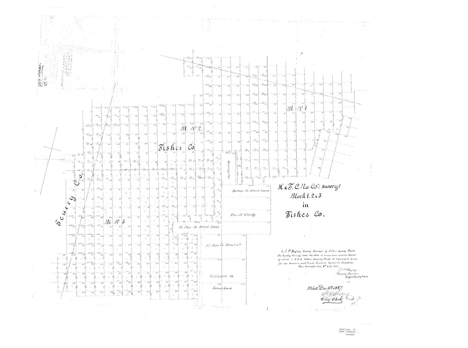
H&TC Rw. Co's. Surveys Block 1, 2, & 3 in Fisher Co.
- 
                          Map/Doc10449
- 
                            CollectionGeneral Map Collection
- 
                            Object Dates1887/11/8 (Creation Date)1887/12/6 (File Date)
- 
                            People and OrganizationsJ.P. Bagley (Surveyor/Engineer)
- 
                            CountiesFisher Scurry Stonewall
- 
                            SubjectsSurveying Sketch File
- 
                            Height x Width35.3 x 47.6 inches89.7 x 120.9 cm
- 
                            Mediumpaper, photocopy
Part of: General Map Collection
            Guadalupe County Sketch File 22


                                            Print $20.00                    
                                             -                         Digital $50.00                                    
                Guadalupe County Sketch File 22
1957
Size 16.2 x 16.5 inches
                                Map/Doc 11591
            
            Carson County Sketch File 6


                                            Print $32.00                    
                                             -                         Digital $50.00                                    
                Carson County Sketch File 6
1928
Size 9.1 x 9.6 inches
                                Map/Doc 17358
            
            Falls County Sketch File 2a


                                            Print $2.00                    
                                             -                         Digital $50.00                                    
                Falls County Sketch File 2a
1856
Size 8.4 x 10.9 inches
                                Map/Doc 22334
            
            Gaines County Working Sketch 28


                                            Print $20.00                    
                                             -                         Digital $50.00                                    
                Gaines County Working Sketch 28
1982
Size 20.9 x 24.6 inches
                                Map/Doc 69328
            
            Culberson County Rolled Sketch 39


                                            Print $20.00                    
                                             -                         Digital $50.00                                    
                Culberson County Rolled Sketch 39
Size 20.5 x 28.7 inches
                                Map/Doc 78465
            
            Van Zandt County Sketch File 17 and 17a


                                            Print $6.00                    
                                             -                         Digital $50.00                                    
                Van Zandt County Sketch File 17 and 17a
1858
Size 14.2 x 8.1 inches
                                Map/Doc 39417
            
            King County Working Sketch 3


                                            Print $20.00                    
                                             -                         Digital $50.00                                    
                King County Working Sketch 3
1934
Size 10.4 x 20.1 inches
                                Map/Doc 70167
            
            Val Verde County Working Sketch 107


                                            Print $20.00                    
                                             -                         Digital $50.00                                    
                Val Verde County Working Sketch 107
Size 32.8 x 43.5 inches
                                Map/Doc 72242
            
            The Coast of Texas


                                            Print $20.00                    
                                             -                         Digital $50.00                                    
                The Coast of Texas
1844
Size 18.3 x 26.9 inches
                                Map/Doc 72698
            
            Flight Mission No. BRA-9M, Frame 70, Jefferson County


                                            Print $20.00                    
                                             -                         Digital $50.00                                    
                Flight Mission No. BRA-9M, Frame 70, Jefferson County
1953
Size 18.6 x 22.5 inches
                                Map/Doc 85653
            
            Kinney County


                                            Print $40.00                    
                                             -                         Digital $50.00                                    
                Kinney County
1955
Size 48.9 x 42.4 inches
                                Map/Doc 77342
            You may also like
            Red River County Sketch File 17b


                                            Print $4.00                    
                                             -                         Digital $50.00                                    
                Red River County Sketch File 17b
1875
Size 12.9 x 8.1 inches
                                Map/Doc 35147
            
            Henderson County Sketch File 1


                                            Print $8.00                    
                                             -                         Digital $50.00                                    
                Henderson County Sketch File 1
Size 12.8 x 8.3 inches
                                Map/Doc 26318
            
            [Rusk, Sutton, Garza, and Atascosa County School Lands]
            
                                    ![91219, [Rusk, Sutton, Garza, and Atascosa County School Lands], Twichell Survey Records](https://historictexasmaps.com/wmedia_w700/maps/91219-1.tif.jpg) 


    ![91219, [Rusk, Sutton, Garza, and Atascosa County School Lands], Twichell Survey Records](https://historictexasmaps.com/wmedia_w700/maps/91219-1.tif.jpg) 
                                
            
                                            Print $20.00                    
                                             -                         Digital $50.00                                    
                [Rusk, Sutton, Garza, and Atascosa County School Lands]
1913
Size 18.8 x 14.5 inches
                                Map/Doc 91219
            
            Kenedy County Rolled Sketch 17


                                            Print $40.00                    
                                             -                         Digital $50.00                                    
                Kenedy County Rolled Sketch 17
1958
Size 96.6 x 28.5 inches
                                Map/Doc 10726
            
            [Tie Line, Zavala County School Land to North Line of Block D11, East and South to Double Lakes Corner]
            
                                    ![91868, [Tie Line, Zavala County School Land to North Line of Block D11, East and South to Double Lakes Corner], Twichell Survey Records](https://historictexasmaps.com/wmedia_w700/maps/91868-1.tif.jpg) 


    ![91868, [Tie Line, Zavala County School Land to North Line of Block D11, East and South to Double Lakes Corner], Twichell Survey Records](https://historictexasmaps.com/wmedia_w700/maps/91868-1.tif.jpg) 
                                
            
                                            Print $20.00                    
                                             -                         Digital $50.00                                    
                [Tie Line, Zavala County School Land to North Line of Block D11, East and South to Double Lakes Corner]
1900
Size 18.5 x 12.6 inches
                                Map/Doc 91868
            
            Reeves County


                                            Print $20.00                    
                                             -                         Digital $50.00                                    
                Reeves County
1915
Size 23.6 x 29.8 inches
                                Map/Doc 92896
            
            Terrell County Working Sketch 39


                                            Print $20.00                    
                                             -                         Digital $50.00                                    
                Terrell County Working Sketch 39
1951
Size 26.8 x 40.4 inches
                                Map/Doc 62132
            
            Red River, Bois D'Arc Creek Floodway Sheet No. 2


                                            Print $20.00                    
                                             -                         Digital $50.00                                    
                Red River, Bois D'Arc Creek Floodway Sheet No. 2
1917
Size 20.4 x 29.9 inches
                                Map/Doc 69657
            
            Hudspeth County Working Sketch 11


                                            Print $20.00                    
                                             -                         Digital $50.00                                    
                Hudspeth County Working Sketch 11
1946
Size 32.1 x 36.2 inches
                                Map/Doc 66292
            
            Brazoria County NRC Article 33.136 Sketch 26


                                            Print $24.00                    
                                    
                Brazoria County NRC Article 33.136 Sketch 26
2025
Map/Doc 97471
            
            Working Sketch of Surveys in Garza Co. About 12 Miles N. from Post City


                                            Print $40.00                    
                                             -                         Digital $50.00                                    
                Working Sketch of Surveys in Garza Co. About 12 Miles N. from Post City
1950
Size 48.5 x 37.4 inches
                                Map/Doc 89872
            
            [Blocks B16, B7, B15]
            
                                    ![93130, [Blocks B16, B7, B15], Twichell Survey Records](https://historictexasmaps.com/wmedia_w700/maps/93130-1.tif.jpg) 


    ![93130, [Blocks B16, B7, B15], Twichell Survey Records](https://historictexasmaps.com/wmedia_w700/maps/93130-1.tif.jpg) 
                                
            
                                            Print $40.00                    
                                             -                         Digital $50.00                                    
                [Blocks B16, B7, B15]
Size 57.2 x 51.5 inches
                                Map/Doc 93130
             
                            ![94159, Austin Street Map [Verso], General Map Collection](https://historictexasmaps.com/wmedia_w700/maps/94159.tif.jpg)