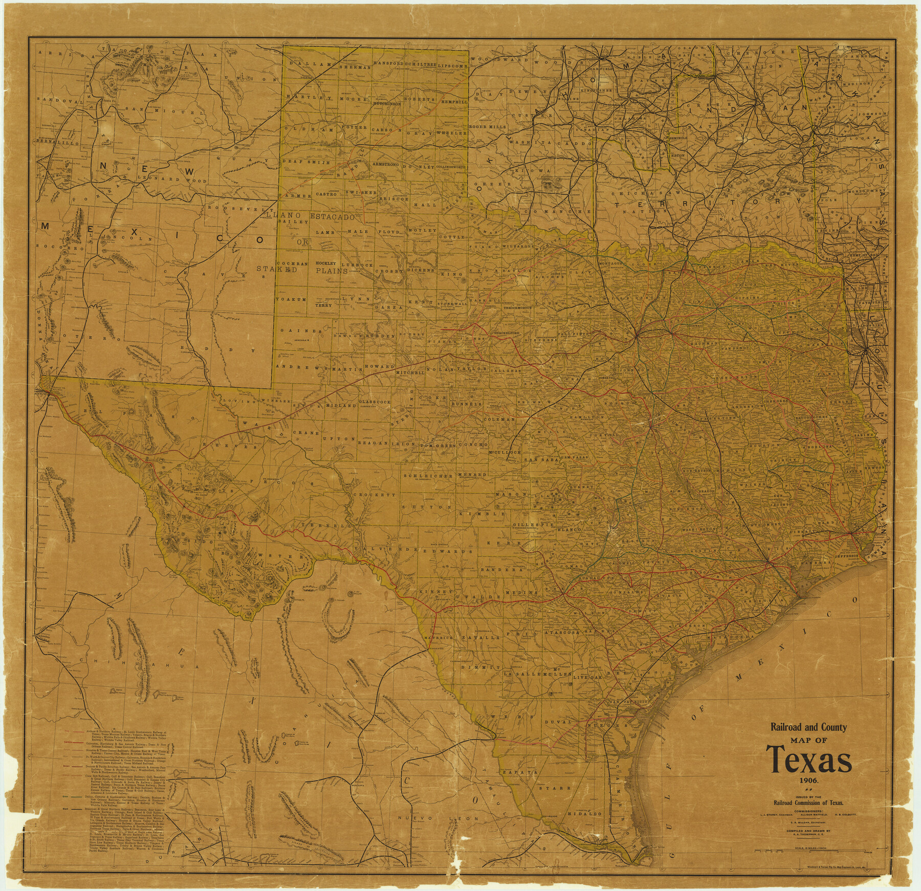
Railroad and County Map of Texas
Z-1-12
-
Map/Doc
10748
-
Collection
General Map Collection
-
Object Dates
1906 (Creation Date)
-
People and Organizations
Railroad Commission of Texas (Publisher)
Woodward and Tiernan Ptg. Co., Map Engravers (Printer)
Railroad Commission of Texas (Author)
R.A. Thompson (Draftsman)
R.A. Thompson (Compiler)
-
Subjects
Railroads State of Texas
-
Height x Width
46.0 x 47.6 inches
116.8 x 120.9 cm
-
Comments
Conservation funded in 2001 with donation from Frost Bank.
Part of: General Map Collection
Andrews County Rolled Sketch 38

Print $40.00
- Digital $50.00
Andrews County Rolled Sketch 38
1963
Size 38.3 x 50.3 inches
Map/Doc 8400
Zapata County Working Sketch 2

Print $20.00
- Digital $50.00
Zapata County Working Sketch 2
1930
Size 26.0 x 20.3 inches
Map/Doc 62053
Hardeman County Sketch File 32

Print $4.00
- Digital $50.00
Hardeman County Sketch File 32
Size 11.1 x 8.9 inches
Map/Doc 25068
Packery Channel

Print $20.00
- Digital $50.00
Packery Channel
1937
Size 23.8 x 22.4 inches
Map/Doc 3008
Bosque County Working Sketch 25

Print $20.00
- Digital $50.00
Bosque County Working Sketch 25
1994
Size 36.6 x 47.9 inches
Map/Doc 67459
McMullen County

Print $20.00
- Digital $50.00
McMullen County
1967
Size 40.7 x 27.8 inches
Map/Doc 77363
Duval County Rolled Sketch E

Print $20.00
- Digital $50.00
Duval County Rolled Sketch E
1935
Size 36.4 x 37.7 inches
Map/Doc 8808
Sherman County Rolled Sketch 5

Print $20.00
- Digital $50.00
Sherman County Rolled Sketch 5
1919
Size 36.9 x 41.4 inches
Map/Doc 9928
Galveston, Harrisburg & San Antonio Railway, Map of Eagle Pass Branch

Print $20.00
- Digital $50.00
Galveston, Harrisburg & San Antonio Railway, Map of Eagle Pass Branch
1888
Size 42.7 x 25.8 inches
Map/Doc 64462
Red River County Sketch File 2

Print $8.00
- Digital $50.00
Red River County Sketch File 2
1852
Size 12.9 x 8.5 inches
Map/Doc 35095
Real County Working Sketch 50

Print $20.00
- Digital $50.00
Real County Working Sketch 50
1957
Size 19.8 x 26.1 inches
Map/Doc 71942
Webb County Working Sketch 80

Print $40.00
- Digital $50.00
Webb County Working Sketch 80
1979
Size 43.0 x 97.9 inches
Map/Doc 72447
You may also like
Refugio County Working Sketch Graphic Index

Print $20.00
- Digital $50.00
Refugio County Working Sketch Graphic Index
1921
Size 38.9 x 47.8 inches
Map/Doc 76683
Comanche County Sketch File 26

Print $20.00
- Digital $50.00
Comanche County Sketch File 26
Size 18.0 x 17.5 inches
Map/Doc 11144
[Blocks 71 and C-8]
![91778, [Blocks 71 and C-8], Twichell Survey Records](https://historictexasmaps.com/wmedia_w700/maps/91778-1.tif.jpg)
Print $20.00
- Digital $50.00
[Blocks 71 and C-8]
Size 29.7 x 21.1 inches
Map/Doc 91778
Dimmit County Sketch File 30

Print $4.00
- Digital $50.00
Dimmit County Sketch File 30
Size 10.6 x 8.5 inches
Map/Doc 21146
Runnels County Working Sketch 35a
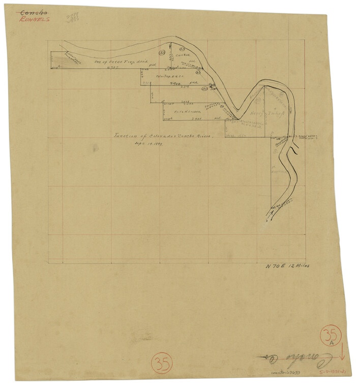
Print $20.00
- Digital $50.00
Runnels County Working Sketch 35a
Size 14.9 x 14.2 inches
Map/Doc 63633
Presidio County Rolled Sketch 87

Print $20.00
- Digital $50.00
Presidio County Rolled Sketch 87
Size 26.4 x 38.2 inches
Map/Doc 7373
Cherokee County Sketch File 20

Print $4.00
- Digital $50.00
Cherokee County Sketch File 20
1876
Size 8.2 x 6.0 inches
Map/Doc 18163
Flight Mission No. CLL-1N, Frame 39, Willacy County

Print $20.00
- Digital $50.00
Flight Mission No. CLL-1N, Frame 39, Willacy County
1954
Size 18.4 x 22.0 inches
Map/Doc 87020
[Blocks K3, K4, K7, K8, K14, M7, east part of Leagues]
![90592, [Blocks K3, K4, K7, K8, K14, M7, east part of Leagues], Twichell Survey Records](https://historictexasmaps.com/wmedia_w700/maps/90592-1.tif.jpg)
Print $20.00
- Digital $50.00
[Blocks K3, K4, K7, K8, K14, M7, east part of Leagues]
Size 33.4 x 31.8 inches
Map/Doc 90592
General Highway Map, Jackson County, Texas

Print $20.00
General Highway Map, Jackson County, Texas
1940
Size 18.3 x 24.8 inches
Map/Doc 79140
Gonzales County, Texas

Print $20.00
- Digital $50.00
Gonzales County, Texas
1880
Size 27.3 x 24.7 inches
Map/Doc 447
Johnson County Working Sketch 18

Print $20.00
- Digital $50.00
Johnson County Working Sketch 18
1985
Size 18.3 x 26.0 inches
Map/Doc 66631