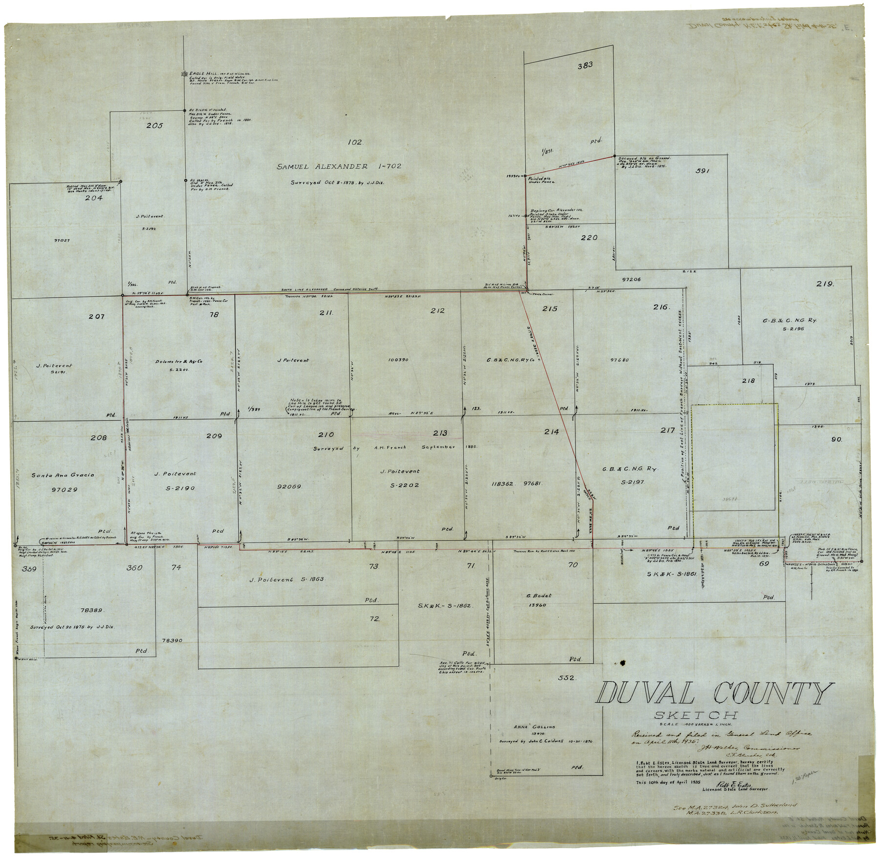
Duval County Rolled Sketch E
Duval County Sketch
-
Map/Doc
8808
-
Collection
General Map Collection
-
Object Dates
4/10/1935 (Creation Date)
4/11/1935 (File Date)
-
People and Organizations
Robt. E. Estes (Surveyor/Engineer)
-
Counties
Duval
-
Subjects
Surveying Rolled Sketch
-
Height x Width
36.4 x 37.7 inches
92.5 x 95.8 cm
-
Medium
linen, manuscript
-
Scale
1" = 400 varas
-
Comments
See Duval County Sketch File 85 (21534) for report and correspondence.
Related maps
Duval County Sketch File 85

Print $27.00
- Digital $50.00
Duval County Sketch File 85
1935
Size 14.3 x 9.1 inches
Map/Doc 21534
Part of: General Map Collection
Orange County Rolled Sketch 22

Print $40.00
- Digital $50.00
Orange County Rolled Sketch 22
1950
Size 31.2 x 58.0 inches
Map/Doc 9647
Fractional Township No. 8 South Range No. 2 East of the Indian Meridian, Indian Territory

Print $20.00
- Digital $50.00
Fractional Township No. 8 South Range No. 2 East of the Indian Meridian, Indian Territory
1898
Size 19.3 x 24.3 inches
Map/Doc 75204
Motley County Working Sketch 3

Print $20.00
- Digital $50.00
Motley County Working Sketch 3
1914
Size 13.2 x 20.4 inches
Map/Doc 71208
Motley County Boundary File 2b

Print $60.00
- Digital $50.00
Motley County Boundary File 2b
Size 14.3 x 8.8 inches
Map/Doc 57521
Caldwell County Sketch File 4a

Print $8.00
- Digital $50.00
Caldwell County Sketch File 4a
1898
Size 11.2 x 8.8 inches
Map/Doc 35835
Montgomery County Rolled Sketch 46

Print $20.00
- Digital $50.00
Montgomery County Rolled Sketch 46
2006
Size 28.2 x 23.0 inches
Map/Doc 87940
Dallas County Boundary File 6e

Print $70.00
- Digital $50.00
Dallas County Boundary File 6e
Size 16.6 x 22.5 inches
Map/Doc 52254
Montgomery County Rolled Sketch 40A

Print $40.00
- Digital $50.00
Montgomery County Rolled Sketch 40A
1970
Size 40.4 x 57.5 inches
Map/Doc 9547
Ochiltree County Boundary File 8

Print $8.00
- Digital $50.00
Ochiltree County Boundary File 8
Size 11.2 x 8.7 inches
Map/Doc 57716
Ward County Working Sketch 14

Print $20.00
- Digital $50.00
Ward County Working Sketch 14
1947
Size 30.3 x 28.8 inches
Map/Doc 72320
Flight Mission No. DCL-7C, Frame 41, Kenedy County

Print $20.00
- Digital $50.00
Flight Mission No. DCL-7C, Frame 41, Kenedy County
1943
Size 15.4 x 15.2 inches
Map/Doc 86029
Map of Falls County

Print $20.00
- Digital $50.00
Map of Falls County
1874
Size 20.3 x 21.5 inches
Map/Doc 3528
You may also like
Parker County Sketch File 16

Print $22.00
- Digital $50.00
Parker County Sketch File 16
1870
Size 12.9 x 16.3 inches
Map/Doc 33550
Hunt County Sketch File 4

Print $4.00
- Digital $50.00
Hunt County Sketch File 4
1852
Size 12.1 x 7.7 inches
Map/Doc 27087
Webb County Working Sketch 35

Print $40.00
- Digital $50.00
Webb County Working Sketch 35
1939
Size 54.5 x 36.2 inches
Map/Doc 72400
Galveston County NRC Article 33.136 Location Key Sheet

Print $20.00
- Digital $50.00
Galveston County NRC Article 33.136 Location Key Sheet
1993
Size 27.3 x 23.0 inches
Map/Doc 83000
[E. T. Ry. Blk. 1]
![89796, [E. T. Ry. Blk. 1], Twichell Survey Records](https://historictexasmaps.com/wmedia_w700/maps/89796-1.tif.jpg)
Print $40.00
- Digital $50.00
[E. T. Ry. Blk. 1]
Size 41.1 x 50.4 inches
Map/Doc 89796
Sterling County Rolled Sketch 17

Print $40.00
- Digital $50.00
Sterling County Rolled Sketch 17
Size 61.0 x 48.4 inches
Map/Doc 9949
Sketch of a reconnaissance of Aransas and Corpus Christi Bays

Print $20.00
- Digital $50.00
Sketch of a reconnaissance of Aransas and Corpus Christi Bays
1855
Size 25.5 x 18.2 inches
Map/Doc 72968
Burnet County Sketch File 19

Print $4.00
- Digital $50.00
Burnet County Sketch File 19
1859
Size 11.6 x 8.2 inches
Map/Doc 16710
Hardin County Sketch File 51

Print $9.00
- Digital $50.00
Hardin County Sketch File 51
Size 9.9 x 8.1 inches
Map/Doc 25206
Topographical Map of the Rio Grande, Sheet No. 1

Print $20.00
- Digital $50.00
Topographical Map of the Rio Grande, Sheet No. 1
1912
Map/Doc 89525
Lamb County, Texas Compiled by Sylvan Sanders Lubbock, Texas

Print $20.00
- Digital $50.00
Lamb County, Texas Compiled by Sylvan Sanders Lubbock, Texas
Size 24.0 x 27.2 inches
Map/Doc 92200
Map Showing Eastern Portion of Pecos County, Texas

Print $40.00
- Digital $50.00
Map Showing Eastern Portion of Pecos County, Texas
Size 62.2 x 43.5 inches
Map/Doc 89835