Montgomery County Rolled Sketch 40A
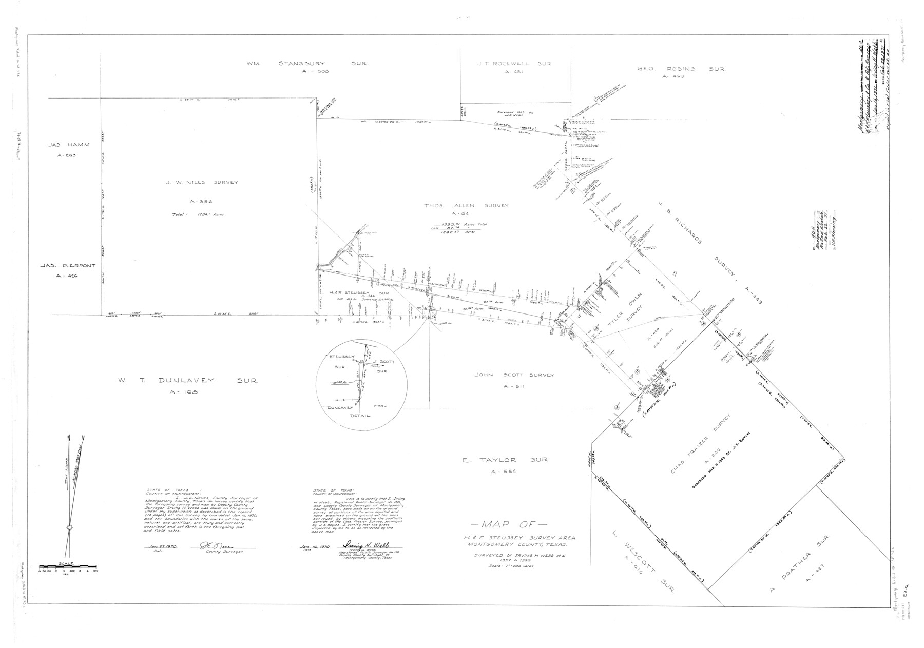
Map of H. & F. Steussey survey area, Montgomery County, Texas
-
Map/Doc
9547
-
Collection
General Map Collection
-
Object Dates
1970/1/16 (Creation Date)
1971/2/22 (File Date)
-
People and Organizations
Irving H. Webb (Surveyor/Engineer)
-
Counties
Montgomery
-
Subjects
Surveying Rolled Sketch
-
Height x Width
40.4 x 57.5 inches
102.6 x 146.1 cm
-
Scale
1" = 200 varas
-
Comments
See Montgomery County Rolled Sketch 40 (46793) for report and additional sketches.
Related maps
Montgomery County Rolled Sketch 40

Print $393.00
- Digital $50.00
Montgomery County Rolled Sketch 40
1970
Size 10.3 x 16.0 inches
Map/Doc 46793
Part of: General Map Collection
Clay County Rolled Sketch 1

Print $20.00
- Digital $50.00
Clay County Rolled Sketch 1
1940
Size 47.0 x 37.9 inches
Map/Doc 8621
Val Verde County Working Sketch 77

Print $20.00
- Digital $50.00
Val Verde County Working Sketch 77
1972
Size 45.9 x 38.5 inches
Map/Doc 72212
Schleicher County Sketch File 39

Print $9.00
- Digital $50.00
Schleicher County Sketch File 39
1958
Size 14.8 x 9.4 inches
Map/Doc 36538
Mason County Sketch File 7

Print $4.00
- Digital $50.00
Mason County Sketch File 7
Size 7.9 x 8.8 inches
Map/Doc 30689
Mitchell County

Print $20.00
- Digital $50.00
Mitchell County
1922
Size 43.4 x 38.2 inches
Map/Doc 66936
Hall County Sketch File B2

Print $20.00
- Digital $50.00
Hall County Sketch File B2
1904
Size 21.7 x 35.1 inches
Map/Doc 11613
Travis County Boundary File 5

Print $62.00
- Digital $50.00
Travis County Boundary File 5
Size 9.1 x 4.4 inches
Map/Doc 59430
Maps of Gulf Intracoastal Waterway, Texas - Sabine River to the Rio Grande and connecting waterways including ship channels

Print $20.00
- Digital $50.00
Maps of Gulf Intracoastal Waterway, Texas - Sabine River to the Rio Grande and connecting waterways including ship channels
1966
Size 14.5 x 22.2 inches
Map/Doc 61969
Floyd County Boundary File 1

Print $30.00
- Digital $50.00
Floyd County Boundary File 1
Size 8.9 x 4.2 inches
Map/Doc 53445
Pecos County Rolled Sketch 82

Print $20.00
- Digital $50.00
Pecos County Rolled Sketch 82
1930
Size 28.4 x 25.7 inches
Map/Doc 10190
Pecos County Rolled Sketch 146

Print $20.00
- Digital $50.00
Pecos County Rolled Sketch 146
Size 40.8 x 32.5 inches
Map/Doc 9734
Presidio County Working Sketch 46

Print $40.00
- Digital $50.00
Presidio County Working Sketch 46
1947
Size 36.8 x 59.0 inches
Map/Doc 71723
You may also like
Nueces County Sketch File 83

Print $63.00
- Digital $50.00
Nueces County Sketch File 83
1997
Size 11.1 x 8.5 inches
Map/Doc 43013
Gregg County Sketch File 7

Print $20.00
- Digital $50.00
Gregg County Sketch File 7
1931
Size 42.9 x 34.8 inches
Map/Doc 10466
Houston County Working Sketch 26

Print $20.00
- Digital $50.00
Houston County Working Sketch 26
1987
Size 30.1 x 20.4 inches
Map/Doc 66256
Glasscock County Working Sketch 9

Print $40.00
- Digital $50.00
Glasscock County Working Sketch 9
1957
Size 77.9 x 25.5 inches
Map/Doc 63182
Castro County Sketch File 4f

Print $4.00
- Digital $50.00
Castro County Sketch File 4f
Size 13.8 x 8.9 inches
Map/Doc 17475
Duval County Sketch File 25

Print $8.00
- Digital $50.00
Duval County Sketch File 25
Size 11.4 x 9.1 inches
Map/Doc 21328
Motley County Sketch File F (S)

Print $14.00
- Digital $50.00
Motley County Sketch File F (S)
1904
Size 9.1 x 5.9 inches
Map/Doc 32179
Hopkins County Working Sketch 4

Print $20.00
- Digital $50.00
Hopkins County Working Sketch 4
1959
Size 23.3 x 30.9 inches
Map/Doc 66229
Stonewall County Working Sketch Graphic Index - sheet A

Print $20.00
- Digital $50.00
Stonewall County Working Sketch Graphic Index - sheet A
1933
Size 43.3 x 36.2 inches
Map/Doc 76704
General Highway Map, El Paso County, Texas

Print $20.00
General Highway Map, El Paso County, Texas
1961
Size 18.2 x 24.7 inches
Map/Doc 79454
The Mexican Municipality of Mina. ca. Spring 1835

Print $20.00
The Mexican Municipality of Mina. ca. Spring 1835
2020
Size 10.7 x 21.8 inches
Map/Doc 96029
Haskell County Working Sketch 16

Print $20.00
- Digital $50.00
Haskell County Working Sketch 16
1986
Size 37.9 x 47.3 inches
Map/Doc 66074