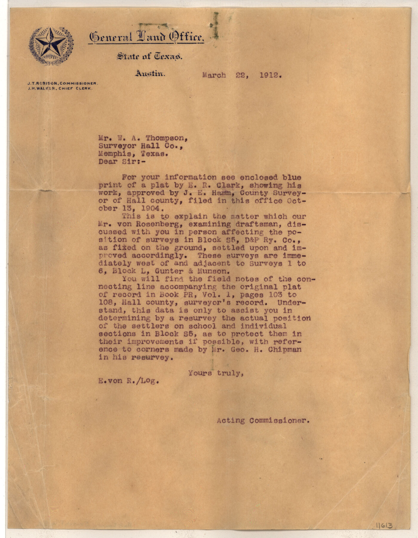
Hall County Sketch File B2
Hamm's sk. of surs. in Blk. S5
-
Map/Doc
11613
-
Collection
General Map Collection
-
Object Dates
1912/3/22 (File Date)
1904/10/13 (File Date)
1904 (Survey Date)
1904 (Creation Date)
-
People and Organizations
E.R. Clark (Draftsman)
E.R. Clark (Surveyor/Engineer)
George H. Chipman (Surveyor/Engineer)
James E. Hamm (Surveyor/Engineer)
-
Counties
Hall Briscoe
-
Subjects
Surveying Sketch File
-
Height x Width
21.7 x 35.1 inches
55.1 x 89.2 cm
-
Medium
multi-page, multi-format
-
Features
Antelope Creek
Wild Cat Creek
Parker Creek
Blyth Creek
Turkey Creek
Little Red Creek
Oxbow Creek
Lost Mule Creek
Cotton Wood Creek
Wind River
Part of: General Map Collection
Sabine River, Rocky Point Crossing Sheet

Print $4.00
- Digital $50.00
Sabine River, Rocky Point Crossing Sheet
Size 24.0 x 24.6 inches
Map/Doc 65134
Erath County Working Sketch 33

Print $20.00
- Digital $50.00
Erath County Working Sketch 33
1972
Size 25.1 x 21.0 inches
Map/Doc 69114

Montague County

Print $20.00
- Digital $50.00
Montague County
1875
Size 24.6 x 21.1 inches
Map/Doc 3884
Trace of a copy of the map captured at the battle of Resaca de la Palma

Print $20.00
- Digital $50.00
Trace of a copy of the map captured at the battle of Resaca de la Palma
Size 18.3 x 27.6 inches
Map/Doc 73053
Atascosa County Sketch File 33

Print $40.00
- Digital $50.00
Atascosa County Sketch File 33
1916
Size 24.9 x 19.7 inches
Map/Doc 10865
Flight Mission No. CUG-1P, Frame 165, Kleberg County

Print $20.00
- Digital $50.00
Flight Mission No. CUG-1P, Frame 165, Kleberg County
1956
Size 18.7 x 22.2 inches
Map/Doc 86172

Parker County Sketch File 16

Print $22.00
- Digital $50.00
Parker County Sketch File 16
1870
Size 12.9 x 16.3 inches
Map/Doc 33550
Flight Mission No. CRC-3R, Frame 16, Chambers County

Print $20.00
- Digital $50.00
Flight Mission No. CRC-3R, Frame 16, Chambers County
1956
Size 18.6 x 22.2 inches
Map/Doc 84790
Foard County Sketch File 14

Print $4.00
- Digital $50.00
Foard County Sketch File 14
1885
Size 14.4 x 8.8 inches
Map/Doc 22819
Grayson County Boundary File 2a

Print $60.00
- Digital $50.00
Grayson County Boundary File 2a
Size 43.7 x 9.8 inches
Map/Doc 53938
You may also like
Plat showing surveys made for N. Vasquez, Sr. of Casa Piedra, Texas in Block 312, T. C. Ry. Co.

Print $20.00
- Digital $50.00
Plat showing surveys made for N. Vasquez, Sr. of Casa Piedra, Texas in Block 312, T. C. Ry. Co.
1947
Size 16.5 x 22.3 inches
Map/Doc 2062
Uvalde County Sketch File 23

Print $20.00
- Digital $50.00
Uvalde County Sketch File 23
1923
Size 20.8 x 23.5 inches
Map/Doc 12534
Hidalgo County Working Sketch 9

Print $20.00
- Digital $50.00
Hidalgo County Working Sketch 9
1984
Size 27.2 x 15.0 inches
Map/Doc 66186
Mexico, California and Texas

Print $20.00
Mexico, California and Texas
1850
Size 11.1 x 15.0 inches
Map/Doc 82964
Montague County Sketch File 21

Print $4.00
- Digital $50.00
Montague County Sketch File 21
1888
Size 12.4 x 8.3 inches
Map/Doc 31751
Flight Mission No. DQN-2K, Frame 99, Calhoun County

Print $20.00
- Digital $50.00
Flight Mission No. DQN-2K, Frame 99, Calhoun County
1953
Size 18.7 x 22.3 inches
Map/Doc 84289
Map Showing Survey of Navasota River Bed in Limestone County Texas Located North of Houston and Texas Central Railroad Bridge

Print $20.00
- Digital $50.00
Map Showing Survey of Navasota River Bed in Limestone County Texas Located North of Houston and Texas Central Railroad Bridge
1921
Size 45.8 x 38.5 inches
Map/Doc 65348
Brewster County Working Sketch 112

Print $20.00
- Digital $50.00
Brewster County Working Sketch 112
1982
Size 28.1 x 26.8 inches
Map/Doc 67712
Harris County Rolled Sketch F

Print $40.00
- Digital $50.00
Harris County Rolled Sketch F
1933
Size 56.6 x 44.6 inches
Map/Doc 9121
Calhoun County Sketch File 7

Print $12.00
- Digital $50.00
Calhoun County Sketch File 7
1947
Size 14.5 x 8.9 inches
Map/Doc 35925
Brewster County Rolled Sketch 114

Print $20.00
- Digital $50.00
Brewster County Rolled Sketch 114
1964
Size 11.4 x 18.2 inches
Map/Doc 5282
