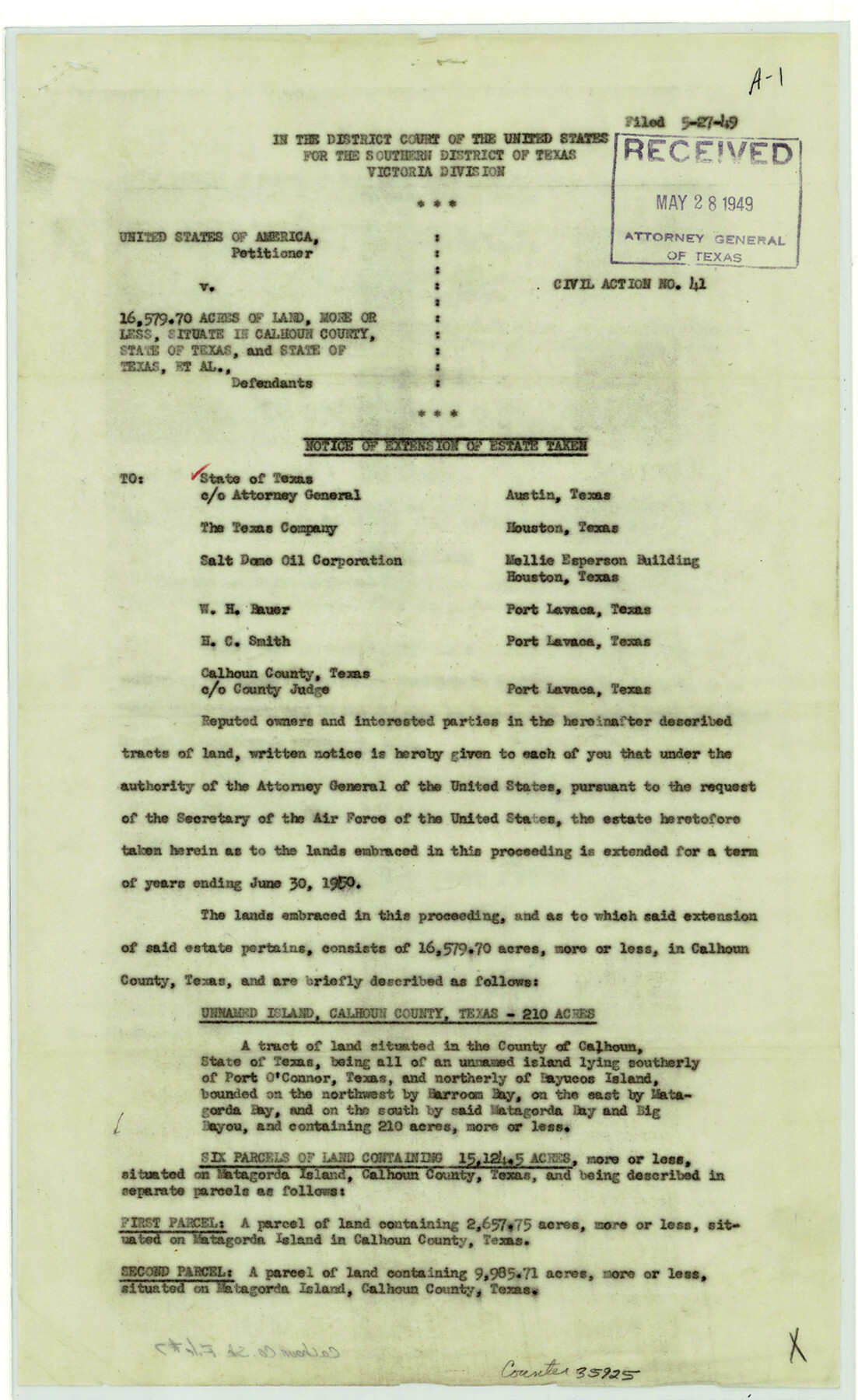
Calhoun County Sketch File 7
[Condemnation, Civil Action No. 41 - United States of America, petitioner vs. 16,579.70 acres of land, more or less, situated in Calhoun County, State of Texas, et al]
-
Map/Doc
35925
-
Collection
General Map Collection
-
Object Dates
1948/6/12 (File Date)
1947 (Creation Date)
-
Counties
Calhoun
-
Subjects
Surveying Sketch File
-
Height x Width
14.5 x 8.9 inches
36.8 x 22.6 cm
-
Medium
paper, print
-
Features
Unnamed Island
Port O'Connor
Bayucos Island
Matagorda Bay
Big Bayou
Grass Island
Farwell [sic] Island
Espiritu Santo Bay
Barroom Bay
Part of: General Map Collection
Austin County Sketch File 16

Print $74.00
- Digital $50.00
Austin County Sketch File 16
Size 14.3 x 8.8 inches
Map/Doc 13888
Flight Mission No. BRE-3P, Frame 79, Nueces County

Print $20.00
- Digital $50.00
Flight Mission No. BRE-3P, Frame 79, Nueces County
1956
Size 18.6 x 22.5 inches
Map/Doc 86820

El Paso County Sketch File 19

Print $30.00
- Digital $50.00
El Paso County Sketch File 19
1905
Size 13.3 x 8.7 inches
Map/Doc 22009
McMullen County Working Sketch 8

Print $20.00
- Digital $50.00
McMullen County Working Sketch 8
1936
Size 27.2 x 33.0 inches
Map/Doc 70709
Flight Mission No. CRC-3R, Frame 42, Chambers County

Print $20.00
- Digital $50.00
Flight Mission No. CRC-3R, Frame 42, Chambers County
1956
Size 18.8 x 22.4 inches
Map/Doc 84815
Wilbarger County Sketch File 13

Print $28.00
- Digital $50.00
Wilbarger County Sketch File 13
1885
Size 12.7 x 8.0 inches
Map/Doc 40189
Flight Mission No. CRC-4R, Frame 98, Chambers County

Print $20.00
- Digital $50.00
Flight Mission No. CRC-4R, Frame 98, Chambers County
1956
Size 18.6 x 22.3 inches
Map/Doc 84895
Map of Bee County

Print $20.00
- Digital $50.00
Map of Bee County
1879
Size 25.1 x 22.7 inches
Map/Doc 3289
Bell County Sketch File 35

Print $40.00
- Digital $50.00
Bell County Sketch File 35
1952
Size 22.0 x 24.3 inches
Map/Doc 10918
Wilbarger Co.

Print $40.00
- Digital $50.00
Wilbarger Co.
1907
Size 48.8 x 39.8 inches
Map/Doc 63127
Lubbock County Rolled Sketch 4

Print $20.00
- Digital $50.00
Lubbock County Rolled Sketch 4
Size 34.1 x 45.5 inches
Map/Doc 76179
You may also like
Located Line of the Panhandle & Gulf Ry. through State Lands, Public School and University, in Reagan County, Texas, Right of Way 200 feet wide

Print $40.00
- Digital $50.00
Located Line of the Panhandle & Gulf Ry. through State Lands, Public School and University, in Reagan County, Texas, Right of Way 200 feet wide
1904
Size 13.4 x 90.8 inches
Map/Doc 64063
[Reconnaissance report of Lieut. Scariott around Laguna del Madre and up to Fort San Saba]
![73006, [Reconnaissance report of Lieut. Scariott around Laguna del Madre and up to Fort San Saba], General Map Collection](https://historictexasmaps.com/wmedia_w700/maps/73006.tif.jpg)
Print $20.00
- Digital $50.00
[Reconnaissance report of Lieut. Scariott around Laguna del Madre and up to Fort San Saba]
Size 25.2 x 18.2 inches
Map/Doc 73006
McMullen County Working Sketch 3

Print $20.00
- Digital $50.00
McMullen County Working Sketch 3
1922
Size 21.1 x 10.8 inches
Map/Doc 70704
Marion County Working Sketch 32

Print $40.00
- Digital $50.00
Marion County Working Sketch 32
1982
Size 50.0 x 43.3 inches
Map/Doc 70808
Upton County Sketch File 17

Print $6.00
- Digital $50.00
Upton County Sketch File 17
Size 11.0 x 10.9 inches
Map/Doc 38875
Runnels County Rolled Sketch 43

Print $20.00
- Digital $50.00
Runnels County Rolled Sketch 43
Size 28.3 x 45.8 inches
Map/Doc 7531
Map of Texas compiled from surveys at the Land Office of Texas

Print $20.00
Map of Texas compiled from surveys at the Land Office of Texas
1851
Size 27.2 x 19.5 inches
Map/Doc 79748
Flight Mission No. CLL-3N, Frame 38, Willacy County

Print $20.00
- Digital $50.00
Flight Mission No. CLL-3N, Frame 38, Willacy County
1954
Size 18.6 x 22.2 inches
Map/Doc 87096
Flight Mission No. DCL-4C, Frame 64, Kenedy County

Print $20.00
- Digital $50.00
Flight Mission No. DCL-4C, Frame 64, Kenedy County
1943
Size 18.6 x 22.4 inches
Map/Doc 85809
Right of Way and Track Map, Texas & New Orleans R.R. operated by the T. & N. O. R.R. Co., Rusk Branch

Print $40.00
- Digital $50.00
Right of Way and Track Map, Texas & New Orleans R.R. operated by the T. & N. O. R.R. Co., Rusk Branch
1918
Size 24.9 x 55.9 inches
Map/Doc 64242
[Sketch showing surveys in Blocks 70, 71 and 72 surrounding the town of Toyah]
![91835, [Sketch showing surveys in Blocks 70, 71 and 72 surrounding the town of Toyah], Twichell Survey Records](https://historictexasmaps.com/wmedia_w700/maps/91835-1.tif.jpg)
Print $20.00
- Digital $50.00
[Sketch showing surveys in Blocks 70, 71 and 72 surrounding the town of Toyah]
Size 44.1 x 24.0 inches
Map/Doc 91835
Crosby County Working Sketch 2

Print $20.00
- Digital $50.00
Crosby County Working Sketch 2
Size 18.2 x 18.0 inches
Map/Doc 68436