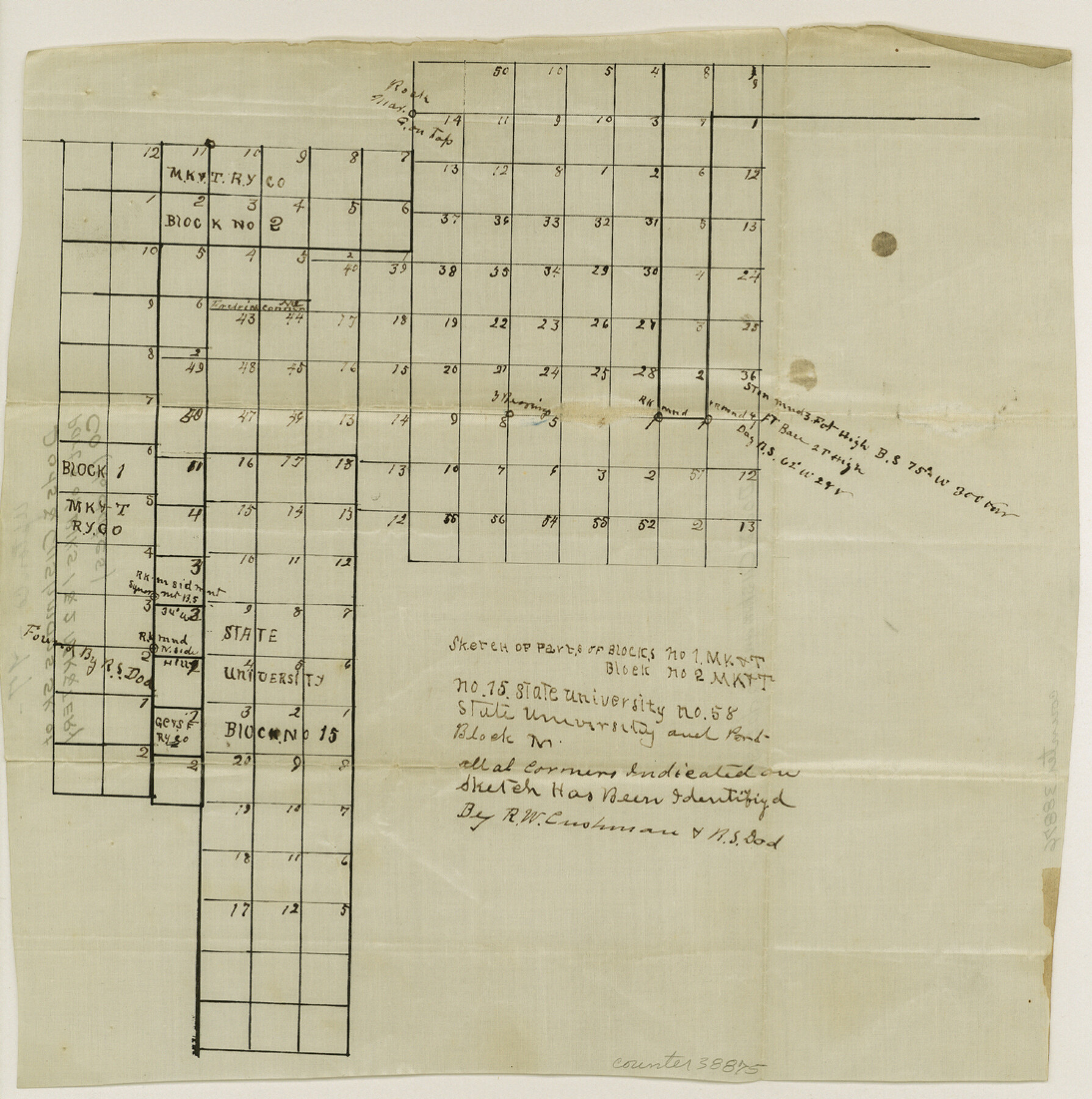
Upton County Sketch File 17
[Sketch of parts of Blocks 1 and 2, M. K. & T. E. RR. Co.]
-
Map/Doc
38875
-
Collection
General Map Collection
-
People and Organizations
Dod and Cushman (Surveyor/Engineer)
R.S. Dod (Surveyor/Engineer)
R.W. Cushman (Surveyor/Engineer)
-
Counties
Upton
-
Subjects
Surveying Sketch File
-
Height x Width
11.0 x 10.9 inches
27.9 x 27.7 cm
-
Medium
paper, manuscript
Part of: General Map Collection
Cooke County Sketch File 25

Print $4.00
- Digital $50.00
Cooke County Sketch File 25
1872
Size 8.2 x 6.8 inches
Map/Doc 19275
[McMullen and Live Oak County]
![10789, [McMullen and Live Oak County], General Map Collection](https://historictexasmaps.com/wmedia_w700/maps/10789.tif.jpg)
Print $20.00
- Digital $50.00
[McMullen and Live Oak County]
1870
Size 34.3 x 36.0 inches
Map/Doc 10789
Potter County

Print $20.00
- Digital $50.00
Potter County
1909
Size 47.5 x 40.8 inches
Map/Doc 66984
Upton County Rolled Sketch 24

Print $20.00
- Digital $50.00
Upton County Rolled Sketch 24
1886
Size 17.3 x 43.5 inches
Map/Doc 10043
Stonewall County Boundary File 4b

Print $18.00
- Digital $50.00
Stonewall County Boundary File 4b
Size 9.1 x 8.8 inches
Map/Doc 58993
King County Rolled Sketch 12

Print $20.00
- Digital $50.00
King County Rolled Sketch 12
1955
Size 40.9 x 45.7 inches
Map/Doc 9352
Flight Mission No. DQN-6K, Frame 12, Calhoun County

Print $20.00
- Digital $50.00
Flight Mission No. DQN-6K, Frame 12, Calhoun County
1953
Size 18.6 x 22.2 inches
Map/Doc 84434
Pecos County Sketch File 42

Print $30.00
- Digital $50.00
Pecos County Sketch File 42
1919
Size 9.1 x 8.0 inches
Map/Doc 33735
Right of Way and Track Map, Dayton-Goose Creek Ry. Co., Station 190+00 to Station 401+20

Print $40.00
- Digital $50.00
Right of Way and Track Map, Dayton-Goose Creek Ry. Co., Station 190+00 to Station 401+20
1917
Size 25.4 x 56.8 inches
Map/Doc 64366
Gulf of Mexico

Print $20.00
- Digital $50.00
Gulf of Mexico
1961
Size 36.6 x 43.3 inches
Map/Doc 73551

Eastland County Working Sketch 64

Print $40.00
- Digital $50.00
Eastland County Working Sketch 64
1983
Size 43.3 x 68.4 inches
Map/Doc 88891
You may also like
[Sketch showing topography in vicinity of Yellow Point]
![92137, [Sketch showing topography in vicinity of Yellow Point], Twichell Survey Records](https://historictexasmaps.com/wmedia_w700/maps/92137-1.tif.jpg)
Print $20.00
- Digital $50.00
[Sketch showing topography in vicinity of Yellow Point]
Size 21.4 x 19.2 inches
Map/Doc 92137
Flight Mission No. BRA-8M, Frame 81, Jefferson County

Print $20.00
- Digital $50.00
Flight Mission No. BRA-8M, Frame 81, Jefferson County
1953
Size 16.0 x 15.8 inches
Map/Doc 85601
Matagorda County NRC Article 33.136 Sketch 24

Print $78.00
Matagorda County NRC Article 33.136 Sketch 24
2025
Map/Doc 97509
Plat of Resurvey of Sections 5, 7 and 8, T. 5S., R. 14W. Indian Meridian, Oklahoma

Print $4.00
- Digital $50.00
Plat of Resurvey of Sections 5, 7 and 8, T. 5S., R. 14W. Indian Meridian, Oklahoma
1917
Size 18.5 x 22.6 inches
Map/Doc 75140
Reagan County Sketch File 3

Print $20.00
- Digital $50.00
Reagan County Sketch File 3
Size 18.0 x 21.9 inches
Map/Doc 12213
Val Verde County Working Sketch 87

Print $20.00
- Digital $50.00
Val Verde County Working Sketch 87
1973
Size 37.1 x 33.8 inches
Map/Doc 72222
Brewster County Rolled Sketch 114

Print $20.00
- Digital $50.00
Brewster County Rolled Sketch 114
1964
Size 11.6 x 17.3 inches
Map/Doc 5273
Kenedy County Sketch File 1

Print $68.00
- Digital $50.00
Kenedy County Sketch File 1
1950
Size 14.2 x 8.8 inches
Map/Doc 28739
Brewster County Rolled Sketch 122

Print $20.00
- Digital $50.00
Brewster County Rolled Sketch 122
1974
Size 31.9 x 24.6 inches
Map/Doc 5298
Gray County Working Sketch 7

Print $20.00
- Digital $50.00
Gray County Working Sketch 7
1971
Size 41.3 x 28.7 inches
Map/Doc 63238
Part of Laguna Madre in Kenedy and Willacy Counties, showing Subdivision for Mineral Development

Print $40.00
- Digital $50.00
Part of Laguna Madre in Kenedy and Willacy Counties, showing Subdivision for Mineral Development
1946
Size 49.1 x 30.0 inches
Map/Doc 1924
La Salle County Rolled Sketch 20

Print $20.00
- Digital $50.00
La Salle County Rolled Sketch 20
1954
Size 24.6 x 40.1 inches
Map/Doc 6584