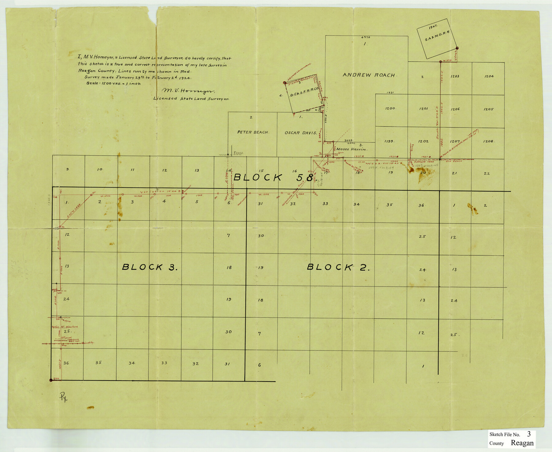
Reagan County Sketch File 3
[Blocks 3, 58 & 2, Reagan County, Texas]
-
Map/Doc
12213
-
Collection
General Map Collection
-
Object Dates
1924/2/5 (File Date)
-
People and Organizations
M.V. Homeyer (Surveyor/Engineer)
-
Counties
Reagan
-
Subjects
Surveying Sketch File
-
Height x Width
18.0 x 21.9 inches
45.7 x 55.6 cm
-
Medium
paper, manuscript
-
Features
Old Centralia Station Road
Stiles Road
Part of: General Map Collection
Flight Mission No. DCL-4C, Frame 7, Kenedy County

Print $20.00
- Digital $50.00
Flight Mission No. DCL-4C, Frame 7, Kenedy County
1943
Size 18.6 x 22.3 inches
Map/Doc 85808
Newton County Working Sketch 27

Print $20.00
- Digital $50.00
Newton County Working Sketch 27
1953
Size 25.9 x 30.0 inches
Map/Doc 71273
Presidio County Working Sketch 126

Print $20.00
- Digital $50.00
Presidio County Working Sketch 126
1987
Size 36.9 x 46.5 inches
Map/Doc 71804
Bastrop County Working Sketch 5

Print $20.00
- Digital $50.00
Bastrop County Working Sketch 5
1923
Size 14.3 x 19.5 inches
Map/Doc 67305
Foard County Sketch File 13

Print $6.00
- Digital $50.00
Foard County Sketch File 13
1885
Size 13.0 x 8.5 inches
Map/Doc 22816
Galveston County Aerial Photograph Index Sheet 5

Print $20.00
- Digital $50.00
Galveston County Aerial Photograph Index Sheet 5
1953
Size 23.1 x 18.8 inches
Map/Doc 83696
Map from the Sabine River to the Rio Grande as subdivided for mineral development

Print $20.00
- Digital $50.00
Map from the Sabine River to the Rio Grande as subdivided for mineral development
Size 30.6 x 44.8 inches
Map/Doc 65801
Shelby County

Print $20.00
- Digital $50.00
Shelby County
1945
Size 42.7 x 46.9 inches
Map/Doc 95639
Hudspeth County Rolled Sketch 14

Print $20.00
- Digital $50.00
Hudspeth County Rolled Sketch 14
1885
Size 17.1 x 35.9 inches
Map/Doc 9202
Sutton County Working Sketch 65

Print $20.00
- Digital $50.00
Sutton County Working Sketch 65
1963
Size 20.4 x 39.5 inches
Map/Doc 62408
Colorado County Sketch File 9

Print $3.00
- Digital $50.00
Colorado County Sketch File 9
Size 11.3 x 17.0 inches
Map/Doc 11134
Baylor County Working Sketch 3

Print $20.00
- Digital $50.00
Baylor County Working Sketch 3
1929
Size 37.8 x 36.5 inches
Map/Doc 67288
You may also like
Flight Mission No. CGI-3N, Frame 181, Cameron County

Print $20.00
- Digital $50.00
Flight Mission No. CGI-3N, Frame 181, Cameron County
1954
Size 18.5 x 22.2 inches
Map/Doc 84645
Kleberg County Rolled Sketch 10-16

Print $20.00
- Digital $50.00
Kleberg County Rolled Sketch 10-16
1952
Size 37.0 x 33.2 inches
Map/Doc 9381
Fayette County Sketch File 3

Print $6.00
- Digital $50.00
Fayette County Sketch File 3
1863
Size 8.3 x 10.7 inches
Map/Doc 22501
Flight Mission No. BRA-16M, Frame 168, Jefferson County

Print $20.00
- Digital $50.00
Flight Mission No. BRA-16M, Frame 168, Jefferson County
1953
Size 18.7 x 22.5 inches
Map/Doc 85766
Clay County Rolled Sketch 2

Print $20.00
- Digital $50.00
Clay County Rolled Sketch 2
1940
Size 35.9 x 26.8 inches
Map/Doc 5485
Stephens County Working Sketch 29

Print $20.00
- Digital $50.00
Stephens County Working Sketch 29
1977
Size 31.0 x 27.7 inches
Map/Doc 63972
Current Miscellaneous File 69

Print $10.00
- Digital $50.00
Current Miscellaneous File 69
1916
Size 11.2 x 8.8 inches
Map/Doc 74145
Kleberg County Rolled Sketch 10-1

Print $20.00
- Digital $50.00
Kleberg County Rolled Sketch 10-1
1951
Size 36.9 x 32.2 inches
Map/Doc 9383
Upton County Sketch File 40

Print $6.00
- Digital $50.00
Upton County Sketch File 40
1961
Size 11.5 x 8.7 inches
Map/Doc 38914
Val Verde County Sketch File 32

Print $20.00
- Digital $50.00
Val Verde County Sketch File 32
Size 45.1 x 20.1 inches
Map/Doc 10420
![91112, [Block 1], Twichell Survey Records](https://historictexasmaps.com/wmedia_w700/maps/91112-1.tif.jpg)
From Aransas Pass Eastward, Texas

Print $40.00
- Digital $50.00
From Aransas Pass Eastward, Texas
1866
Size 32.1 x 53.4 inches
Map/Doc 73427