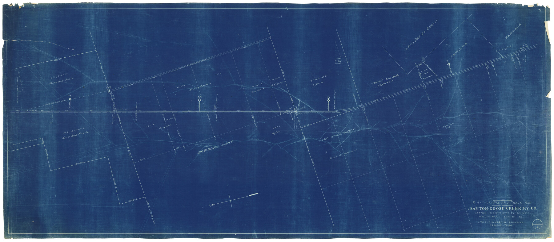
Right of Way and Track Map, Dayton-Goose Creek Ry. Co., Station 190+00 to Station 401+20
Z-2-94
-
Map/Doc
64366
-
Collection
General Map Collection
-
Object Dates
9/29/1917 (Creation Date)
-
People and Organizations
Howe and Wise (Publisher)
-
Counties
Chambers
-
Subjects
Railroads
-
Height x Width
25.4 x 56.8 inches
64.5 x 144.3 cm
-
Medium
blueprint/diazo
-
Scale
1 in. = 400 ft.
-
Comments
See counter nos. 64366 through 64368 for other sheets.
-
Features
DGC
Dayton Montbelvieu Road
Wood Bridge
Part of: General Map Collection
Brazoria County

Print $20.00
- Digital $50.00
Brazoria County
1873
Size 26.7 x 26.1 inches
Map/Doc 858
Irion County Rolled Sketch 9

Print $20.00
- Digital $50.00
Irion County Rolled Sketch 9
1940
Size 31.9 x 30.6 inches
Map/Doc 6321

San Augustine County Sketch File 10

Print $4.00
San Augustine County Sketch File 10
Size 12.8 x 8.1 inches
Map/Doc 35652
Cameron County Aerial Photograph Index Sheet 6

Print $20.00
- Digital $50.00
Cameron County Aerial Photograph Index Sheet 6
1940
Size 20.3 x 24.3 inches
Map/Doc 83682
Brewster County Sketch File N-3a

Print $40.00
- Digital $50.00
Brewster County Sketch File N-3a
Size 14.5 x 18.9 inches
Map/Doc 10962
Edwards County Sketch File 12

Print $16.00
- Digital $50.00
Edwards County Sketch File 12
Size 14.6 x 9.1 inches
Map/Doc 21690
Webb County Rolled Sketch 4

Print $20.00
- Digital $50.00
Webb County Rolled Sketch 4
Size 32.8 x 26.3 inches
Map/Doc 8171
Flight Mission No. CUG-3P, Frame 36, Kleberg County

Print $20.00
- Digital $50.00
Flight Mission No. CUG-3P, Frame 36, Kleberg County
1956
Size 18.4 x 22.1 inches
Map/Doc 86241
Reagan County Working Sketch 33
Print $40.00
- Digital $50.00
Reagan County Working Sketch 33
1965
Size 66.2 x 42.0 inches
Map/Doc 71875
Gaines County Sketch File 17

Print $32.00
- Digital $50.00
Gaines County Sketch File 17
1962
Size 11.3 x 8.8 inches
Map/Doc 23204
J. De Cordova's Map of the State of Texas Compiled from the records of the General Land Office of the State

Print $20.00
- Digital $50.00
J. De Cordova's Map of the State of Texas Compiled from the records of the General Land Office of the State
1851
Size 34.9 x 32.0 inches
Map/Doc 442
You may also like
[E. L. & R. R. RR. Co. Blocks 10 and 32, T. & P. R.R. Co. Blocks 30 and 31, Tsp 6N]
![90216, [E. L. & R. R. RR. Co. Blocks 10 and 32, T. & P. R.R. Co. Blocks 30 and 31, Tsp 6N], Twichell Survey Records](https://historictexasmaps.com/wmedia_w700/maps/90216-1.tif.jpg)
Print $20.00
- Digital $50.00
[E. L. & R. R. RR. Co. Blocks 10 and 32, T. & P. R.R. Co. Blocks 30 and 31, Tsp 6N]
Size 21.7 x 17.7 inches
Map/Doc 90216
Live Oak County Working Sketch 6

Print $20.00
- Digital $50.00
Live Oak County Working Sketch 6
1930
Size 17.6 x 21.6 inches
Map/Doc 70591

Johnson County Sketch File 25

Print $50.00
- Digital $50.00
Johnson County Sketch File 25
Size 13.9 x 8.3 inches
Map/Doc 28459
Texas, Corpus Christi Bay, Red Fish Bay to Nueces Bay

Print $40.00
- Digital $50.00
Texas, Corpus Christi Bay, Red Fish Bay to Nueces Bay
1934
Size 31.8 x 48.3 inches
Map/Doc 73459
Yoakum County

Print $20.00
- Digital $50.00
Yoakum County
1932
Size 47.1 x 35.6 inches
Map/Doc 63139
![88925, Map of Duval Co[unty], Library of Congress](https://historictexasmaps.com/wmedia_w700/maps/88925-1.tif.jpg)
Current Miscellaneous File 104

Print $8.00
- Digital $50.00
Current Miscellaneous File 104
1845
Size 11.0 x 16.8 inches
Map/Doc 74677
Ward County Working Sketch 38

Print $40.00
- Digital $50.00
Ward County Working Sketch 38
1969
Size 62.2 x 30.3 inches
Map/Doc 72344
Flight Mission No. CRC-4R, Frame 99, Chambers County

Print $20.00
- Digital $50.00
Flight Mission No. CRC-4R, Frame 99, Chambers County
1956
Size 18.5 x 22.2 inches
Map/Doc 84896
Flight Mission No. DQO-8K, Frame 74, Galveston County

Print $20.00
- Digital $50.00
Flight Mission No. DQO-8K, Frame 74, Galveston County
1952
Size 18.7 x 22.4 inches
Map/Doc 85178
General Highway Map, Victoria County, Texas

Print $20.00
General Highway Map, Victoria County, Texas
1961
Size 25.0 x 18.3 inches
Map/Doc 79697