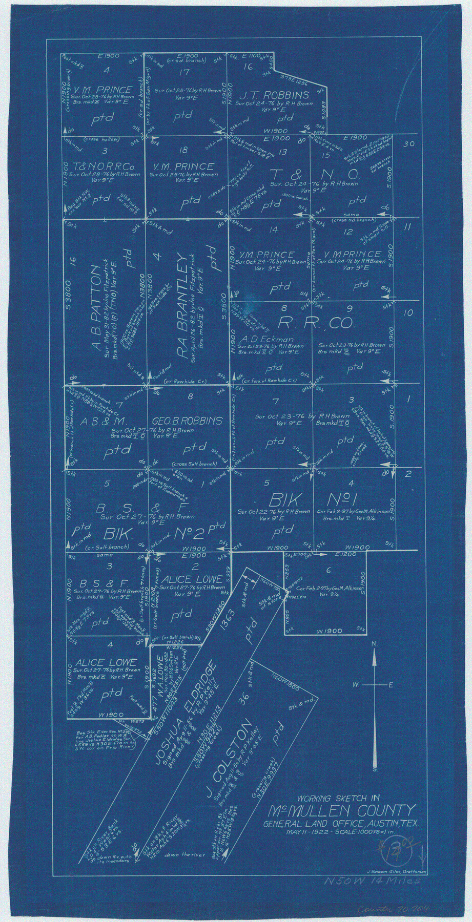
McMullen County Working Sketch 3
-
Map/Doc
70704
-
Collection
General Map Collection
-
Object Dates
5/11/1922 (Creation Date)
-
People and Organizations
J. Bascom Giles (Draftsman)
-
Counties
McMullen
-
Subjects
Surveying Working Sketch
-
Height x Width
21.1 x 10.8 inches
53.6 x 27.4 cm
-
Scale
1" = 1000 varas
Part of: General Map Collection
Maps of Gulf Intracoastal Waterway, Texas - Sabine River to the Rio Grande and connecting waterways including ship channels

Print $20.00
- Digital $50.00
Maps of Gulf Intracoastal Waterway, Texas - Sabine River to the Rio Grande and connecting waterways including ship channels
1966
Size 15.7 x 22.0 inches
Map/Doc 61985
Map of Bell County

Print $40.00
- Digital $50.00
Map of Bell County
1896
Size 48.1 x 54.4 inches
Map/Doc 82066
Andrews County Rolled Sketch 35

Print $20.00
- Digital $50.00
Andrews County Rolled Sketch 35
Size 21.5 x 16.1 inches
Map/Doc 77177
Jalisco Banco Number 67, cut from Mexico in 1909

Print $3.00
- Digital $50.00
Jalisco Banco Number 67, cut from Mexico in 1909
1912
Size 14.2 x 11.2 inches
Map/Doc 2064
Uvalde County Sketch File 29

Print $8.00
- Digital $50.00
Uvalde County Sketch File 29
1873
Size 13.0 x 8.3 inches
Map/Doc 39028
Plan of the City of Galveston, Texas

Print $20.00
- Digital $50.00
Plan of the City of Galveston, Texas
1845
Size 19.3 x 41.8 inches
Map/Doc 4665
Bailey County Rolled Sketch 3

Print $20.00
- Digital $50.00
Bailey County Rolled Sketch 3
1913
Size 15.2 x 13.8 inches
Map/Doc 5110
Trinity River, Waxahachie Sheet/Waxahachie Creek

Print $6.00
- Digital $50.00
Trinity River, Waxahachie Sheet/Waxahachie Creek
1931
Size 30.1 x 32.8 inches
Map/Doc 65237
Val Verde County Working Sketch 5

Print $20.00
- Digital $50.00
Val Verde County Working Sketch 5
1909
Size 13.0 x 29.8 inches
Map/Doc 72140
Surveys in the Milam District at the fork of the Yegua and Brazos Rivers and on the Leon River

Print $2.00
- Digital $50.00
Surveys in the Milam District at the fork of the Yegua and Brazos Rivers and on the Leon River
1846
Size 9.2 x 16.0 inches
Map/Doc 254
Hemphill County Rolled Sketch 11

Print $20.00
- Digital $50.00
Hemphill County Rolled Sketch 11
1941
Size 45.4 x 22.2 inches
Map/Doc 9152
Colorado County Sketch File 25

Print $8.00
- Digital $50.00
Colorado County Sketch File 25
1919
Size 11.5 x 8.8 inches
Map/Doc 18963
You may also like
Cooke County Working Sketch 24

Print $20.00
- Digital $50.00
Cooke County Working Sketch 24
1972
Size 22.1 x 24.4 inches
Map/Doc 68261
Williamson County Working Sketch 16

Print $20.00
- Digital $50.00
Williamson County Working Sketch 16
1984
Size 31.9 x 23.7 inches
Map/Doc 72576
McMullen County Working Sketch 21

Print $40.00
- Digital $50.00
McMullen County Working Sketch 21
1947
Size 38.3 x 53.4 inches
Map/Doc 70722
[Sections 69-84 Block 47 and part of Block 3]
![91795, [Sections 69-84 Block 47 and part of Block 3], Twichell Survey Records](https://historictexasmaps.com/wmedia_w700/maps/91795-1.tif.jpg)
Print $2.00
- Digital $50.00
[Sections 69-84 Block 47 and part of Block 3]
Size 14.3 x 8.9 inches
Map/Doc 91795
[Sketch along Garza-Kent County Line]
![89920, [Sketch along Garza-Kent County Line], Twichell Survey Records](https://historictexasmaps.com/wmedia_w700/maps/89920-1.tif.jpg)
Print $20.00
- Digital $50.00
[Sketch along Garza-Kent County Line]
Size 41.5 x 43.7 inches
Map/Doc 89920
[Surveys on the waters of Pine Creeke of the Neches]
![348, [Surveys on the waters of Pine Creeke of the Neches], General Map Collection](https://historictexasmaps.com/wmedia_w700/maps/348.tif.jpg)
Print $2.00
- Digital $50.00
[Surveys on the waters of Pine Creeke of the Neches]
1845
Size 7.9 x 8.2 inches
Map/Doc 348
Dickens County Sketch File O

Print $8.00
- Digital $50.00
Dickens County Sketch File O
1903
Size 13.3 x 8.7 inches
Map/Doc 20944
Aransas County Rolled Sketch 15C

Print $3.00
- Digital $50.00
Aransas County Rolled Sketch 15C
Size 10.2 x 17.6 inches
Map/Doc 76067
Lynn County, Texas

Print $20.00
- Digital $50.00
Lynn County, Texas
1883
Size 19.0 x 18.3 inches
Map/Doc 739
Edwards County Working Sketch 4

Print $20.00
- Digital $50.00
Edwards County Working Sketch 4
Size 28.7 x 28.3 inches
Map/Doc 68880
Sutton County Working Sketch 54

Print $20.00
- Digital $50.00
Sutton County Working Sketch 54
1957
Size 28.0 x 38.4 inches
Map/Doc 62397
Edwards County Working Sketch 135

Print $20.00
- Digital $50.00
Edwards County Working Sketch 135
1986
Size 31.8 x 38.4 inches
Map/Doc 69011