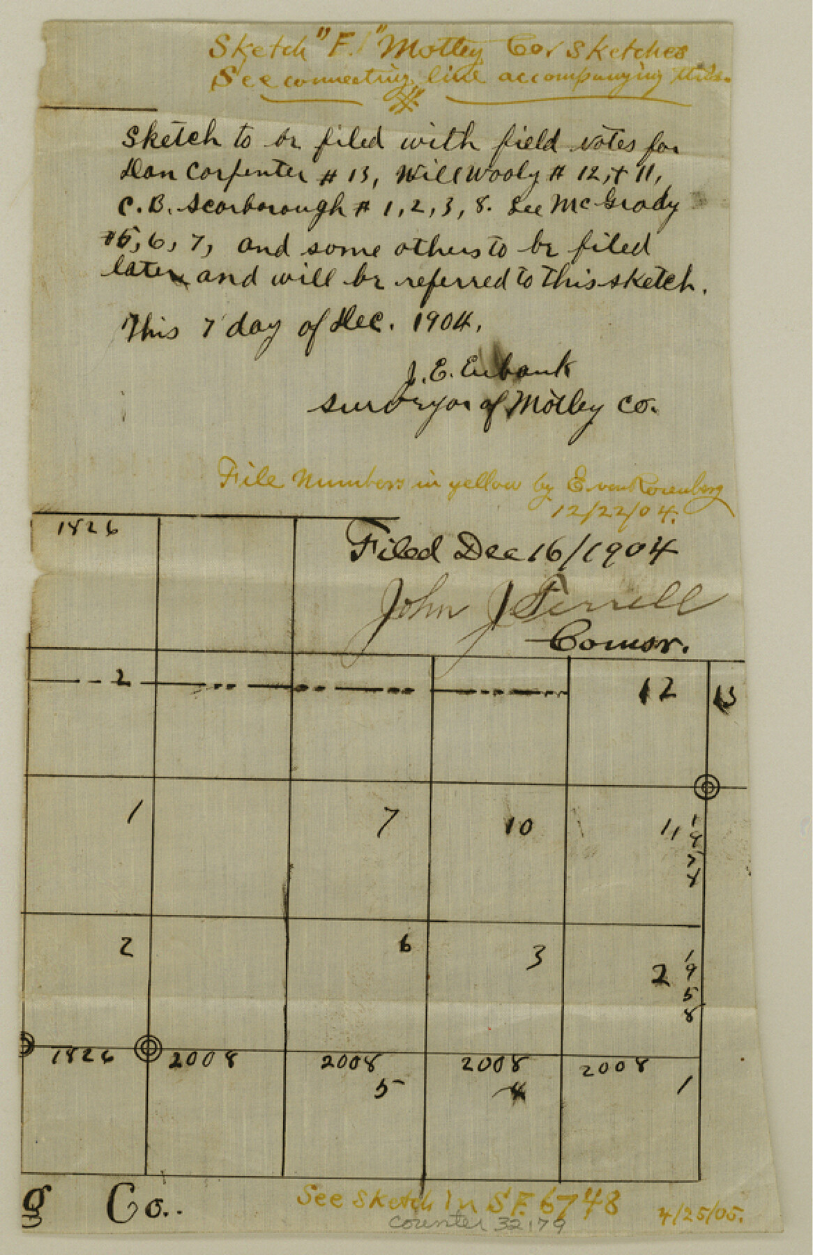
Motley County Sketch File F (S)
[Unlocated sketch, and report of survey in southeast portion of Motley County]
-
Map/Doc
32179
-
Collection
General Map Collection
-
Object Dates
12/16/1904 (File Date)
12/7/1904 (Creation Date)
8/23/1904 (Survey Date)
-
People and Organizations
J.E. Eubank (Surveyor/Engineer)
R.M. Kenney (Surveyor/Engineer)
Will Wooly (Chainman/Field Personnel)
Leander Carpenter (Chainman/Field Personnel)
-
Counties
Motley
-
Subjects
Surveying Sketch File
-
Height x Width
9.1 x 5.9 inches
23.1 x 15.0 cm
-
Medium
multi-page, multi-format
-
Features
Pease River
Paducah and Pitchfork Road
Buffalo Canyon
Cottonwood Creek
Part of: General Map Collection
Hunt County Sketch File 13

Print $2.00
- Digital $50.00
Hunt County Sketch File 13
1855
Size 12.4 x 8.1 inches
Map/Doc 27106
Gaines County Working Sketch 17

Print $20.00
- Digital $50.00
Gaines County Working Sketch 17
1964
Size 47.6 x 34.5 inches
Map/Doc 69317
[Surveys East of river copied from U.S. map of Township No. 6 South, Range No. 9 West of the Indian Meridian, Oklahoma]
![75186, [Surveys East of river copied from U.S. map of Township No. 6 South, Range No. 9 West of the Indian Meridian, Oklahoma], General Map Collection](https://historictexasmaps.com/wmedia_w700/maps/75186.tif.jpg)
Print $2.00
- Digital $50.00
[Surveys East of river copied from U.S. map of Township No. 6 South, Range No. 9 West of the Indian Meridian, Oklahoma]
Size 13.3 x 9.2 inches
Map/Doc 75186
Presidio County Rolled Sketch 61

Print $20.00
- Digital $50.00
Presidio County Rolled Sketch 61
1914
Size 16.0 x 19.7 inches
Map/Doc 7353
Flight Mission No. BQR-3K, Frame 155, Brazoria County

Print $20.00
- Digital $50.00
Flight Mission No. BQR-3K, Frame 155, Brazoria County
1952
Size 18.7 x 22.4 inches
Map/Doc 83982
Sutton County Working Sketch Graphic Index, Sheet 1 (Sketches 1 to 24)

Print $40.00
- Digital $50.00
Sutton County Working Sketch Graphic Index, Sheet 1 (Sketches 1 to 24)
1941
Size 41.9 x 55.3 inches
Map/Doc 76705
Kimble County Working Sketch 4

Print $20.00
- Digital $50.00
Kimble County Working Sketch 4
1913
Size 26.8 x 21.7 inches
Map/Doc 70072
Presidio County Rolled Sketch 140

Print $20.00
- Digital $50.00
Presidio County Rolled Sketch 140
2003
Size 44.4 x 34.7 inches
Map/Doc 78654
Sutton County Boundary File 5a

Print $20.00
- Digital $50.00
Sutton County Boundary File 5a
Size 14.5 x 8.9 inches
Map/Doc 59060
[Galveston, Harrisburg & San Antonio through El Paso County]
![64010, [Galveston, Harrisburg & San Antonio through El Paso County], General Map Collection](https://historictexasmaps.com/wmedia_w700/maps/64010.tif.jpg)
Print $20.00
- Digital $50.00
[Galveston, Harrisburg & San Antonio through El Paso County]
1906
Size 13.4 x 33.9 inches
Map/Doc 64010
Crockett County Rolled Sketch 88E

Print $40.00
- Digital $50.00
Crockett County Rolled Sketch 88E
1973
Size 44.4 x 30.6 inches
Map/Doc 8730
Ward County Working Sketch 39

Print $20.00
- Digital $50.00
Ward County Working Sketch 39
1969
Size 24.2 x 45.5 inches
Map/Doc 72345
You may also like
Flight Mission No. DQO-8K, Frame 90, Galveston County

Print $20.00
- Digital $50.00
Flight Mission No. DQO-8K, Frame 90, Galveston County
1952
Size 17.9 x 22.3 inches
Map/Doc 85192

Guadalupe County Sketch File 11

Print $4.00
- Digital $50.00
Guadalupe County Sketch File 11
Size 8.0 x 12.8 inches
Map/Doc 24681
Reeves County Working Sketch 65

Print $20.00
- Digital $50.00
Reeves County Working Sketch 65
1990
Size 17.3 x 19.7 inches
Map/Doc 63508
Polk County Sketch File 2a

Print $4.00
- Digital $50.00
Polk County Sketch File 2a
1863
Size 12.2 x 8.1 inches
Map/Doc 34120
Flight Mission No. BRE-2P, Frame 47, Nueces County

Print $20.00
- Digital $50.00
Flight Mission No. BRE-2P, Frame 47, Nueces County
1956
Size 18.6 x 22.6 inches
Map/Doc 86749
[Bastrop County School Land Leagues 313 and 314, Thos. H. Cosby League 315 and El Paso County School Land League 316 and surrounding surveys]
![90819, [Bastrop County School Land Leagues 313 and 314, Thos. H. Cosby League 315 and El Paso County School Land League 316 and surrounding surveys], Twichell Survey Records](https://historictexasmaps.com/wmedia_w700/maps/90819-2.tif.jpg)
Print $3.00
- Digital $50.00
[Bastrop County School Land Leagues 313 and 314, Thos. H. Cosby League 315 and El Paso County School Land League 316 and surrounding surveys]
1898
Size 10.5 x 12.6 inches
Map/Doc 90819
Harris County Rolled Sketch 88

Print $20.00
- Digital $50.00
Harris County Rolled Sketch 88
1935
Size 34.4 x 23.0 inches
Map/Doc 6121
Chambers County Sketch File 42

Print $149.00
- Digital $50.00
Chambers County Sketch File 42
1917
Size 14.3 x 8.8 inches
Map/Doc 17700
Madison County Rolled Sketch 1A

Print $20.00
- Digital $50.00
Madison County Rolled Sketch 1A
1966
Size 36.1 x 45.5 inches
Map/Doc 9486
General Highway Map. Detail of Cities and Towns in Dallas County, Texas [Dallas and vicinity]
![79435, General Highway Map. Detail of Cities and Towns in Dallas County, Texas [Dallas and vicinity], Texas State Library and Archives](https://historictexasmaps.com/wmedia_w700/maps/79435.tif.jpg)
Print $20.00
General Highway Map. Detail of Cities and Towns in Dallas County, Texas [Dallas and vicinity]
1961
Size 18.2 x 24.6 inches
Map/Doc 79435
Menard County

Print $20.00
- Digital $50.00
Menard County
1942
Size 43.6 x 47.7 inches
Map/Doc 77371