Sherman County Rolled Sketch 5
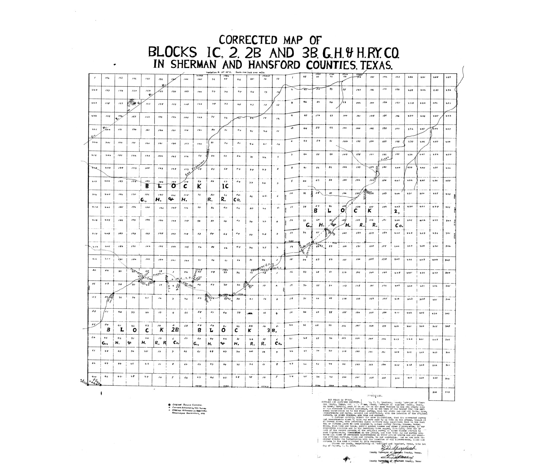
Corrected map of Blocks 1C, 2, 2B, and 3B, G. H. & H. Ry. Co. in Sherman and Hansford Counties, Texas
- 
                          Map/Doc9928
- 
                            CollectionGeneral Map Collection
- 
                            Object Dates1919/8/1 (Creation Date)1919/8/21 (File Date)
- 
                            People and OrganizationsH.E. James (Surveyor/Engineer)D.D. Spurlock (Surveyor/Engineer)
- 
                            CountiesSherman Hansford
- 
                            SubjectsSurveying Rolled Sketch
- 
                            Height x Width36.9 x 41.4 inches93.7 x 105.2 cm
- 
                            Scale1" = 1 mile
Related maps
            Sherman County Sketch File B


                                            Print $6.00                    
                                             -                         Digital $50.00                                    
                Sherman County Sketch File B
1919
Size 14.4 x 8.8 inches
                                Map/Doc 36691
            Part of: General Map Collection
            Dallam County Working Sketch Graphic Index


                                            Print $40.00                    
                                             -                         Digital $50.00                                    
                Dallam County Working Sketch Graphic Index
1926
Size 41.3 x 50.9 inches
                                Map/Doc 76516
            
            Young County Working Sketch 10


                                            Print $20.00                    
                                             -                         Digital $50.00                                    
                Young County Working Sketch 10
1921
Size 24.4 x 34.4 inches
                                Map/Doc 62033
            
            In the Supreme Court of the United States The State of Oklahoma, Complainant vs. The State of Texas, Defendant, The United States of America, Intervener - 1920


                                            Print $20.00                    
                                             -                         Digital $50.00                                    
                In the Supreme Court of the United States The State of Oklahoma, Complainant vs. The State of Texas, Defendant, The United States of America, Intervener - 1920
1920
Size 39.4 x 35.7 inches
                                Map/Doc 75264
            
            Val Verde County Sketch File Z5


                                            Print $20.00                    
                                             -                         Digital $50.00                                    
                Val Verde County Sketch File Z5
Size 32.3 x 26.1 inches
                                Map/Doc 12551
            
            Bee County Sketch File 10


                                            Print $4.00                    
                                             -                         Digital $50.00                                    
                Bee County Sketch File 10
Size 12.8 x 7.9 inches
                                Map/Doc 14291
            
            Laguna Madre from Lone Palmetto Triangulation Station to Gum Pen Triangulation Station


                                            Print $40.00                    
                                             -                         Digital $50.00                                    
                Laguna Madre from Lone Palmetto Triangulation Station to Gum Pen Triangulation Station
1881
Size 33.1 x 54.7 inches
                                Map/Doc 73495
            
            Childress County Working Sketch 5


                                            Print $20.00                    
                                             -                         Digital $50.00                                    
                Childress County Working Sketch 5
1948
Size 19.6 x 23.5 inches
                                Map/Doc 68021
            
            Van Zandt County Sketch File 49


                                            Print $2.00                    
                                             -                         Digital $50.00                                    
                Van Zandt County Sketch File 49
1990
Size 11.3 x 8.9 inches
                                Map/Doc 39510
            
            Flight Mission No. CGI-3N, Frame 139, Cameron County


                                            Print $20.00                    
                                             -                         Digital $50.00                                    
                Flight Mission No. CGI-3N, Frame 139, Cameron County
1954
Size 18.7 x 22.3 inches
                                Map/Doc 84612
            
            Controlled Mosaic by Jack Amman Photogrammetric Engineers, Inc - Sheet 18


                                            Print $20.00                    
                                             -                         Digital $50.00                                    
                Controlled Mosaic by Jack Amman Photogrammetric Engineers, Inc - Sheet 18
1954
Size 19.4 x 24.0 inches
                                Map/Doc 83463
            
            Kent County Sketch File 9


                                            Print $8.00                    
                                             -                         Digital $50.00                                    
                Kent County Sketch File 9
Size 10.3 x 8.1 inches
                                Map/Doc 28832
            
            Tyler County Working Sketch 20


                                            Print $20.00                    
                                             -                         Digital $50.00                                    
                Tyler County Working Sketch 20
1982
Size 41.0 x 32.7 inches
                                Map/Doc 69490
            You may also like
            Map of Orange County, Texas


                                            Print $20.00                    
                                             -                         Digital $50.00                                    
                Map of Orange County, Texas
1880
Size 15.6 x 19.1 inches
                                Map/Doc 746
            
            Flight Mission No. CRC-3R, Frame 52, Chambers County


                                            Print $20.00                    
                                             -                         Digital $50.00                                    
                Flight Mission No. CRC-3R, Frame 52, Chambers County
1956
Size 18.7 x 22.3 inches
                                Map/Doc 89041
            
            Current Miscellaneous File 16


                                            Print $20.00                    
                                             -                         Digital $50.00                                    
                Current Miscellaneous File 16
1951
Size 10.7 x 8.2 inches
                                Map/Doc 73830
            
            [H. & T. C. Block 47]
            
                                    ![91834, [H. & T. C. Block 47], Twichell Survey Records](https://historictexasmaps.com/wmedia_w700/maps/91834-1.tif.jpg) 


    ![91834, [H. & T. C. Block 47], Twichell Survey Records](https://historictexasmaps.com/wmedia_w700/maps/91834-1.tif.jpg) 
                                
            
                                            Print $20.00                    
                                             -                         Digital $50.00                                    
                [H. & T. C. Block 47]
Size 19.4 x 18.5 inches
                                Map/Doc 91834
            
            Map of Texas with population and location of principal towns and cities according to latest reliable statistics


                                            Print $20.00                    
                                             -                         Digital $50.00                                    
                Map of Texas with population and location of principal towns and cities according to latest reliable statistics
1910
Size 19.1 x 20.6 inches
                                Map/Doc 95878
            
            Hardin County Rolled Sketch 21


                                            Print $20.00                    
                                             -                         Digital $50.00                                    
                Hardin County Rolled Sketch 21
1966
Size 18.8 x 22.7 inches
                                Map/Doc 6090
            
            Denton County Working Sketch Graphic Index


                                            Print $20.00                    
                                             -                         Digital $50.00                                    
                Denton County Working Sketch Graphic Index
1947
Size 41.5 x 38.5 inches
                                Map/Doc 76521
            
            Jack County Sketch File 34


                                            Print $20.00                    
                                             -                         Digital $50.00                                    
                Jack County Sketch File 34
1951
Size 21.2 x 29.3 inches
                                Map/Doc 11832
            
            Jefferson County Working Sketch 38


                                            Print $20.00                    
                                             -                         Digital $50.00                                    
                Jefferson County Working Sketch 38
1984
Size 32.6 x 43.2 inches
                                Map/Doc 66582
            
            Tom Green County Sketch File 1


                                            Print $4.00                    
                                             -                         Digital $50.00                                    
                Tom Green County Sketch File 1
Size 8.1 x 12.7 inches
                                Map/Doc 38159
            
            Uvalde County Rolled Sketch 12


                                            Print $20.00                    
                                             -                         Digital $50.00                                    
                Uvalde County Rolled Sketch 12
1971
Size 28.5 x 40.4 inches
                                Map/Doc 8097
            
            Photostat of section of hydrographic surveys H-5399, H-4822, H-470


                                            Print $20.00                    
                                             -                         Digital $50.00                                    
                Photostat of section of hydrographic surveys H-5399, H-4822, H-470
1933
Size 25.9 x 18.3 inches
                                Map/Doc 61158
            