Stephens County Sketch File 9a
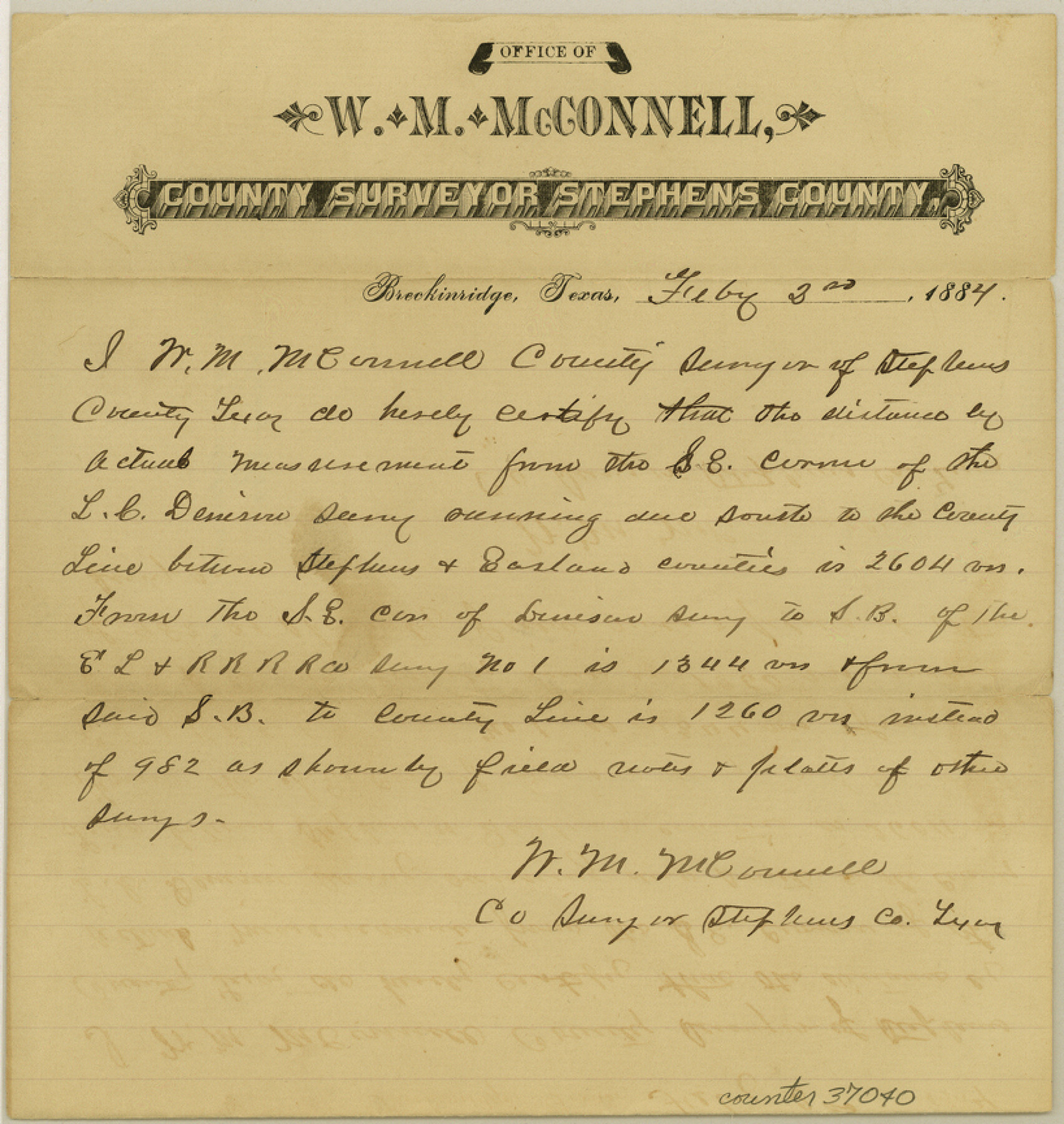
[Statement regarding distances between L.C. Dennison and surrounding surveys]
-
Map/Doc
37040
-
Collection
General Map Collection
-
Object Dates
2/2/1884 (Creation Date)
2/8/1884 (File Date)
-
People and Organizations
W.M. McConnell (Surveyor/Engineer)
-
Counties
Stephens
-
Subjects
Surveying Sketch File
-
Height x Width
8.6 x 8.2 inches
21.8 x 20.8 cm
-
Medium
paper, manuscript
Part of: General Map Collection
Falls County Boundary File 3

Print $15.00
- Digital $50.00
Falls County Boundary File 3
Size 8.6 x 3.8 inches
Map/Doc 53266
Kinney County Working Sketch 35

Print $40.00
- Digital $50.00
Kinney County Working Sketch 35
1965
Size 58.3 x 48.6 inches
Map/Doc 70217
Brewster County Rolled Sketch 101

Print $20.00
- Digital $50.00
Brewster County Rolled Sketch 101
1944
Size 34.6 x 42.4 inches
Map/Doc 8924
Flight Mission No. BRA-16M, Frame 100, Jefferson County

Print $20.00
- Digital $50.00
Flight Mission No. BRA-16M, Frame 100, Jefferson County
1953
Size 18.4 x 19.2 inches
Map/Doc 85712
Potter County Boundary File 3b

Print $12.00
- Digital $50.00
Potter County Boundary File 3b
Size 9.8 x 6.4 inches
Map/Doc 57979
Parker County Working Sketch 23

Print $20.00
- Digital $50.00
Parker County Working Sketch 23
2007
Map/Doc 87924
Armstrong County Boundary File 4

Print $2.00
- Digital $50.00
Armstrong County Boundary File 4
Size 10.2 x 8.8 inches
Map/Doc 50148
Flight Mission No. BRA-16M, Frame 164, Jefferson County

Print $20.00
- Digital $50.00
Flight Mission No. BRA-16M, Frame 164, Jefferson County
1953
Size 18.7 x 22.3 inches
Map/Doc 85762
[Surveys along the Guadalupe River and Blanco Creek]
![45, [Surveys along the Guadalupe River and Blanco Creek], General Map Collection](https://historictexasmaps.com/wmedia_w700/maps/45.tif.jpg)
Print $20.00
- Digital $50.00
[Surveys along the Guadalupe River and Blanco Creek]
Size 19.5 x 15.7 inches
Map/Doc 45
Comanche County Sketch File 5

Print $4.00
- Digital $50.00
Comanche County Sketch File 5
1848
Size 8.6 x 8.3 inches
Map/Doc 19059
Limestone Co.

Print $40.00
- Digital $50.00
Limestone Co.
1887
Size 52.1 x 33.8 inches
Map/Doc 16881

You may also like
Flight Mission No. DAG-24K, Frame 128, Matagorda County

Print $20.00
- Digital $50.00
Flight Mission No. DAG-24K, Frame 128, Matagorda County
1953
Size 17.2 x 22.5 inches
Map/Doc 86546
[Part of Wichita County in the vicinity of Elizabeth Stanley survey 812 and W. M. Rivers survey 810]
![91971, [Part of Wichita County in the vicinity of Elizabeth Stanley survey 812 and W. M. Rivers survey 810], Twichell Survey Records](https://historictexasmaps.com/wmedia_w700/maps/91971-1.tif.jpg)
Print $3.00
- Digital $50.00
[Part of Wichita County in the vicinity of Elizabeth Stanley survey 812 and W. M. Rivers survey 810]
1920
Size 11.5 x 11.7 inches
Map/Doc 91971
Eastland County Working Sketch 65

Print $20.00
- Digital $50.00
Eastland County Working Sketch 65
1986
Size 37.4 x 16.5 inches
Map/Doc 88892
Crosby County Working Sketch 1

Print $20.00
- Digital $50.00
Crosby County Working Sketch 1
Size 28.0 x 26.0 inches
Map/Doc 68435
Brewster County Working Sketch 9

Print $20.00
- Digital $50.00
Brewster County Working Sketch 9
1910
Size 14.3 x 14.4 inches
Map/Doc 67542
Crane County Map of Unsurveyed School Lands for Bob Reid's Application to Lease

Print $40.00
- Digital $50.00
Crane County Map of Unsurveyed School Lands for Bob Reid's Application to Lease
1946
Size 49.0 x 51.3 inches
Map/Doc 90466
Newton County Sketch File 27

Print $4.00
- Digital $50.00
Newton County Sketch File 27
Size 13.0 x 8.6 inches
Map/Doc 32411
Flight Mission No. BRE-2P, Frame 17, Nueces County

Print $20.00
- Digital $50.00
Flight Mission No. BRE-2P, Frame 17, Nueces County
1956
Size 18.2 x 22.1 inches
Map/Doc 86726
Mitchell County

Print $20.00
- Digital $50.00
Mitchell County
1889
Size 42.3 x 35.7 inches
Map/Doc 10792
San Jacinto River, Buff Lake Sheet 2/Caney Creek

Print $4.00
- Digital $50.00
San Jacinto River, Buff Lake Sheet 2/Caney Creek
1937
Size 24.1 x 24.7 inches
Map/Doc 65148
Corpus Christi Pass, Texas

Print $20.00
- Digital $50.00
Corpus Christi Pass, Texas
1871
Size 26.1 x 18.3 inches
Map/Doc 72981
Henderson County Rolled Sketch 11

Print $20.00
- Digital $50.00
Henderson County Rolled Sketch 11
1915
Size 29.2 x 42.9 inches
Map/Doc 76149