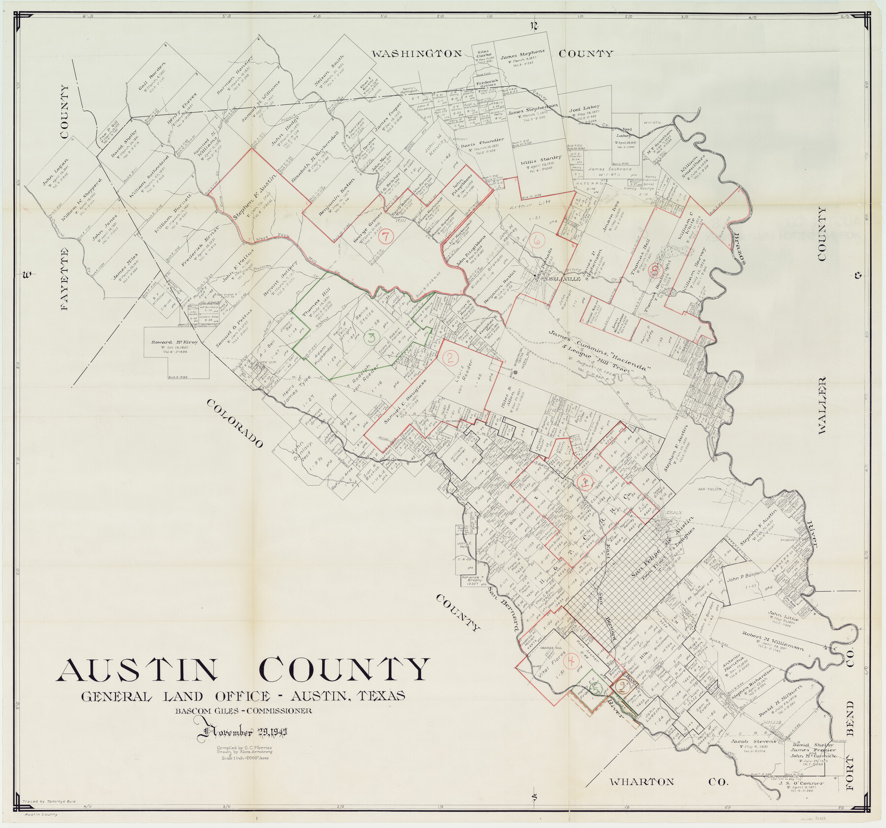
Austin County Working Sketch Graphic Index
-
Map/Doc
76459
-
Collection
General Map Collection
-
Object Dates
11/29/1943 (Creation Date)
-
People and Organizations
G.C. Morriss (Compiler)
Eltea Armstrong (Draftsman)
-
Counties
Austin
-
Subjects
County Surveying Working Sketch
-
Height x Width
38.6 x 41.1 inches
98.0 x 104.4 cm
-
Scale
1" = 2000 varas
Part of: General Map Collection
Jackson County Sketch File 29

Print $10.00
- Digital $50.00
Jackson County Sketch File 29
Size 13.4 x 8.7 inches
Map/Doc 27725
Wichita County Working Sketch 6

Print $20.00
- Digital $50.00
Wichita County Working Sketch 6
1919
Size 24.6 x 21.4 inches
Map/Doc 72515
Nueces County NRC Article 33.136 Sketch 12

Print $80.00
- Digital $50.00
Nueces County NRC Article 33.136 Sketch 12
2000
Size 24.9 x 36.7 inches
Map/Doc 83065
Deaf Smith County Sketch File D(a)

Print $30.00
- Digital $50.00
Deaf Smith County Sketch File D(a)
1905
Size 9.4 x 8.8 inches
Map/Doc 20643
Flight Mission No. CLL-1N, Frame 32, Willacy County

Print $20.00
- Digital $50.00
Flight Mission No. CLL-1N, Frame 32, Willacy County
1954
Size 17.5 x 19.4 inches
Map/Doc 87013
Topographical Map of the Rio Grande, Sheet No. 20

Print $20.00
- Digital $50.00
Topographical Map of the Rio Grande, Sheet No. 20
1912
Map/Doc 89544
Laguna Madre from Lone Palmetto Triangulation Station to Gum Pen Triangulation Station

Print $40.00
- Digital $50.00
Laguna Madre from Lone Palmetto Triangulation Station to Gum Pen Triangulation Station
1881
Size 33.1 x 54.7 inches
Map/Doc 73495
Bowie County Sketch File 8

Print $42.00
- Digital $50.00
Bowie County Sketch File 8
1927
Size 8.9 x 3.8 inches
Map/Doc 14872
Flight Mission No. BQR-9K, Frame 48, Brazoria County

Print $20.00
- Digital $50.00
Flight Mission No. BQR-9K, Frame 48, Brazoria County
1952
Size 18.7 x 22.2 inches
Map/Doc 84052
Galveston Entrance

Print $20.00
- Digital $50.00
Galveston Entrance
1925
Size 18.5 x 24.1 inches
Map/Doc 69859
Map of the City of Corsicana (Navarro County) Texas

Print $40.00
- Digital $50.00
Map of the City of Corsicana (Navarro County) Texas
1963
Size 43.2 x 92.3 inches
Map/Doc 93673
Flight Mission No. CRE-2R, Frame 82, Jackson County

Print $20.00
- Digital $50.00
Flight Mission No. CRE-2R, Frame 82, Jackson County
1956
Size 16.0 x 15.9 inches
Map/Doc 85354
You may also like
Nueces County Rolled Sketch 73

Print $20.00
- Digital $50.00
Nueces County Rolled Sketch 73
1981
Size 24.2 x 36.0 inches
Map/Doc 6931
Edwards County Working Sketch 29

Print $40.00
- Digital $50.00
Edwards County Working Sketch 29
1946
Size 44.9 x 53.9 inches
Map/Doc 68905
Flight Mission No. DAG-17K, Frame 60, Matagorda County

Print $20.00
- Digital $50.00
Flight Mission No. DAG-17K, Frame 60, Matagorda County
1952
Size 18.5 x 22.3 inches
Map/Doc 86322
Presidio County Sketch File 121

Print $57.00
- Digital $50.00
Presidio County Sketch File 121
1998
Size 11.0 x 8.5 inches
Map/Doc 82620
Denton County Working Sketch 26

Print $20.00
- Digital $50.00
Denton County Working Sketch 26
1995
Size 29.3 x 33.9 inches
Map/Doc 68631
Cooke County Working Sketch 11

Print $20.00
- Digital $50.00
Cooke County Working Sketch 11
1940
Size 42.6 x 28.2 inches
Map/Doc 68248
Hamilton County Map

Print $40.00
- Digital $50.00
Hamilton County Map
1887
Size 38.2 x 54.4 inches
Map/Doc 16844
Brewster County Sketch File N-2

Print $44.00
- Digital $50.00
Brewster County Sketch File N-2
1881
Size 8.2 x 12.8 inches
Map/Doc 15567
The Chief Justice County of Harrisburg. Lands in Conflict with Brazoria, Liberty Counties

Print $20.00
The Chief Justice County of Harrisburg. Lands in Conflict with Brazoria, Liberty Counties
2020
Size 17.5 x 21.7 inches
Map/Doc 96050
[Sketch for Mineral Application 16696-16697, Pecos River]
![65612, [Sketch for Mineral Application 16696-16697, Pecos River], General Map Collection](https://historictexasmaps.com/wmedia_w700/maps/65612-1.tif.jpg)
Print $40.00
- Digital $50.00
[Sketch for Mineral Application 16696-16697, Pecos River]
Size 37.4 x 74.9 inches
Map/Doc 65612
DeWitt County Working Sketch 5

Print $20.00
- Digital $50.00
DeWitt County Working Sketch 5
1977
Size 34.6 x 36.8 inches
Map/Doc 68595
Kerr County Sketch File 12

Print $4.00
- Digital $50.00
Kerr County Sketch File 12
1901
Size 6.7 x 11.1 inches
Map/Doc 28881