Bailey County Sketch File B
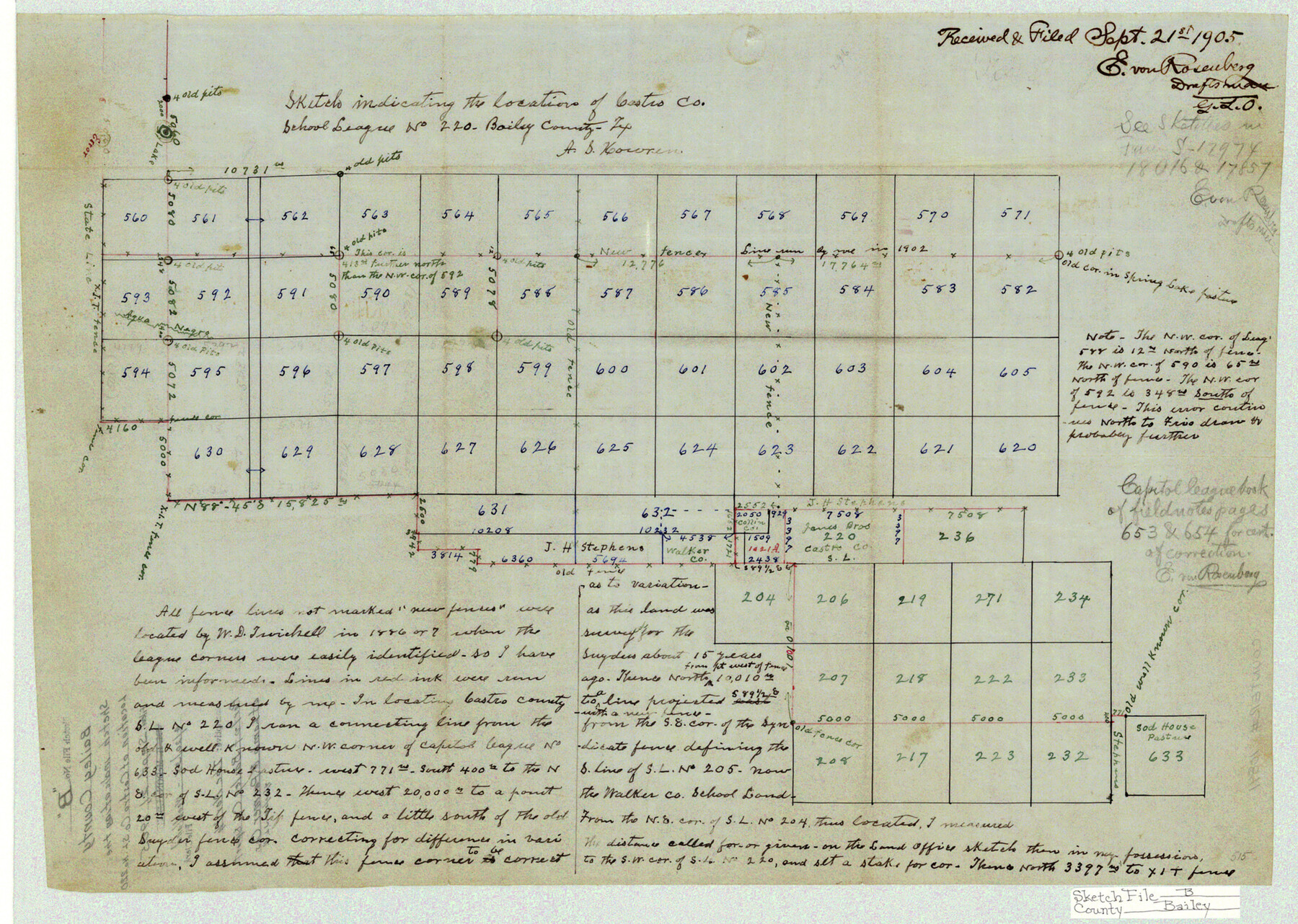
Sketch indicating the location of Castro Co. School League no. 220, Bailey County, Tex.
-
Map/Doc
10891
-
Collection
General Map Collection
-
Object Dates
1905/9/21 (File Date)
-
People and Organizations
A.S. Howren (Surveyor/Engineer)
-
Counties
Bailey Lamb Parmer
-
Subjects
Surveying Sketch File
-
Height x Width
14.5 x 20.4 inches
36.8 x 51.8 cm
-
Medium
linen, manuscript
-
Features
Agua Negra
Part of: General Map Collection
Kleberg County Rolled Sketch 10-41

Print $20.00
- Digital $50.00
Kleberg County Rolled Sketch 10-41
1952
Size 41.2 x 32.7 inches
Map/Doc 9385
Young County Working Sketch 15

Print $20.00
- Digital $50.00
Young County Working Sketch 15
1952
Size 13.7 x 18.0 inches
Map/Doc 62038
McMullen County Working Sketch 27

Print $40.00
- Digital $50.00
McMullen County Working Sketch 27
1953
Size 53.2 x 32.9 inches
Map/Doc 70728
Duval County Boundary File 5

Print $4.00
- Digital $50.00
Duval County Boundary File 5
Size 7.7 x 11.9 inches
Map/Doc 52769
Parker County Sketch File 28

Print $6.00
- Digital $50.00
Parker County Sketch File 28
1876
Size 15.7 x 10.2 inches
Map/Doc 33568
Kendall County Working Sketch 27

Print $20.00
- Digital $50.00
Kendall County Working Sketch 27
1994
Size 30.8 x 42.6 inches
Map/Doc 66699
Jack County Sketch File 16a

Print $4.00
- Digital $50.00
Jack County Sketch File 16a
1885
Size 8.3 x 11.8 inches
Map/Doc 27551
Galveston County Working Sketch 17

Print $20.00
- Digital $50.00
Galveston County Working Sketch 17
1982
Size 15.5 x 14.3 inches
Map/Doc 69354
Newton County Rolled Sketch 25

Print $20.00
- Digital $50.00
Newton County Rolled Sketch 25
1893
Size 17.1 x 21.4 inches
Map/Doc 6854
La Salle County Working Sketch 9

Print $20.00
- Digital $50.00
La Salle County Working Sketch 9
1925
Size 21.2 x 15.6 inches
Map/Doc 70310
Donley County Sketch File B10

Print $24.00
- Digital $50.00
Donley County Sketch File B10
1938
Size 14.3 x 9.1 inches
Map/Doc 21272
Map of the Republic of Texas Shewing [sic] its division into Counties and Latest Improvements to 1837
![476, Map of the Republic of Texas Shewing [sic] its division into Counties and Latest Improvements to 1837, General Map Collection](https://historictexasmaps.com/wmedia_w700/maps/476-1.tif.jpg)
Print $20.00
- Digital $50.00
Map of the Republic of Texas Shewing [sic] its division into Counties and Latest Improvements to 1837
1837
Size 28.2 x 23.0 inches
Map/Doc 476
You may also like
Travis County Boundary File 2

Print $42.00
- Digital $50.00
Travis County Boundary File 2
Size 9.3 x 7.2 inches
Map/Doc 59406
Hardin County Working Sketch 5

Print $20.00
- Digital $50.00
Hardin County Working Sketch 5
1921
Size 31.0 x 22.0 inches
Map/Doc 63403
Flight Mission No. CUG-1P, Frame 79, Kleberg County

Print $20.00
- Digital $50.00
Flight Mission No. CUG-1P, Frame 79, Kleberg County
1956
Size 18.7 x 22.2 inches
Map/Doc 86144
Jackson County Boundary File 3

Print $10.00
- Digital $50.00
Jackson County Boundary File 3
Size 10.9 x 8.7 inches
Map/Doc 55455
Baylor County Working Sketch 12

Print $20.00
- Digital $50.00
Baylor County Working Sketch 12
1960
Size 27.3 x 21.6 inches
Map/Doc 67297
Hamilton County Working Sketch 2

Print $20.00
- Digital $50.00
Hamilton County Working Sketch 2
1923
Size 12.9 x 15.7 inches
Map/Doc 63340
Cameron County Rolled Sketch 32

Print $40.00
- Digital $50.00
Cameron County Rolled Sketch 32
1981
Size 136.6 x 18.1 inches
Map/Doc 8579
Travis County Sketch File 3

Print $4.00
- Digital $50.00
Travis County Sketch File 3
Size 12.9 x 7.9 inches
Map/Doc 38273
Mrs. Minnie Slaughter Veal's Subdivision of C. C. Slaughter Cattle Co. Division, Cochran County, Texas

Print $20.00
- Digital $50.00
Mrs. Minnie Slaughter Veal's Subdivision of C. C. Slaughter Cattle Co. Division, Cochran County, Texas
Size 26.6 x 20.5 inches
Map/Doc 90296
Panola County Working Sketch 27

Print $20.00
- Digital $50.00
Panola County Working Sketch 27
1956
Map/Doc 71436
Hardin County Rolled Sketch 5

Print $20.00
- Digital $50.00
Hardin County Rolled Sketch 5
1937
Size 21.5 x 18.8 inches
Map/Doc 6078
Briscoe County Rolled Sketch 16

Print $20.00
- Digital $50.00
Briscoe County Rolled Sketch 16
1934
Size 17.8 x 19.9 inches
Map/Doc 5330