Bailey County Sketch File B

Print $40.00
- Digital $50.00
Bailey County Sketch File B
Size: 14.5 x 20.4 inches
10891
Castro County Sketch File 2

Print $20.00
- Digital $50.00
Castro County Sketch File 2
Size: 24.7 x 17.7 inches
11057
Deaf Smith County Sketch File E

Print $20.00
- Digital $50.00
Deaf Smith County Sketch File E
Size: 22.3 x 12.9 inches
11308
Parmer County Sketch File 3

Print $20.00
- Digital $50.00
Parmer County Sketch File 3
1905
Size: 17.2 x 14.4 inches
12153
Map of Parmer County

Print $20.00
- Digital $50.00
Map of Parmer County
1900
Size: 47.8 x 41.3 inches
16786
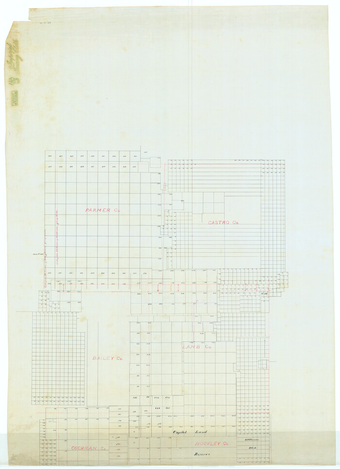
[Map Showing Parmer, Castro, Bailey, Lamb, Cochran & Hockley Counties, Texas]
Print $40.00
- Digital $50.00
[Map Showing Parmer, Castro, Bailey, Lamb, Cochran & Hockley Counties, Texas]
1910
Size: 55.3 x 40.1 inches
1762
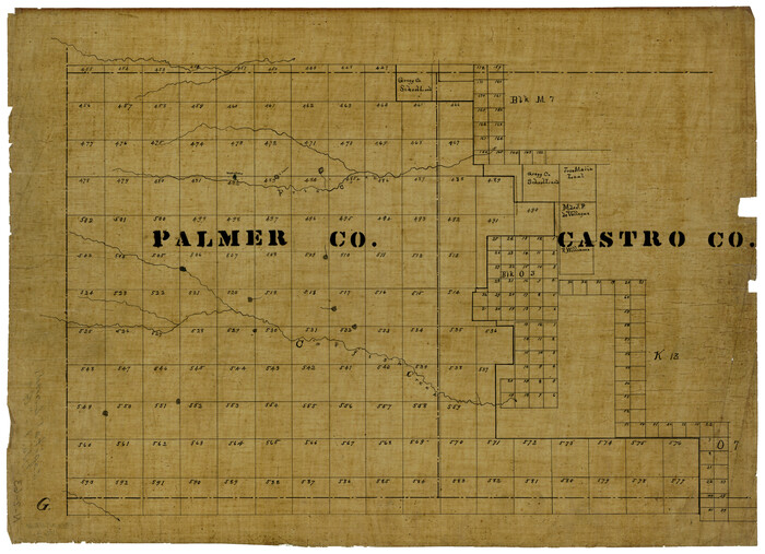
[Palmer and Castro Counties]
Print $20.00
- Digital $50.00
[Palmer and Castro Counties]
1910
Size: 19.3 x 26.3 inches
1763
Deaf Smith County Sketch File 1b

Print $24.00
- Digital $50.00
Deaf Smith County Sketch File 1b
1902
Size: 11.3 x 8.9 inches
20627
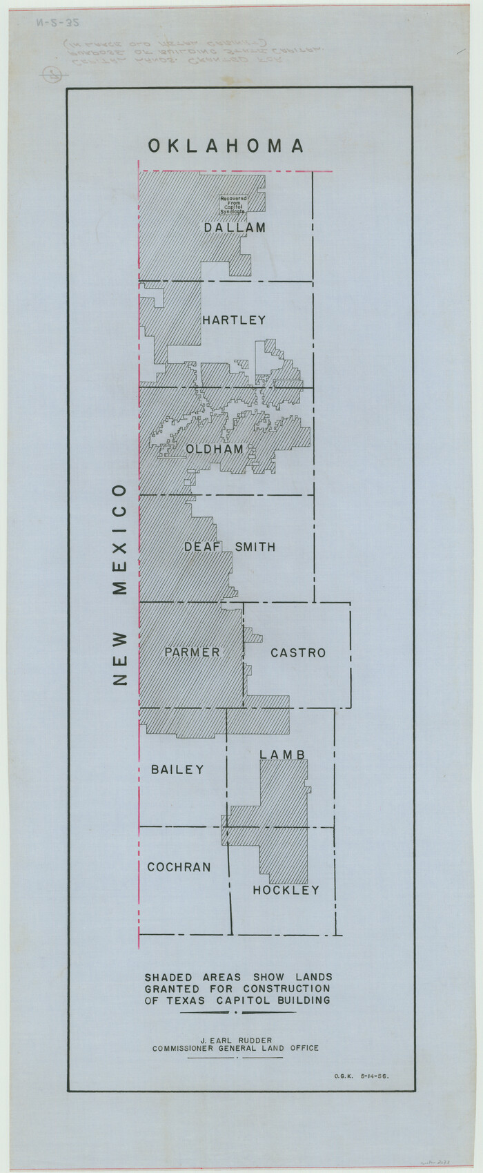
[Capitol lands granted for purpose of building State Capitol]
Print $20.00
- Digital $50.00
[Capitol lands granted for purpose of building State Capitol]
1956
Size: 31.5 x 13.0 inches
2073
Parmer County Sketch File 1

Print $28.00
- Digital $50.00
Parmer County Sketch File 1
1902
Size: 10.6 x 8.2 inches
33621
Parmer County Sketch File 2

Print $26.00
- Digital $50.00
Parmer County Sketch File 2
1903
Size: 7.2 x 8.7 inches
33626
Parmer County Sketch File 4

Print $44.00
- Digital $50.00
Parmer County Sketch File 4
1913
Size: 7.1 x 8.6 inches
33630
Castro County Rolled Sketch 13

Print $20.00
- Digital $50.00
Castro County Rolled Sketch 13
1967
Size: 18.7 x 20.1 inches
5422
Castro County Rolled Sketch 13A

Print $20.00
- Digital $50.00
Castro County Rolled Sketch 13A
1967
Size: 20.0 x 18.9 inches
5423
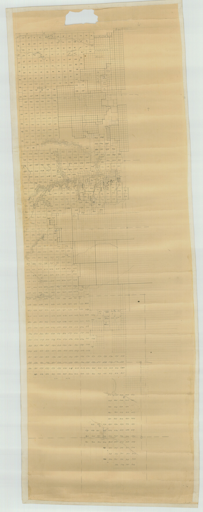
[Capitol Lands in Dallam, Hartley, Oldham, Deaf Smith, Parmer, Bailey, Lamb, Cochran, Castro, and Hockley Counties]
Print $40.00
- Digital $50.00
[Capitol Lands in Dallam, Hartley, Oldham, Deaf Smith, Parmer, Bailey, Lamb, Cochran, Castro, and Hockley Counties]
Size: 55.4 x 22.0 inches
60295
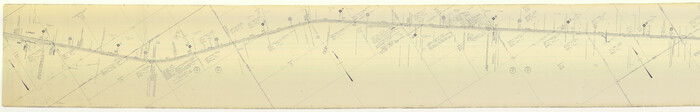
Map of Location of the Pecos & Northern Texas Railway from Station 5868+52 to Station 7879+36 = 38.08 Miles through Parmer County, Texas

Print $40.00
- Digital $50.00
Map of Location of the Pecos & Northern Texas Railway from Station 5868+52 to Station 7879+36 = 38.08 Miles through Parmer County, Texas
Size: 20.2 x 108.5 inches
64090
[Pecos and Northern Texas Ry., Bailey Co., from Parmer Co. line through Lariat and Muleshoe to Lamb Co. line]
Print $40.00
- Digital $50.00
[Pecos and Northern Texas Ry., Bailey Co., from Parmer Co. line through Lariat and Muleshoe to Lamb Co. line]
1912
Size: 19.5 x 121.6 inches
64635
Deaf Smith County Working Sketch 2

Print $20.00
- Digital $50.00
Deaf Smith County Working Sketch 2
1926
Size: 42.3 x 33.1 inches
68642
Deaf Smith County Working Sketch 3

Print $40.00
- Digital $50.00
Deaf Smith County Working Sketch 3
1951
Size: 61.4 x 22.3 inches
68643
Parmer County Working Sketch 1

Print $20.00
- Digital $50.00
Parmer County Working Sketch 1
1903
71469
Parmer County Working Sketch 2

Print $20.00
- Digital $50.00
Parmer County Working Sketch 2
1914
71470
Parmer County Working Sketch Graphic Index

Print $20.00
- Digital $50.00
Parmer County Working Sketch Graphic Index
1926
76662
General Highway Map, Parmer County, Texas

Print $20.00
General Highway Map, Parmer County, Texas
1940
Size: 18.3 x 24.6 inches
79216
General Highway Map, Parmer County, Texas

Print $20.00
General Highway Map, Parmer County, Texas
1961
Size: 18.1 x 24.4 inches
79626
Castro County Rolled Sketch 14

Print $20.00
- Digital $50.00
Castro County Rolled Sketch 14
1965
Size: 47.6 x 43.5 inches
8608
Bailey County Sketch File B
Print $40.00
- Digital $50.00
Bailey County Sketch File B
-
Size
14.5 x 20.4 inches
-
Map/Doc
10891
Castro County Sketch File 2
Print $20.00
- Digital $50.00
Castro County Sketch File 2
-
Size
24.7 x 17.7 inches
-
Map/Doc
11057
Deaf Smith County Sketch File E
Print $20.00
- Digital $50.00
Deaf Smith County Sketch File E
-
Size
22.3 x 12.9 inches
-
Map/Doc
11308
Parmer County Sketch File 3
Print $20.00
- Digital $50.00
Parmer County Sketch File 3
1905
-
Size
17.2 x 14.4 inches
-
Map/Doc
12153
-
Creation Date
1905
Map of Parmer County
Print $20.00
- Digital $50.00
Map of Parmer County
1900
-
Size
47.8 x 41.3 inches
-
Map/Doc
16786
-
Creation Date
1900
[Map Showing Parmer, Castro, Bailey, Lamb, Cochran & Hockley Counties, Texas]
Print $40.00
- Digital $50.00
[Map Showing Parmer, Castro, Bailey, Lamb, Cochran & Hockley Counties, Texas]
1910
-
Size
55.3 x 40.1 inches
-
Map/Doc
1762
-
Creation Date
1910
[Palmer and Castro Counties]
Print $20.00
- Digital $50.00
[Palmer and Castro Counties]
1910
-
Size
19.3 x 26.3 inches
-
Map/Doc
1763
-
Creation Date
1910
Deaf Smith County Sketch File 1b
Print $24.00
- Digital $50.00
Deaf Smith County Sketch File 1b
1902
-
Size
11.3 x 8.9 inches
-
Map/Doc
20627
-
Creation Date
1902
[Capitol lands granted for purpose of building State Capitol]
Print $20.00
- Digital $50.00
[Capitol lands granted for purpose of building State Capitol]
1956
-
Size
31.5 x 13.0 inches
-
Map/Doc
2073
-
Creation Date
1956
Parmer County Sketch File 1
Print $28.00
- Digital $50.00
Parmer County Sketch File 1
1902
-
Size
10.6 x 8.2 inches
-
Map/Doc
33621
-
Creation Date
1902
Parmer County Sketch File 2
Print $26.00
- Digital $50.00
Parmer County Sketch File 2
1903
-
Size
7.2 x 8.7 inches
-
Map/Doc
33626
-
Creation Date
1903
Parmer County Sketch File 4
Print $44.00
- Digital $50.00
Parmer County Sketch File 4
1913
-
Size
7.1 x 8.6 inches
-
Map/Doc
33630
-
Creation Date
1913
Parmer County

Print $20.00
- Digital $50.00
Parmer County
1884
-
Size
19.8 x 18.3 inches
-
Map/Doc
3949
-
Creation Date
1884
Parmer County

Print $20.00
- Digital $50.00
Parmer County
1884
-
Size
20.1 x 18.6 inches
-
Map/Doc
4612
-
Creation Date
1884
Castro County Rolled Sketch 13
Print $20.00
- Digital $50.00
Castro County Rolled Sketch 13
1967
-
Size
18.7 x 20.1 inches
-
Map/Doc
5422
-
Creation Date
1967
Castro County Rolled Sketch 13A
Print $20.00
- Digital $50.00
Castro County Rolled Sketch 13A
1967
-
Size
20.0 x 18.9 inches
-
Map/Doc
5423
-
Creation Date
1967
[Capitol Lands in Dallam, Hartley, Oldham, Deaf Smith, Parmer, Bailey, Lamb, Cochran, Castro, and Hockley Counties]
Print $40.00
- Digital $50.00
[Capitol Lands in Dallam, Hartley, Oldham, Deaf Smith, Parmer, Bailey, Lamb, Cochran, Castro, and Hockley Counties]
-
Size
55.4 x 22.0 inches
-
Map/Doc
60295
Map of Location of the Pecos & Northern Texas Railway from Station 5868+52 to Station 7879+36 = 38.08 Miles through Parmer County, Texas
Print $40.00
- Digital $50.00
Map of Location of the Pecos & Northern Texas Railway from Station 5868+52 to Station 7879+36 = 38.08 Miles through Parmer County, Texas
-
Size
20.2 x 108.5 inches
-
Map/Doc
64090
[Pecos and Northern Texas Ry., Bailey Co., from Parmer Co. line through Lariat and Muleshoe to Lamb Co. line]
Print $40.00
- Digital $50.00
[Pecos and Northern Texas Ry., Bailey Co., from Parmer Co. line through Lariat and Muleshoe to Lamb Co. line]
1912
-
Size
19.5 x 121.6 inches
-
Map/Doc
64635
-
Creation Date
1912
Parmer County

Print $20.00
- Digital $50.00
Parmer County
1926
-
Size
46.2 x 36.5 inches
-
Map/Doc
66973
-
Creation Date
1926
Deaf Smith County Working Sketch 2
Print $20.00
- Digital $50.00
Deaf Smith County Working Sketch 2
1926
-
Size
42.3 x 33.1 inches
-
Map/Doc
68642
-
Creation Date
1926
Deaf Smith County Working Sketch 3
Print $40.00
- Digital $50.00
Deaf Smith County Working Sketch 3
1951
-
Size
61.4 x 22.3 inches
-
Map/Doc
68643
-
Creation Date
1951
Parmer County Working Sketch 1
Print $20.00
- Digital $50.00
Parmer County Working Sketch 1
1903
-
Map/Doc
71469
-
Creation Date
1903
Parmer County Working Sketch 2
Print $20.00
- Digital $50.00
Parmer County Working Sketch 2
1914
-
Map/Doc
71470
-
Creation Date
1914
Parmer County

Print $20.00
- Digital $50.00
Parmer County
1926
-
Size
43.9 x 35.4 inches
-
Map/Doc
73259
-
Creation Date
1926
Parmer County Working Sketch Graphic Index
Print $20.00
- Digital $50.00
Parmer County Working Sketch Graphic Index
1926
-
Map/Doc
76662
-
Creation Date
1926
Parmer County

Print $20.00
- Digital $50.00
Parmer County
1926
-
Size
39.8 x 31.6 inches
-
Map/Doc
77392
-
Creation Date
1926
General Highway Map, Parmer County, Texas
Print $20.00
General Highway Map, Parmer County, Texas
1940
-
Size
18.3 x 24.6 inches
-
Map/Doc
79216
-
Creation Date
1940
General Highway Map, Parmer County, Texas
Print $20.00
General Highway Map, Parmer County, Texas
1961
-
Size
18.1 x 24.4 inches
-
Map/Doc
79626
-
Creation Date
1961
Castro County Rolled Sketch 14
Print $20.00
- Digital $50.00
Castro County Rolled Sketch 14
1965
-
Size
47.6 x 43.5 inches
-
Map/Doc
8608
-
Creation Date
1965