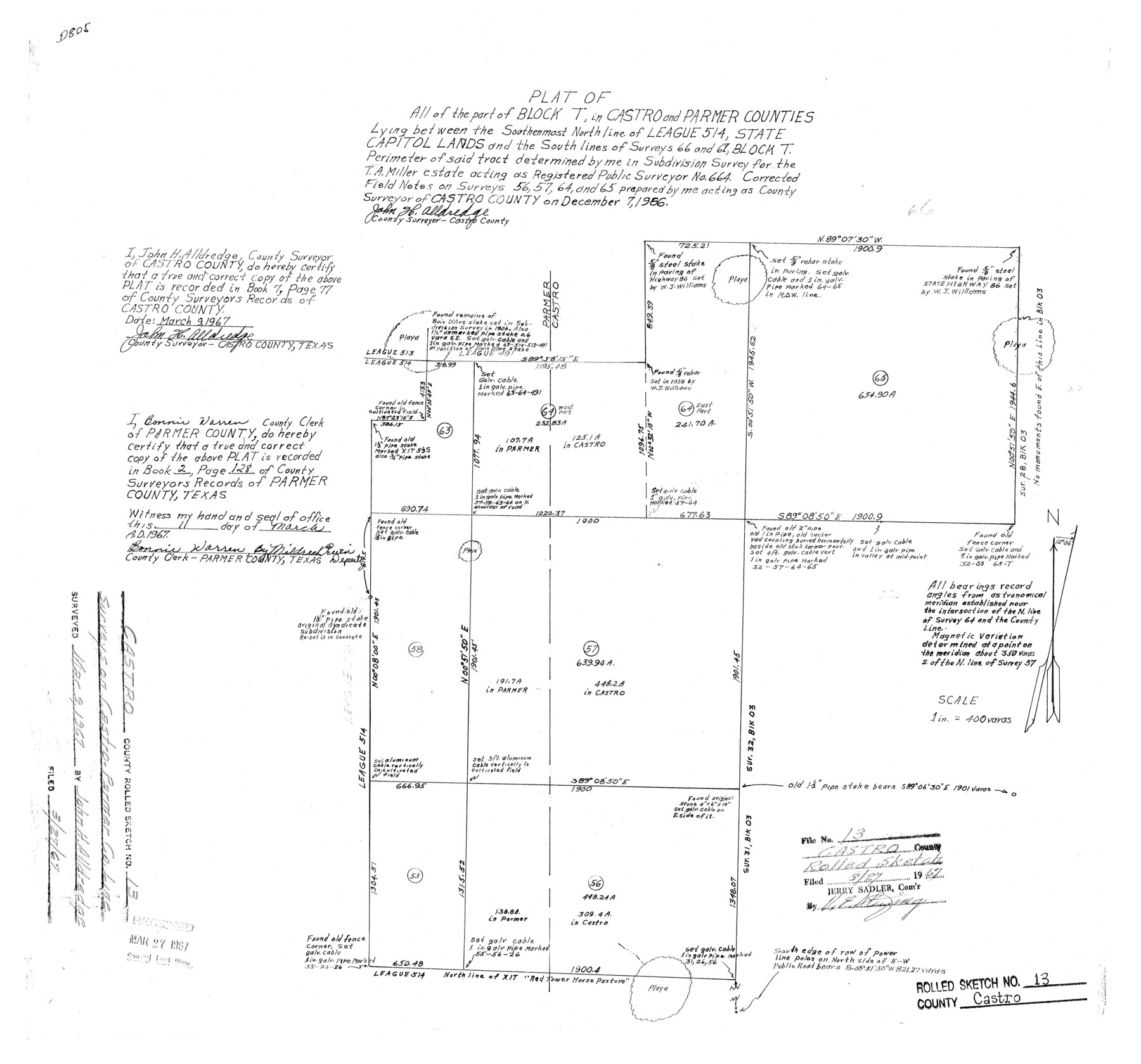
Castro County Rolled Sketch 13
Plat of all of the part of Block T, in Castro and Parmer Counties lying between the southernmost north line of League 514, State Capitol Lands and the south lines of surveys 66 and 67, Block T
-
Map/Doc
5422
-
Collection
General Map Collection
-
Object Dates
1967/3/9 (Creation Date)
1967/3/27 (File Date)
1966/12/7 (Survey Date)
-
People and Organizations
John H. Alldredge (Surveyor/Engineer)
-
Counties
Castro Parmer
-
Subjects
Surveying Rolled Sketch
-
Height x Width
18.7 x 20.1 inches
47.5 x 51.1 cm
-
Scale
1" = 400 varas
Part of: General Map Collection
Menard County Boundary File 6

Print $6.00
- Digital $50.00
Menard County Boundary File 6
Size 11.2 x 8.7 inches
Map/Doc 57086
Eastland County Rolled Sketch B

Print $20.00
- Digital $50.00
Eastland County Rolled Sketch B
1893
Size 27.7 x 40.9 inches
Map/Doc 5774
Flight Mission No. DQO-3K, Frame 30, Galveston County

Print $20.00
- Digital $50.00
Flight Mission No. DQO-3K, Frame 30, Galveston County
1952
Size 18.9 x 22.4 inches
Map/Doc 85071
Tyler County Sketch File 5

Print $20.00
- Digital $50.00
Tyler County Sketch File 5
1854
Size 13.2 x 17.4 inches
Map/Doc 12497
Upton County Sketch File 8

Print $4.00
- Digital $50.00
Upton County Sketch File 8
1913
Size 14.4 x 8.8 inches
Map/Doc 38822
Aransas County Rolled Sketch 1

Print $40.00
- Digital $50.00
Aransas County Rolled Sketch 1
1930
Size 54.3 x 17.0 inches
Map/Doc 8914
Robertson Co.

Print $20.00
- Digital $50.00
Robertson Co.
1945
Size 47.9 x 39.0 inches
Map/Doc 63004
Cameron County Rolled Sketch 18

Print $64.00
- Digital $50.00
Cameron County Rolled Sketch 18
1970
Size 48.9 x 57.1 inches
Map/Doc 8571
Garza County Sketch File 5

Print $14.00
- Digital $50.00
Garza County Sketch File 5
1885
Size 9.8 x 8.1 inches
Map/Doc 24050
[Sketch for Mineral Application 33721 - 33725 Incl. - Padre and Mustang Island]
![2868, [Sketch for Mineral Application 33721 - 33725 Incl. - Padre and Mustang Island], General Map Collection](https://historictexasmaps.com/wmedia_w700/maps/2868.tif.jpg)
Print $20.00
- Digital $50.00
[Sketch for Mineral Application 33721 - 33725 Incl. - Padre and Mustang Island]
1942
Size 29.7 x 22.3 inches
Map/Doc 2868
Blanco County Rolled Sketch 13

Print $20.00
- Digital $50.00
Blanco County Rolled Sketch 13
Size 14.2 x 28.9 inches
Map/Doc 5149
Jones County Working Sketch 6

Print $20.00
- Digital $50.00
Jones County Working Sketch 6
1951
Size 36.2 x 20.6 inches
Map/Doc 66644
You may also like
Nueces County Rolled Sketch 84

Print $20.00
- Digital $50.00
Nueces County Rolled Sketch 84
1982
Size 18.1 x 24.7 inches
Map/Doc 6970
Pecos County Working Sketch 48

Print $20.00
- Digital $50.00
Pecos County Working Sketch 48
1947
Size 35.0 x 27.7 inches
Map/Doc 71520
Hutchinson County Sketch File 33

Print $20.00
- Digital $50.00
Hutchinson County Sketch File 33
1926
Size 26.5 x 24.5 inches
Map/Doc 11821
Matagorda County Sketch File 43

Print $20.00
- Digital $50.00
Matagorda County Sketch File 43
1839
Size 13.2 x 8.2 inches
Map/Doc 30868
Wilbarger County Sketch File 5a

Print $20.00
- Digital $50.00
Wilbarger County Sketch File 5a
Size 13.4 x 19.7 inches
Map/Doc 12690
Kimble County Working Sketch 40

Print $40.00
- Digital $50.00
Kimble County Working Sketch 40
1948
Size 53.0 x 38.4 inches
Map/Doc 70108
Moxley-McWhorter Irrigated Farm

Print $20.00
- Digital $50.00
Moxley-McWhorter Irrigated Farm
1946
Size 27.5 x 15.8 inches
Map/Doc 92338
Lamar County Sketch File 16

Print $166.00
- Digital $50.00
Lamar County Sketch File 16
2013
Size 11.0 x 8.5 inches
Map/Doc 93654
Paul Bennett Farm

Print $20.00
- Digital $50.00
Paul Bennett Farm
Size 18.7 x 21.5 inches
Map/Doc 92409
Fort Bend County Working Sketch 14

Print $20.00
- Digital $50.00
Fort Bend County Working Sketch 14
1948
Size 37.4 x 32.7 inches
Map/Doc 69220
Reeves County Sketch File 5

Print $20.00
- Digital $50.00
Reeves County Sketch File 5
Size 16.1 x 33.4 inches
Map/Doc 12241
Hutchinson County Rolled Sketch 8

Print $20.00
- Digital $50.00
Hutchinson County Rolled Sketch 8
Size 32.0 x 29.1 inches
Map/Doc 6279