Upton County Sketch File 8
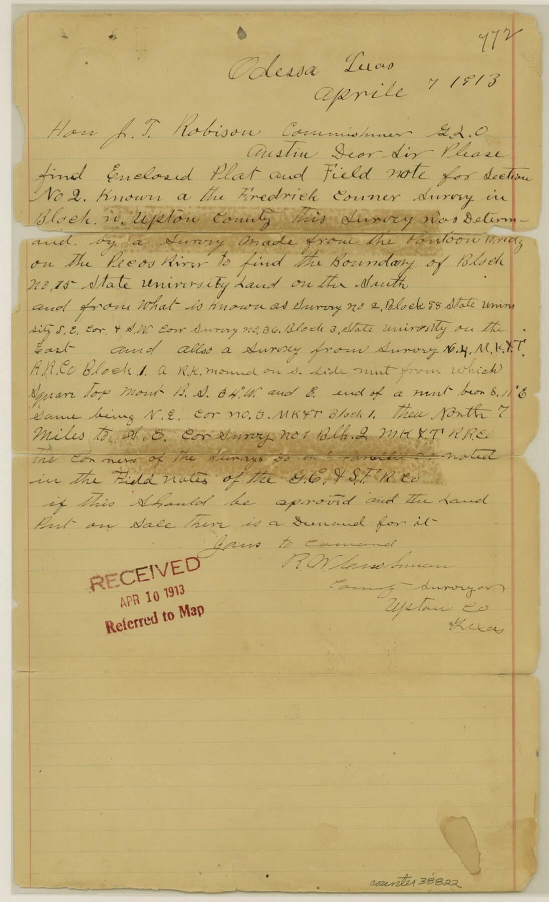
[Letter regarding section 2, Block N]
-
Map/Doc
38822
-
Collection
General Map Collection
-
Object Dates
1913/4/7 (Creation Date)
1913/4/10 (File Date)
1913/4/7 (Creation Date)
1913/4/7 (Correspondence Date)
1913/4/10 (File Date)
-
People and Organizations
R.W. Cushman (Surveyor/Engineer)
-
Counties
Upton
-
Subjects
Surveying Sketch File
-
Height x Width
14.4 x 8.8 inches
36.6 x 22.4 cm
-
Medium
paper, manuscript
-
Features
Pontoon Bridge
Pecos River
Part of: General Map Collection
Fractional Township No. 8 South Range No. 7 East of the Indian Meridian, Indian Territory

Print $20.00
- Digital $50.00
Fractional Township No. 8 South Range No. 7 East of the Indian Meridian, Indian Territory
1898
Size 19.2 x 24.3 inches
Map/Doc 75213
Flight Mission No. DCL-4C, Frame 4, Kenedy County

Print $20.00
- Digital $50.00
Flight Mission No. DCL-4C, Frame 4, Kenedy County
1943
Size 18.7 x 22.3 inches
Map/Doc 85805
Kent County Sketch File 1

Print $6.00
- Digital $50.00
Kent County Sketch File 1
1882
Size 10.9 x 12.2 inches
Map/Doc 28823
Flight Mission No. DQO-8K, Frame 68, Galveston County

Print $20.00
- Digital $50.00
Flight Mission No. DQO-8K, Frame 68, Galveston County
1952
Size 17.3 x 19.5 inches
Map/Doc 85172
Harrison County Working Sketch 33

Print $20.00
- Digital $50.00
Harrison County Working Sketch 33
2015
Size 19.8 x 22.8 inches
Map/Doc 93725
Calhoun County Sketch File 18

Print $61.00
- Digital $50.00
Calhoun County Sketch File 18
1990
Size 11.2 x 8.7 inches
Map/Doc 35986
Pecos County Working Sketch 20

Print $20.00
- Digital $50.00
Pecos County Working Sketch 20
1918
Size 33.0 x 23.2 inches
Map/Doc 71490
Kendall County Rolled Sketch 9

Print $20.00
- Digital $50.00
Kendall County Rolled Sketch 9
1990
Size 32.8 x 24.3 inches
Map/Doc 95298
[Surveys near the city of Bastrop]
![107, [Surveys near the city of Bastrop], General Map Collection](https://historictexasmaps.com/wmedia_w700/maps/107.tif.jpg)
Print $2.00
- Digital $50.00
[Surveys near the city of Bastrop]
1841
Size 6.5 x 7.0 inches
Map/Doc 107
Aransas County Rolled Sketch 5

Print $53.00
- Digital $50.00
Aransas County Rolled Sketch 5
1953
Size 10.5 x 15.4 inches
Map/Doc 42075
Treaty to Resolve Pending Boundary Differences and Maintain the Rio Grande and Colorado River as the International Boundary Between the United States of American and Mexico

Print $4.00
- Digital $50.00
Treaty to Resolve Pending Boundary Differences and Maintain the Rio Grande and Colorado River as the International Boundary Between the United States of American and Mexico
1970
Size 10.9 x 18.1 inches
Map/Doc 83101
Map of the Galveston, La Porte & Houston Ry. and its Connecting Lines

Print $20.00
- Digital $50.00
Map of the Galveston, La Porte & Houston Ry. and its Connecting Lines
1895
Size 42.6 x 32.0 inches
Map/Doc 64772
You may also like
Clay County Sketch File 40

Print $12.00
- Digital $50.00
Clay County Sketch File 40
Size 11.3 x 8.5 inches
Map/Doc 18476
Trinity River, Kaufman Sheet/Kings Creek

Print $6.00
- Digital $50.00
Trinity River, Kaufman Sheet/Kings Creek
1930
Size 32.6 x 27.0 inches
Map/Doc 65228
Young County Rolled Sketch 11

Print $20.00
- Digital $50.00
Young County Rolled Sketch 11
Size 14.9 x 23.1 inches
Map/Doc 8299
Baylor County Working Sketch 13

Print $20.00
- Digital $50.00
Baylor County Working Sketch 13
1961
Size 22.4 x 20.0 inches
Map/Doc 67298
Maps of Gulf Intracoastal Waterway, Texas - Sabine River to the Rio Grande and connecting waterways including ship channels

Print $20.00
- Digital $50.00
Maps of Gulf Intracoastal Waterway, Texas - Sabine River to the Rio Grande and connecting waterways including ship channels
1966
Size 14.5 x 22.3 inches
Map/Doc 61933
Matagorda County NRC Article 33.136 Sketch 24

Print $78.00
Matagorda County NRC Article 33.136 Sketch 24
2025
Map/Doc 97509
Donley County Working Sketch 11

Print $20.00
- Digital $50.00
Donley County Working Sketch 11
1904
Size 43.7 x 41.1 inches
Map/Doc 68744
Sherman County Rolled Sketch 4

Print $20.00
- Digital $50.00
Sherman County Rolled Sketch 4
Size 23.1 x 31.7 inches
Map/Doc 7786
Runnels County Working Sketch 20

Print $20.00
- Digital $50.00
Runnels County Working Sketch 20
1950
Size 23.1 x 30.9 inches
Map/Doc 63616
Hardeman County

Print $20.00
- Digital $50.00
Hardeman County
1876
Size 24.1 x 31.5 inches
Map/Doc 3625

Flight Mission No. CRC-4R, Frame 107, Chambers County

Print $20.00
- Digital $50.00
Flight Mission No. CRC-4R, Frame 107, Chambers County
1956
Size 18.8 x 22.4 inches
Map/Doc 84904