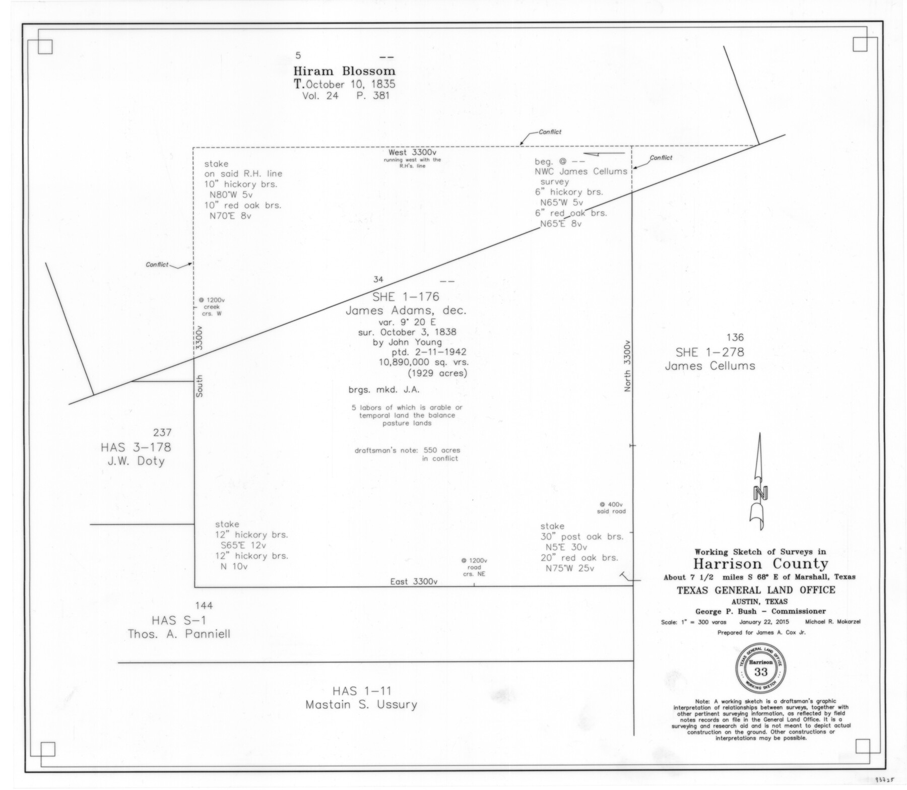
Harrison County Working Sketch 33
-
Map/Doc
93725
-
Collection
General Map Collection
-
Object Dates
1/22/2015 (Creation Date)
-
People and Organizations
Michael R. Mokarzel (Draftsman)
-
Counties
Harrison
-
Subjects
Surveying Working Sketch
-
Height x Width
19.8 x 22.8 inches
50.3 x 57.9 cm
-
Scale
1" = 300 varas
Part of: General Map Collection
Culberson County Sketch File 20

Print $57.00
- Digital $50.00
Culberson County Sketch File 20
Size 10.2 x 15.6 inches
Map/Doc 20205
Intracoastal Waterway, Houma, LA to Corpus Christi, TX

Print $4.00
- Digital $50.00
Intracoastal Waterway, Houma, LA to Corpus Christi, TX
Size 23.8 x 22.0 inches
Map/Doc 61910
Hudspeth County Rolled Sketch 55

Print $49.00
- Digital $50.00
Hudspeth County Rolled Sketch 55
1977
Size 10.0 x 15.0 inches
Map/Doc 45968
Howard County State Real Property Sketch 1

Print $40.00
- Digital $50.00
Howard County State Real Property Sketch 1
2007
Size 24.3 x 35.2 inches
Map/Doc 88673
Henderson County Rolled Sketch 11

Print $20.00
- Digital $50.00
Henderson County Rolled Sketch 11
1915
Size 29.4 x 42.4 inches
Map/Doc 75958
Stonewall County Working Sketch 7

Print $20.00
- Digital $50.00
Stonewall County Working Sketch 7
1949
Size 30.7 x 24.5 inches
Map/Doc 62314
Eastland County Working Sketch 16

Print $20.00
- Digital $50.00
Eastland County Working Sketch 16
1919
Size 19.1 x 16.7 inches
Map/Doc 68797
Flight Mission No. BQR-3K, Frame 153, Brazoria County

Print $20.00
- Digital $50.00
Flight Mission No. BQR-3K, Frame 153, Brazoria County
1952
Size 18.7 x 22.4 inches
Map/Doc 83980
Brewster County Rolled Sketch 91

Print $20.00
- Digital $50.00
Brewster County Rolled Sketch 91
1949
Size 27.5 x 15.3 inches
Map/Doc 5249
Liberty County Working Sketch 90

Print $20.00
- Digital $50.00
Liberty County Working Sketch 90
2001
Size 23.1 x 43.1 inches
Map/Doc 70550
Medina County Working Sketch 23

Print $20.00
- Digital $50.00
Medina County Working Sketch 23
Size 43.8 x 43.1 inches
Map/Doc 70938
Sketch of work done by Erath and Green in August 1846 on the north fork of Cow Bayou

Print $2.00
- Digital $50.00
Sketch of work done by Erath and Green in August 1846 on the north fork of Cow Bayou
1846
Size 9.8 x 7.9 inches
Map/Doc 78373
You may also like
Willacy County

Print $20.00
- Digital $50.00
Willacy County
1921
Size 25.2 x 32.2 inches
Map/Doc 73325
[Sketch showing C. D. & W. A. Murphy's Pasture and Wint Barfield's Pasture]
![90885, [Sketch showing C. D. & W. A. Murphy's Pasture and Wint Barfield's Pasture], Twichell Survey Records](https://historictexasmaps.com/wmedia_w700/maps/90885-1.tif.jpg)
Print $20.00
- Digital $50.00
[Sketch showing C. D. & W. A. Murphy's Pasture and Wint Barfield's Pasture]
Size 31.9 x 27.4 inches
Map/Doc 90885
Garza County Boundary File 2

Print $6.00
- Digital $50.00
Garza County Boundary File 2
Size 14.9 x 9.2 inches
Map/Doc 53673
General Highway Map. Detail of Cities and Towns in Harris County, Texas. City Map [of] Houston, Pasadena, West University Place, Bellaire, Galena Park, Jacinto City, South Houston, South Side Place, Deer Park, and vicinity, Harris County, Texas
![79504, General Highway Map. Detail of Cities and Towns in Harris County, Texas. City Map [of] Houston, Pasadena, West University Place, Bellaire, Galena Park, Jacinto City, South Houston, South Side Place, Deer Park, and vicinity, Harris County, Texas, Texas State Library and Archives](https://historictexasmaps.com/wmedia_w700/maps/79504.tif.jpg)
Print $20.00
General Highway Map. Detail of Cities and Towns in Harris County, Texas. City Map [of] Houston, Pasadena, West University Place, Bellaire, Galena Park, Jacinto City, South Houston, South Side Place, Deer Park, and vicinity, Harris County, Texas
1961
Size 18.1 x 24.8 inches
Map/Doc 79504

Montgomery County Working Sketch 16

Print $20.00
- Digital $50.00
Montgomery County Working Sketch 16
1934
Size 28.9 x 33.7 inches
Map/Doc 71123
Presidio County Rolled Sketch 37

Print $20.00
- Digital $50.00
Presidio County Rolled Sketch 37
Size 15.6 x 22.6 inches
Map/Doc 7335
Map of Mexico, including Yucatan & Upper California, exhibiting the chief cities and towns, the principal travelling routes &c.

Print $20.00
- Digital $50.00
Map of Mexico, including Yucatan & Upper California, exhibiting the chief cities and towns, the principal travelling routes &c.
1847
Size 33.5 x 24.7 inches
Map/Doc 93936
Smith County Rolled Sketch 6E1

Print $20.00
- Digital $50.00
Smith County Rolled Sketch 6E1
1966
Size 27.4 x 22.7 inches
Map/Doc 10612

Gillespie County Rolled Sketch 9

Print $20.00
- Digital $50.00
Gillespie County Rolled Sketch 9
2014
Size 23.6 x 36.2 inches
Map/Doc 93713
Montague County Working Sketch 42

Print $20.00
- Digital $50.00
Montague County Working Sketch 42
2009
Size 19.9 x 25.4 inches
Map/Doc 89004