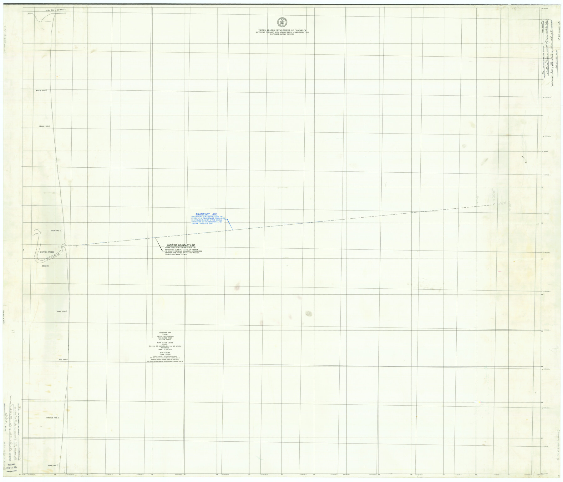
Cameron County Rolled Sketch 18
[Boundary between United States and Mexico in the Gulf of Mexico]
-
Map/Doc
8571
-
Collection
General Map Collection
-
Object Dates
1970 (Creation Date)
1974/10/7 (File Date)
-
People and Organizations
International Boundary and Water Commission (Publisher)
-
Counties
Cameron
-
Subjects
Surveying Rolled Sketch
-
Height x Width
48.9 x 57.1 inches
124.2 x 145.0 cm
-
Medium
multi-page, multi-format
-
Comments
See Cameron County Sketch File 6 (17032) for copy of report.
Related maps
Cameron County Sketch File 6

Print $20.00
- Digital $50.00
Cameron County Sketch File 6
1970
Size 11.0 x 8.5 inches
Map/Doc 17032
Part of: General Map Collection
Aransas County Rolled Sketch 10

Print $58.00
- Digital $50.00
Aransas County Rolled Sketch 10
1936
Size 10.6 x 15.4 inches
Map/Doc 42208
Stonewall County Working Sketch 1

Print $20.00
- Digital $50.00
Stonewall County Working Sketch 1
1910
Size 30.7 x 22.8 inches
Map/Doc 63995
Pecos County Sketch File 84

Print $4.00
- Digital $50.00
Pecos County Sketch File 84
1944
Size 11.2 x 8.8 inches
Map/Doc 33953
Flight Mission No. CUG-2P, Frame 12, Kleberg County

Print $20.00
- Digital $50.00
Flight Mission No. CUG-2P, Frame 12, Kleberg County
1956
Size 18.6 x 22.1 inches
Map/Doc 86184
Reagan County Working Sketch 19

Print $20.00
- Digital $50.00
Reagan County Working Sketch 19
1954
Size 24.3 x 42.9 inches
Map/Doc 71861
Map of the Central States to illustrate Olney's school geography

Print $20.00
- Digital $50.00
Map of the Central States to illustrate Olney's school geography
1844
Size 12.1 x 19.0 inches
Map/Doc 93539

Eastland County Sketch File 2b

Print $6.00
- Digital $50.00
Eastland County Sketch File 2b
1857
Size 11.1 x 8.8 inches
Map/Doc 21563
Liberty County Sketch File 5a

Print $6.00
- Digital $50.00
Liberty County Sketch File 5a
1857
Size 12.2 x 7.8 inches
Map/Doc 29887
Gregg County Sketch File 1F

Print $4.00
- Digital $50.00
Gregg County Sketch File 1F
1850
Size 12.2 x 7.8 inches
Map/Doc 24547
Galveston Entrance

Print $20.00
- Digital $50.00
Galveston Entrance
1925
Size 18.5 x 24.1 inches
Map/Doc 69859
Texas Gulf Coast Map from the Sabine River to the Rio Grande as subdivided for mineral development

Print $40.00
- Digital $50.00
Texas Gulf Coast Map from the Sabine River to the Rio Grande as subdivided for mineral development
1948
Size 48.9 x 38.0 inches
Map/Doc 2910
You may also like
Lee County Sketch File 1

Print $4.00
- Digital $50.00
Lee County Sketch File 1
1856
Size 13.1 x 8.2 inches
Map/Doc 29678
Donley County Sketch File 26

Print $6.00
- Digital $50.00
Donley County Sketch File 26
Size 12.8 x 8.3 inches
Map/Doc 21261
Travis County Sketch File 61

Print $8.00
- Digital $50.00
Travis County Sketch File 61
1948
Size 14.4 x 8.8 inches
Map/Doc 38427
Bexar County Sketch File 14

Print $4.00
- Digital $50.00
Bexar County Sketch File 14
1855
Size 7.8 x 8.2 inches
Map/Doc 14482
Marion County Working Sketch 12a

Print $20.00
- Digital $50.00
Marion County Working Sketch 12a
1953
Size 23.9 x 33.2 inches
Map/Doc 70788
United States Gulf Coast - from Galveston to the Rio Grande

Print $20.00
- Digital $50.00
United States Gulf Coast - from Galveston to the Rio Grande
1915
Size 26.4 x 18.2 inches
Map/Doc 72733
Hudspeth County Rolled Sketch 70

Print $40.00
- Digital $50.00
Hudspeth County Rolled Sketch 70
1982
Size 38.1 x 47.7 inches
Map/Doc 9233
Current Miscellaneous File 99

Print $32.00
- Digital $50.00
Current Miscellaneous File 99
1984
Size 11.2 x 8.7 inches
Map/Doc 74340
Glasscock County Sketch File 10

Print $6.00
- Digital $50.00
Glasscock County Sketch File 10
1935
Size 11.6 x 12.8 inches
Map/Doc 24172
Flight Mission No. BRA-9M, Frame 69, Jefferson County

Print $20.00
- Digital $50.00
Flight Mission No. BRA-9M, Frame 69, Jefferson County
1953
Size 18.5 x 22.3 inches
Map/Doc 85652
Franklin County Sketch File 6

Print $4.00
- Digital $50.00
Franklin County Sketch File 6
1853
Size 9.6 x 7.4 inches
Map/Doc 23018
Flight Mission No. CON-2R, Frame 94, Stonewall County

Print $20.00
- Digital $50.00
Flight Mission No. CON-2R, Frame 94, Stonewall County
1957
Size 18.5 x 22.2 inches
Map/Doc 86988