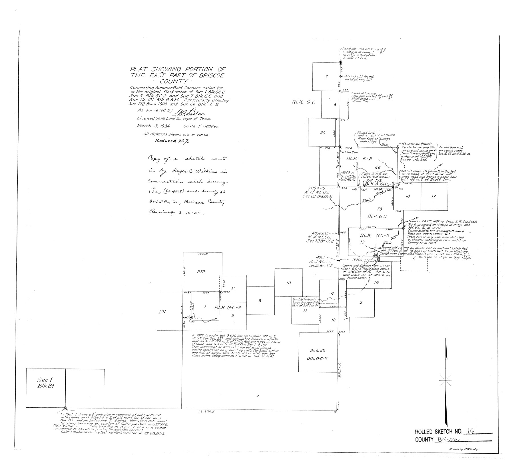
Briscoe County Rolled Sketch 16
Plat showing portion of the east part of Briscoe County connecting Summerfield corners called for in the original field notes of Sur. 1 Blk. GC-2, Sur. 5 Blk GC-2 and Sur. 7 Blk GC and Sur. No. 121 Blk. G. & M.
-
Map/Doc
5330
-
Collection
General Map Collection
-
Object Dates
1934/3/3 (Creation Date)
1934/3/10 (File Date)
-
People and Organizations
G.A. Lider (Surveyor/Engineer)
M.W. Hobbs (Draftsman)
-
Counties
Briscoe
-
Subjects
Surveying Rolled Sketch
-
Height x Width
17.8 x 19.9 inches
45.2 x 50.5 cm
-
Scale
1" = 1000 varas
Part of: General Map Collection
[Galveston, Harrisburg & San Antonio through El Paso County]
![64015, [Galveston, Harrisburg & San Antonio through El Paso County], General Map Collection](https://historictexasmaps.com/wmedia_w700/maps/64015.tif.jpg)
Print $20.00
- Digital $50.00
[Galveston, Harrisburg & San Antonio through El Paso County]
1907
Size 13.5 x 33.7 inches
Map/Doc 64015
Map of Bandera County

Print $40.00
- Digital $50.00
Map of Bandera County
1885
Size 31.6 x 63.9 inches
Map/Doc 4772
Cochran County Boundary File 7

Print $6.00
- Digital $50.00
Cochran County Boundary File 7
Size 14.0 x 9.1 inches
Map/Doc 51567
Map of Lampasas County

Print $20.00
- Digital $50.00
Map of Lampasas County
1856
Size 19.7 x 25.3 inches
Map/Doc 3792
Montgomery County Working Sketch 78

Print $20.00
- Digital $50.00
Montgomery County Working Sketch 78
2016
Size 36.3 x 24.2 inches
Map/Doc 94090
Shelby County

Print $20.00
- Digital $50.00
Shelby County
1945
Size 42.7 x 46.9 inches
Map/Doc 95639
The University of Texas at Austin

The University of Texas at Austin
Size 16.0 x 17.1 inches
Map/Doc 94388
Austin County Working Sketch 3

Print $20.00
- Digital $50.00
Austin County Working Sketch 3
1950
Size 33.3 x 40.1 inches
Map/Doc 67244
Le Nouveau Mexique et la Floride: Tirèes de diverses cartes, et relations

Print $20.00
- Digital $50.00
Le Nouveau Mexique et la Floride: Tirèes de diverses cartes, et relations
1656
Size 17.2 x 22.8 inches
Map/Doc 95833
El Paso County Sketch File 22a

Print $52.00
- Digital $50.00
El Paso County Sketch File 22a
1888
Size 14.2 x 8.7 inches
Map/Doc 22042
Karnes County Sketch File 6

Print $4.00
- Digital $50.00
Karnes County Sketch File 6
1858
Size 7.7 x 8.1 inches
Map/Doc 28557
Zavala County Sketch File 21

Print $4.00
- Digital $50.00
Zavala County Sketch File 21
1915
Size 11.5 x 8.8 inches
Map/Doc 41376
You may also like
Cass County Working Sketch 18

Print $20.00
- Digital $50.00
Cass County Working Sketch 18
1958
Size 24.2 x 44.3 inches
Map/Doc 67921
Sketch from Oldham County

Print $20.00
- Digital $50.00
Sketch from Oldham County
1901
Size 23.5 x 20.9 inches
Map/Doc 91404
Somervell County

Print $20.00
- Digital $50.00
Somervell County
1941
Size 28.1 x 26.1 inches
Map/Doc 73291
Sketch E Showing the Progress of the Survey of Section V From 1847 to 1852

Print $20.00
- Digital $50.00
Sketch E Showing the Progress of the Survey of Section V From 1847 to 1852
1852
Size 12.4 x 22.7 inches
Map/Doc 97213
Pecos County Rolled Sketch 143

Print $74.00
- Digital $50.00
Pecos County Rolled Sketch 143
1935
Size 14.8 x 9.4 inches
Map/Doc 48359
Parker County Working Sketch 6

Print $20.00
- Digital $50.00
Parker County Working Sketch 6
1923
Map/Doc 71456
Calhoun County Working Sketch Graphic Index

Print $40.00
- Digital $50.00
Calhoun County Working Sketch Graphic Index
1948
Size 48.2 x 40.1 inches
Map/Doc 76484
Matagorda Bay and Approaches

Print $20.00
- Digital $50.00
Matagorda Bay and Approaches
1974
Size 35.1 x 44.6 inches
Map/Doc 73386
Eastland County Rolled Sketch 26

Print $20.00
- Digital $50.00
Eastland County Rolled Sketch 26
1918
Size 23.2 x 17.9 inches
Map/Doc 5777
Montague County Boundary File 1

Print $32.00
- Digital $50.00
Montague County Boundary File 1
Size 12.8 x 8.1 inches
Map/Doc 57399
Shelby County Working Sketch 27

Print $20.00
- Digital $50.00
Shelby County Working Sketch 27
1995
Size 32.8 x 39.9 inches
Map/Doc 63881
Dimmit County Sketch File 19 1/2

Print $40.00
- Digital $50.00
Dimmit County Sketch File 19 1/2
Size 16.6 x 13.9 inches
Map/Doc 21092