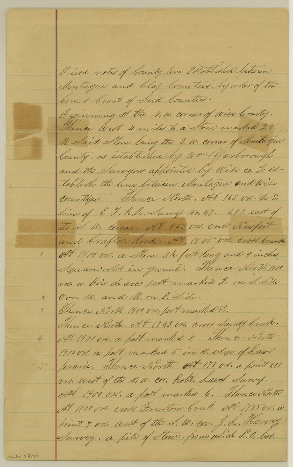
Montague County Boundary File 1
Clay & Montague
-
Map/Doc
57399
-
Collection
General Map Collection
-
Counties
Montague
-
Subjects
County Boundaries
-
Height x Width
12.8 x 8.1 inches
32.5 x 20.6 cm
Part of: General Map Collection
Harris County Sketch File 20a

Print $4.00
- Digital $50.00
Harris County Sketch File 20a
Size 8.8 x 14.4 inches
Map/Doc 25371
Sherman County Boundary File Index

Print $2.00
- Digital $50.00
Sherman County Boundary File Index
Size 8.8 x 13.2 inches
Map/Doc 58750
Uvalde County Working Sketch 15

Print $20.00
- Digital $50.00
Uvalde County Working Sketch 15
1945
Size 18.5 x 26.9 inches
Map/Doc 72085
Crockett County Working Sketch 24

Print $20.00
- Digital $50.00
Crockett County Working Sketch 24
1920
Size 43.0 x 17.7 inches
Map/Doc 68357
Flight Mission No. BRE-5P, Frame 199, Nueces County

Print $20.00
- Digital $50.00
Flight Mission No. BRE-5P, Frame 199, Nueces County
1956
Size 18.4 x 22.3 inches
Map/Doc 86839
Concho County Sketch File 30

Print $20.00
- Digital $50.00
Concho County Sketch File 30
1858
Size 13.8 x 20.4 inches
Map/Doc 11156
Morris County Rolled Sketch 2A

Print $20.00
- Digital $50.00
Morris County Rolled Sketch 2A
Size 24.2 x 19.0 inches
Map/Doc 10253
Pecos County Rolled Sketch 79

Print $20.00
- Digital $50.00
Pecos County Rolled Sketch 79
1930
Size 28.5 x 32.6 inches
Map/Doc 7239

Webb County Rolled Sketch 9

Print $20.00
- Digital $50.00
Webb County Rolled Sketch 9
1905
Size 12.6 x 16.3 inches
Map/Doc 8175
Flight Mission No. BRA-8M, Frame 68, Jefferson County

Print $20.00
- Digital $50.00
Flight Mission No. BRA-8M, Frame 68, Jefferson County
1953
Size 18.6 x 22.4 inches
Map/Doc 85588
Polk County Sketch File 36

Print $46.00
- Digital $50.00
Polk County Sketch File 36
1908
Size 13.8 x 8.6 inches
Map/Doc 34236
You may also like
[West Half of Potter County, South of River and West Half of Randall County]
![91828, [West Half of Potter County, South of River and West Half of Randall County], Twichell Survey Records](https://historictexasmaps.com/wmedia_w700/maps/91828.tif.jpg)
Print $20.00
- Digital $50.00
[West Half of Potter County, South of River and West Half of Randall County]
Size 25.9 x 43.0 inches
Map/Doc 91828
Scurry County Working Sketch 5

Print $40.00
- Digital $50.00
Scurry County Working Sketch 5
1950
Size 72.5 x 27.8 inches
Map/Doc 63834
[Resurvey of the north half of Block M6]
![90400, [Resurvey of the north half of Block M6], Twichell Survey Records](https://historictexasmaps.com/wmedia_w700/maps/90400-1.tif.jpg)
Print $20.00
- Digital $50.00
[Resurvey of the north half of Block M6]
Size 19.0 x 21.1 inches
Map/Doc 90400
Jones County Sketch File 8

Print $20.00
- Digital $50.00
Jones County Sketch File 8
Size 18.5 x 22.8 inches
Map/Doc 11898
Kerr County Rolled Sketch 11A

Print $20.00
- Digital $50.00
Kerr County Rolled Sketch 11A
1950
Size 27.8 x 36.0 inches
Map/Doc 6496
Leon County Working Sketch 59

Print $20.00
- Digital $50.00
Leon County Working Sketch 59
1998
Size 19.2 x 25.5 inches
Map/Doc 70459
[Surveys in Tyler County]
![352, [Surveys in Tyler County], General Map Collection](https://historictexasmaps.com/wmedia_w700/maps/352.tif.jpg)
Print $2.00
- Digital $50.00
[Surveys in Tyler County]
1847
Size 8.3 x 5.2 inches
Map/Doc 352
[Blks. Z, C4, 194, 178, C3, A2, 179 and 207]
![89837, [Blks. Z, C4, 194, 178, C3, A2, 179 and 207], Twichell Survey Records](https://historictexasmaps.com/wmedia_w700/maps/89837-1.tif.jpg)
Print $40.00
- Digital $50.00
[Blks. Z, C4, 194, 178, C3, A2, 179 and 207]
Size 61.6 x 37.5 inches
Map/Doc 89837
Flight Mission No. BRE-1P, Frame 27, Nueces County

Print $20.00
- Digital $50.00
Flight Mission No. BRE-1P, Frame 27, Nueces County
1956
Size 18.5 x 22.4 inches
Map/Doc 86622
Flight Mission No. DIX-7P, Frame 21, Aransas County

Print $20.00
- Digital $50.00
Flight Mission No. DIX-7P, Frame 21, Aransas County
1956
Size 18.8 x 22.6 inches
Map/Doc 83873
Flight Mission No. CRC-2R, Frame 112, Chambers County

Print $20.00
- Digital $50.00
Flight Mission No. CRC-2R, Frame 112, Chambers County
1956
Size 18.5 x 22.3 inches
Map/Doc 84739
Swisher County Sketch File 11

Print $58.00
- Digital $50.00
Swisher County Sketch File 11
1917
Size 9.1 x 8.3 inches
Map/Doc 37633