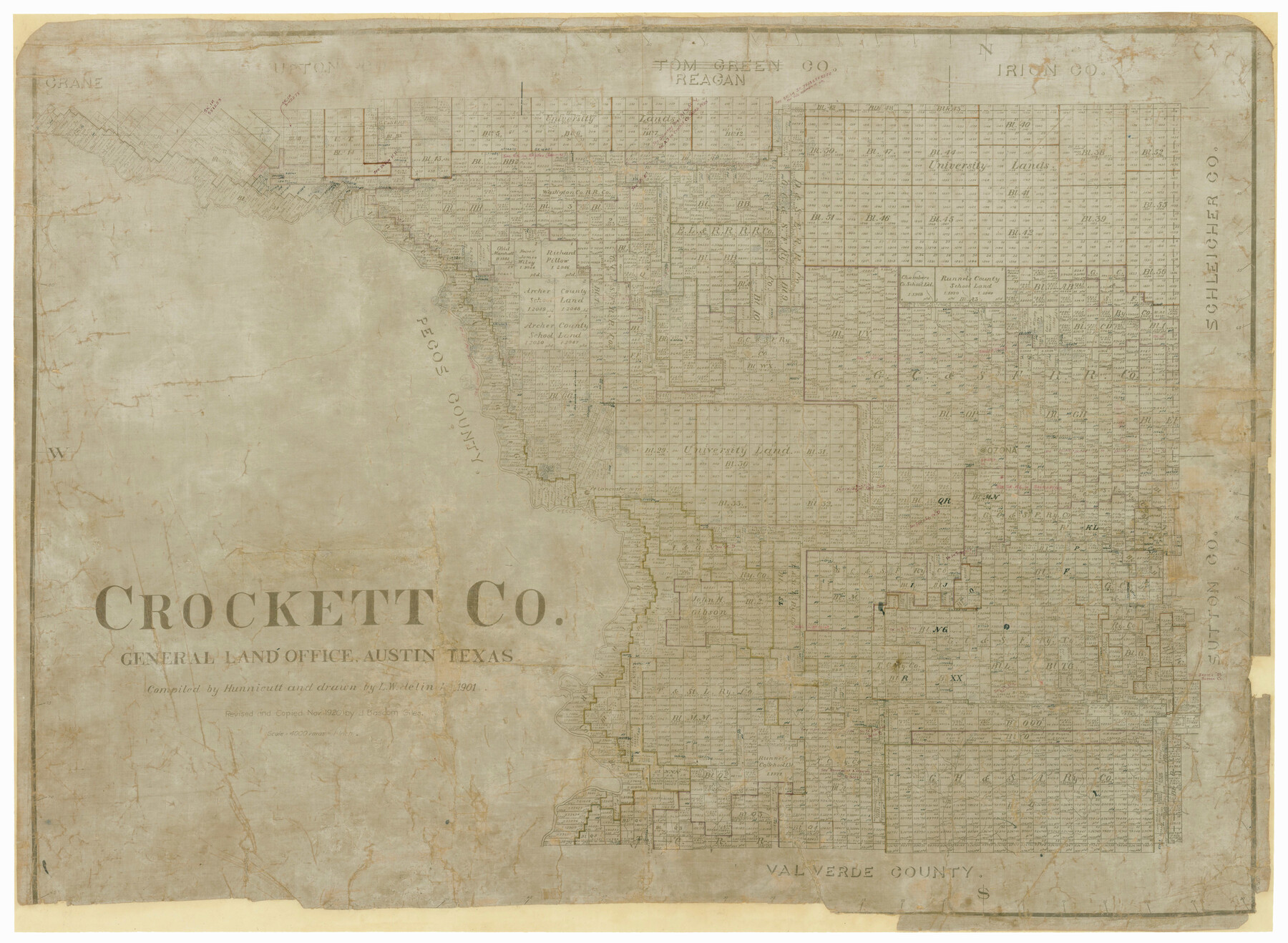
Crockett Co.
-
Map/Doc
4727
-
Collection
General Map Collection
-
Object Dates
1901 (Creation Date)
-
People and Organizations
Texas General Land Office (Publisher)
Hunnicutt (Compiler)
L.W. Jelinek (Draftsman)
-
Counties
Crockett
-
Subjects
County
-
Height x Width
32.3 x 44.9 inches
82.0 x 114.0 cm
-
Comments
Revised and copied in November 1920 by J. Bascom Giles.
Copy No. 2.
Help Save Texas History - Adopt Me! -
Features
Pontoon Bridge
Pecos River
Johnsons Run Creek
Ozona
Fort Lancaster
Part of: General Map Collection
Limestone County Working Sketch 24

Print $20.00
- Digital $50.00
Limestone County Working Sketch 24
1980
Size 28.9 x 31.6 inches
Map/Doc 70574
Flight Mission No. BRA-3M, Frame 191, Jefferson County

Print $20.00
- Digital $50.00
Flight Mission No. BRA-3M, Frame 191, Jefferson County
1953
Size 18.6 x 22.3 inches
Map/Doc 85406
Map of Briscoe County

Print $20.00
- Digital $50.00
Map of Briscoe County
1901
Size 41.4 x 38.0 inches
Map/Doc 4893
Flight Mission No. BRA-16M, Frame 55, Jefferson County

Print $20.00
- Digital $50.00
Flight Mission No. BRA-16M, Frame 55, Jefferson County
1953
Size 18.4 x 22.4 inches
Map/Doc 85672
Comanche County Working Sketch 28

Print $20.00
- Digital $50.00
Comanche County Working Sketch 28
1984
Size 22.9 x 25.7 inches
Map/Doc 68162
Travis County Boundary File 30

Print $4.00
- Digital $50.00
Travis County Boundary File 30
Size 10.4 x 8.6 inches
Map/Doc 59469
El Paso County Rolled Sketch 52

Print $20.00
- Digital $50.00
El Paso County Rolled Sketch 52
1929
Size 18.6 x 24.5 inches
Map/Doc 5846
Johnson County Sketch File 15

Print $2.00
- Digital $50.00
Johnson County Sketch File 15
1881
Size 8.1 x 7.3 inches
Map/Doc 28455
Stephens County Boundary File 6

Print $12.00
- Digital $50.00
Stephens County Boundary File 6
Size 13.0 x 8.5 inches
Map/Doc 58901
Flight Mission No. DAG-21K, Frame 91, Matagorda County

Print $20.00
- Digital $50.00
Flight Mission No. DAG-21K, Frame 91, Matagorda County
1952
Size 18.5 x 22.4 inches
Map/Doc 86420
Pecos County Working Sketch 71

Print $20.00
- Digital $50.00
Pecos County Working Sketch 71
1957
Size 41.6 x 26.0 inches
Map/Doc 71543
The Absolem C. De La Plain League and Labor of Land

Print $20.00
- Digital $50.00
The Absolem C. De La Plain League and Labor of Land
2013
Size 30.0 x 24.0 inches
Map/Doc 93425
You may also like
[Sections 5 through 34]
![92480, [Sections 5 through 34], Twichell Survey Records](https://historictexasmaps.com/wmedia_w700/maps/92480-1.tif.jpg)
Print $20.00
- Digital $50.00
[Sections 5 through 34]
Size 23.9 x 19.4 inches
Map/Doc 92480
Map of Espiritu Santo Bay in Calhoun County showing subdivision therof for mineral development

Print $20.00
- Digital $50.00
Map of Espiritu Santo Bay in Calhoun County showing subdivision therof for mineral development
1938
Size 38.6 x 42.9 inches
Map/Doc 2499
Culberson County Working Sketch 27

Print $40.00
- Digital $50.00
Culberson County Working Sketch 27
1952
Size 22.2 x 53.4 inches
Map/Doc 68480
Travis County Rolled Sketch 5

Print $20.00
- Digital $50.00
Travis County Rolled Sketch 5
1924
Size 24.1 x 27.9 inches
Map/Doc 8011
Map of Harris County

Print $40.00
- Digital $50.00
Map of Harris County
1897
Size 48.4 x 68.5 inches
Map/Doc 82069
Maps of Gulf Intracoastal Waterway, Texas - Sabine River to the Rio Grande and connecting waterways including ship channels

Print $20.00
- Digital $50.00
Maps of Gulf Intracoastal Waterway, Texas - Sabine River to the Rio Grande and connecting waterways including ship channels
1966
Size 14.5 x 22.4 inches
Map/Doc 61951
Grayson County Rolled Sketch 3

Print $20.00
- Digital $50.00
Grayson County Rolled Sketch 3
1952
Size 33.7 x 46.1 inches
Map/Doc 9666
Crockett County Working Sketch 96

Print $20.00
- Digital $50.00
Crockett County Working Sketch 96
1979
Size 25.5 x 16.9 inches
Map/Doc 68429
Dickens County Working Sketch 15

Print $20.00
- Digital $50.00
Dickens County Working Sketch 15
2011
Size 28.8 x 28.6 inches
Map/Doc 90067
Topographic Map of Texas and Oklahoma Boundary, Fort Augur Area

Print $20.00
Topographic Map of Texas and Oklahoma Boundary, Fort Augur Area
1924
Size 32.3 x 33.8 inches
Map/Doc 79755
Flight Mission No. DAH-17M, Frame 67, Orange County

Print $20.00
- Digital $50.00
Flight Mission No. DAH-17M, Frame 67, Orange County
1953
Size 18.5 x 22.3 inches
Map/Doc 86901
Harris County

Print $40.00
- Digital $50.00
Harris County
1896
Size 44.4 x 69.3 inches
Map/Doc 66857