Polk County Sketch File 36
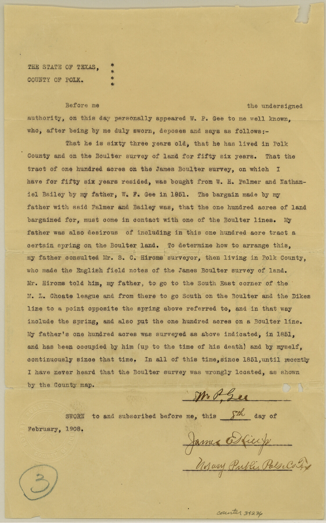
[Report and statements regarding the James Boulter and J. M. Dikes surveys]
-
Map/Doc
34236
-
Collection
General Map Collection
-
Object Dates
2/8/1908 (Creation Date)
4/13/1909 (File Date)
12/3/1907 (Creation Date)
6/17/1907 (Correspondence Date)
-
People and Organizations
W.H. Hill (Surveyor/Engineer)
B.J. Wilcoxon (Surveyor/Engineer)
C.A. Noblitt (Surveyor/Engineer)
A.B. Garvey (Surveyor/Engineer)
S.C. Hirams (Surveyor/Engineer)
H. Jackson (Surveyor/Engineer)
John E. Baumgarthen (Surveyor/Engineer)
W.H. Matthews (Surveyor/Engineer)
Wilcoxon (Surveyor/Engineer)
M.L. Choate (Chainman/Field Personnel)
D. McPherson (Chainman/Field Personnel)
I. White (Chainman/Field Personnel)
John R. Johnson (Surveyor/Engineer)
W.F. Gee (Surveyor/Engineer)
-
Counties
Polk
-
Subjects
Surveying Sketch File
-
Height x Width
13.8 x 8.6 inches
35.1 x 21.8 cm
-
Medium
multi-page, multi-format
-
Features
Long King Creek
Tempe Creek
Livingston and Liberty Road
Choates Creek
Part of: General Map Collection
Maverick County Sketch File 13

Print $14.00
- Digital $50.00
Maverick County Sketch File 13
1882
Size 12.7 x 8.0 inches
Map/Doc 31102
Flight Mission No. BRA-16M, Frame 101, Jefferson County

Print $20.00
- Digital $50.00
Flight Mission No. BRA-16M, Frame 101, Jefferson County
1953
Size 18.6 x 22.4 inches
Map/Doc 85713
Milam County Working Sketch 10

Print $20.00
- Digital $50.00
Milam County Working Sketch 10
1986
Size 25.5 x 34.6 inches
Map/Doc 71025
Hudspeth County Working Sketch 48

Print $20.00
- Digital $50.00
Hudspeth County Working Sketch 48
1984
Size 36.6 x 46.3 inches
Map/Doc 66333
Index for Texas Railroad ROW & track maps available on microfilm at THD & Archives and Records

Print $2.00
- Digital $50.00
Index for Texas Railroad ROW & track maps available on microfilm at THD & Archives and Records
1977
Size 11.1 x 8.9 inches
Map/Doc 60755
Newton County Boundary File 1

Print $4.00
- Digital $50.00
Newton County Boundary File 1
Size 14.3 x 8.8 inches
Map/Doc 57614
Hutchinson County Sketch File 42

Print $9.00
- Digital $50.00
Hutchinson County Sketch File 42
1920
Size 14.3 x 8.9 inches
Map/Doc 27305
Fort Bend County Rolled Sketch 7

Print $20.00
- Digital $50.00
Fort Bend County Rolled Sketch 7
1919
Size 21.1 x 24.0 inches
Map/Doc 5898
United States and Additions, 1820

Print $20.00
- Digital $50.00
United States and Additions, 1820
1820
Size 21.8 x 27.0 inches
Map/Doc 93798
Rusk County Sketch File 27a

Print $10.00
Rusk County Sketch File 27a
1936
Size 14.2 x 8.8 inches
Map/Doc 35532
Dimmit County Sketch File 21

Print $16.00
- Digital $50.00
Dimmit County Sketch File 21
1898
Size 14.4 x 8.8 inches
Map/Doc 21115
Flight Mission No. DAG-17K, Frame 125, Matagorda County

Print $20.00
- Digital $50.00
Flight Mission No. DAG-17K, Frame 125, Matagorda County
1952
Size 18.6 x 22.4 inches
Map/Doc 86345
You may also like
Travis County Rolled Sketch 44

Print $20.00
- Digital $50.00
Travis County Rolled Sketch 44
Size 34.2 x 35.6 inches
Map/Doc 10052
Medina County Boundary File 1

Print $14.00
- Digital $50.00
Medina County Boundary File 1
Size 12.8 x 8.1 inches
Map/Doc 57019
J. De Cordova's Map of the State of Texas Compiled from the records of the General Land Office of the State

Print $20.00
- Digital $50.00
J. De Cordova's Map of the State of Texas Compiled from the records of the General Land Office of the State
1849
Size 33.9 x 32.1 inches
Map/Doc 7826
Flight Mission No. CRC-2R, Frame 192, Chambers County

Print $20.00
- Digital $50.00
Flight Mission No. CRC-2R, Frame 192, Chambers County
1956
Size 18.6 x 22.3 inches
Map/Doc 84770
Shelby County Working Sketch 28

Print $20.00
- Digital $50.00
Shelby County Working Sketch 28
2000
Size 28.8 x 29.8 inches
Map/Doc 63882
Kerr County Working Sketch 12

Print $20.00
- Digital $50.00
Kerr County Working Sketch 12
1951
Size 34.3 x 37.0 inches
Map/Doc 70043
Coast Chart No. 211 - Padre I. and Laguna Madre Lat. 27° 12' to Lat. 26° 33' Texas

Print $20.00
- Digital $50.00
Coast Chart No. 211 - Padre I. and Laguna Madre Lat. 27° 12' to Lat. 26° 33' Texas
1890
Size 27.5 x 18.2 inches
Map/Doc 72822
Aransas County Rolled Sketch 34

Print $42.00
- Digital $50.00
Aransas County Rolled Sketch 34
2004
Size 24.5 x 36.5 inches
Map/Doc 83637
Lynn County Boundary File 9

Print $24.00
- Digital $50.00
Lynn County Boundary File 9
Size 11.3 x 8.8 inches
Map/Doc 56657
Angelina County Working Sketch 6

Print $20.00
- Digital $50.00
Angelina County Working Sketch 6
1914
Size 17.5 x 15.1 inches
Map/Doc 67087
Hardin County Rolled Sketch 23

Print $20.00
- Digital $50.00
Hardin County Rolled Sketch 23
1982
Size 28.5 x 45.2 inches
Map/Doc 6091
