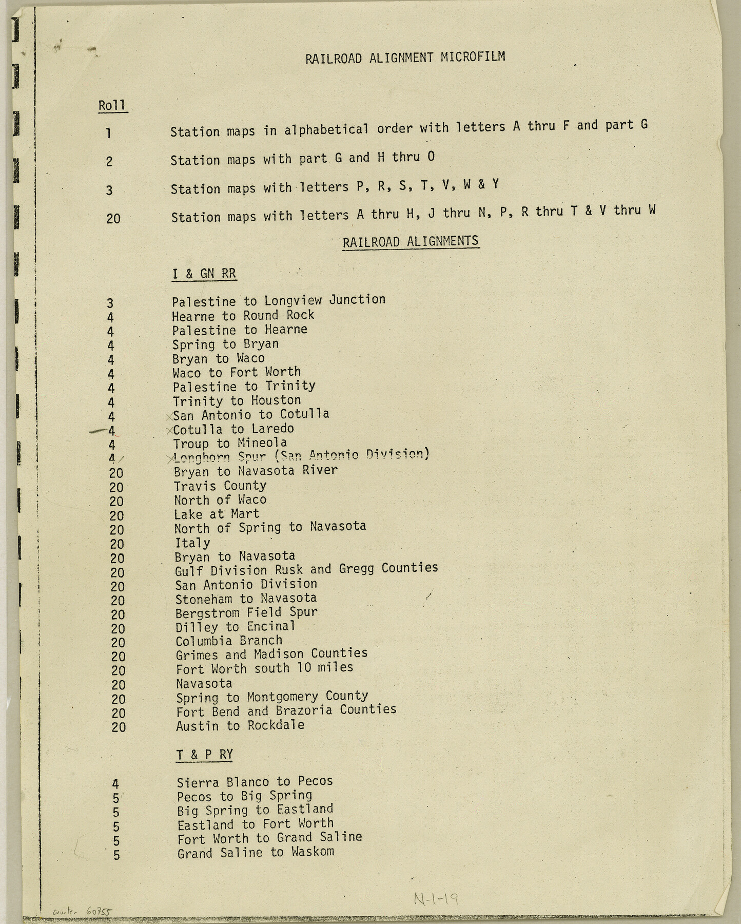
Index for Texas Railroad ROW & track maps available on microfilm at THD & Archives and Records
N-1-19
-
Map/Doc
60755
-
Collection
General Map Collection
-
Object Dates
1977 (Creation Date)
-
Height x Width
11.1 x 8.9 inches
28.2 x 22.6 cm
Part of: General Map Collection
[Sketch & Field Note Calls of Pecos, Terrell & Val Verde Counties, Texas]
![1720, [Sketch & Field Note Calls of Pecos, Terrell & Val Verde Counties, Texas], General Map Collection](https://historictexasmaps.com/wmedia_w700/pdf_converted_jpg/qi_pdf_thumbnail_734.jpg)
Print $20.00
- Digital $50.00
[Sketch & Field Note Calls of Pecos, Terrell & Val Verde Counties, Texas]
1915
Size 19.4 x 24.2 inches
Map/Doc 1720
Flight Mission No. CGI-1N, Frame 134, Cameron County

Print $20.00
- Digital $50.00
Flight Mission No. CGI-1N, Frame 134, Cameron County
1955
Size 18.5 x 22.1 inches
Map/Doc 84490
Aransas County Working Sketch Graphic Index

Print $20.00
- Digital $50.00
Aransas County Working Sketch Graphic Index
1947
Size 36.8 x 36.6 inches
Map/Doc 76455
Chart of Yellow Fever in the United States

Print $20.00
- Digital $50.00
Chart of Yellow Fever in the United States
1874
Size 16.3 x 17.2 inches
Map/Doc 95701
Upshur County Sketch File 22

Print $8.00
- Digital $50.00
Upshur County Sketch File 22
2015
Size 11.0 x 8.5 inches
Map/Doc 93774
Reeves County Working Sketch 45

Print $20.00
- Digital $50.00
Reeves County Working Sketch 45
1974
Size 46.9 x 32.3 inches
Map/Doc 63488
Cochran County Rolled Sketch RM

Print $40.00
- Digital $50.00
Cochran County Rolled Sketch RM
1938
Size 29.4 x 107.6 inches
Map/Doc 8605
Glasscock County Working Sketch 16

Print $40.00
- Digital $50.00
Glasscock County Working Sketch 16
1984
Size 61.2 x 44.0 inches
Map/Doc 63189
Uvalde County Working Sketch 37

Print $20.00
- Digital $50.00
Uvalde County Working Sketch 37
1969
Size 26.7 x 34.0 inches
Map/Doc 72107
Comal County Working Sketch 12

Print $20.00
- Digital $50.00
Comal County Working Sketch 12
1987
Size 31.1 x 29.6 inches
Map/Doc 68178
Upton County Sketch File 35

Print $14.00
- Digital $50.00
Upton County Sketch File 35
1942
Size 11.4 x 8.8 inches
Map/Doc 38886

You may also like
Flight Mission No. CGI-1N, Frame 174, Cameron County

Print $20.00
- Digital $50.00
Flight Mission No. CGI-1N, Frame 174, Cameron County
1955
Size 18.5 x 22.1 inches
Map/Doc 84509
[Garza, Blanco, Uvalde and Crosby County School Land]
![90252, [Garza, Blanco, Uvalde and Crosby County School Land], Twichell Survey Records](https://historictexasmaps.com/wmedia_w700/maps/90252-1.tif.jpg)
Print $20.00
- Digital $50.00
[Garza, Blanco, Uvalde and Crosby County School Land]
1913
Size 12.4 x 12.2 inches
Map/Doc 90252
Working Sketch in Eastland County

Print $20.00
- Digital $50.00
Working Sketch in Eastland County
1919
Size 20.1 x 14.6 inches
Map/Doc 90931
[Block B and surrounding areas]
![90331, [Block B and surrounding areas], Twichell Survey Records](https://historictexasmaps.com/wmedia_w700/maps/90331-1.tif.jpg)
Print $20.00
- Digital $50.00
[Block B and surrounding areas]
Size 20.3 x 20.3 inches
Map/Doc 90331
Flight Mission No. DQN-2K, Frame 157, Calhoun County

Print $20.00
- Digital $50.00
Flight Mission No. DQN-2K, Frame 157, Calhoun County
1953
Size 18.5 x 22.2 inches
Map/Doc 84319
Flight Mission No. DQO-7K, Frame 111, Galveston County

Print $20.00
- Digital $50.00
Flight Mission No. DQO-7K, Frame 111, Galveston County
1952
Size 18.7 x 22.4 inches
Map/Doc 85126
Flight Mission No. CRC-2R, Frame 180, Chambers County

Print $20.00
- Digital $50.00
Flight Mission No. CRC-2R, Frame 180, Chambers County
1956
Size 18.7 x 22.4 inches
Map/Doc 84758
Val Verde County Sketch File 38

Print $44.00
- Digital $50.00
Val Verde County Sketch File 38
1938
Size 17.6 x 17.2 inches
Map/Doc 12579
Callahan County Sketch File 7

Print $18.00
- Digital $50.00
Callahan County Sketch File 7
Size 10.8 x 8.9 inches
Map/Doc 35863
Runnels County Rolled Sketch 32

Print $20.00
- Digital $50.00
Runnels County Rolled Sketch 32
Size 34.9 x 44.5 inches
Map/Doc 9868
Brewster County Rolled Sketch 82

Print $20.00
- Digital $50.00
Brewster County Rolled Sketch 82
1945
Size 20.3 x 23.3 inches
Map/Doc 5245
Map of San Gabriel & Lampassas [sic] Surveys
![58, Map of San Gabriel & Lampassas [sic] Surveys, General Map Collection](https://historictexasmaps.com/wmedia_w700/maps/58.tif.jpg)
Print $20.00
- Digital $50.00
Map of San Gabriel & Lampassas [sic] Surveys
1841
Size 29.0 x 20.0 inches
Map/Doc 58