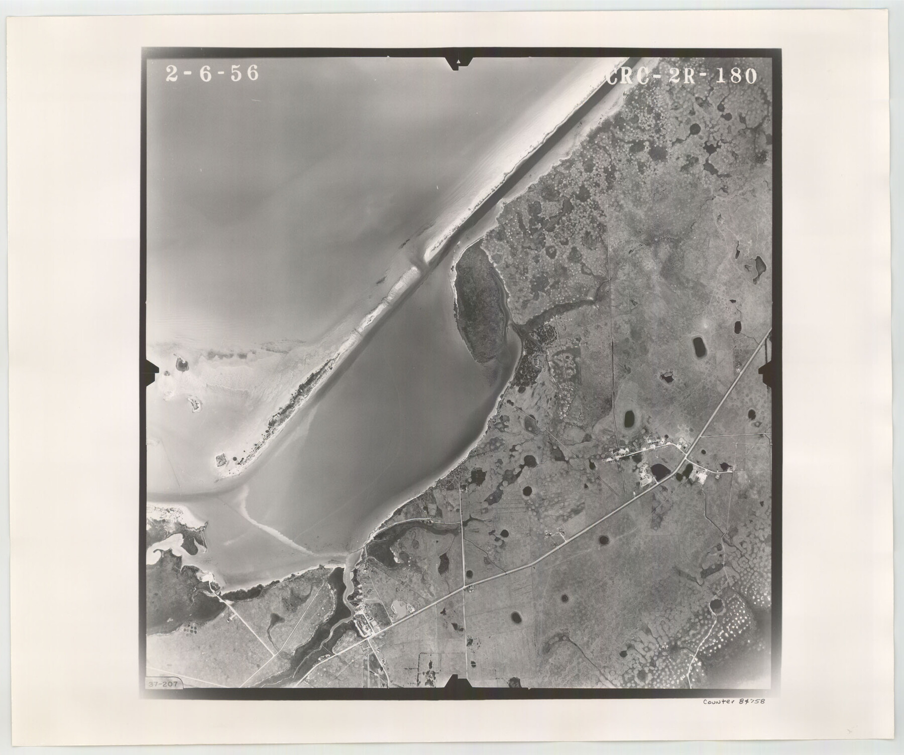
Flight Mission No. CRC-2R, Frame 180, Chambers County
CRC-2R-180
-
Map/Doc
84758
-
Collection
General Map Collection
-
Object Dates
1956/2/6 (Creation Date)
-
People and Organizations
U. S. Department of Agriculture (Publisher)
-
Counties
Chambers
-
Subjects
Aerial Photograph
-
Height x Width
18.7 x 22.4 inches
47.5 x 56.9 cm
-
Comments
Flown by Jack Ammann Photogrammetric Engineers, Inc. of San Antonio, Texas.
Part of: General Map Collection
Township No. 5 South Range No. 15 West, Indian Meridian, Oklahoma

Print $4.00
- Digital $50.00
Township No. 5 South Range No. 15 West, Indian Meridian, Oklahoma
1927
Size 18.2 x 23.9 inches
Map/Doc 75136
Lamar County Sketch File 12

Print $20.00
- Digital $50.00
Lamar County Sketch File 12
Size 19.5 x 23.3 inches
Map/Doc 11967
Gonzales County

Print $40.00
- Digital $50.00
Gonzales County
1920
Size 48.4 x 44.2 inches
Map/Doc 4706
[Surveys in Liberty County]
![69750, [Surveys in Liberty County], General Map Collection](https://historictexasmaps.com/wmedia_w700/maps/69750.tif.jpg)
Print $2.00
- Digital $50.00
[Surveys in Liberty County]
Size 5.8 x 9.3 inches
Map/Doc 69750
Reeves County Working Sketch 2

Print $20.00
- Digital $50.00
Reeves County Working Sketch 2
1903
Size 22.6 x 42.4 inches
Map/Doc 63444
Map of Crockett County

Print $40.00
- Digital $50.00
Map of Crockett County
1878
Size 62.5 x 51.1 inches
Map/Doc 93372
Map of Chicago, Rock Island & Texas Railway

Print $20.00
- Digital $50.00
Map of Chicago, Rock Island & Texas Railway
1892
Size 22.4 x 44.0 inches
Map/Doc 64443
Old Miscellaneous File 19

Print $32.00
- Digital $50.00
Old Miscellaneous File 19
Size 14.2 x 8.8 inches
Map/Doc 75499
Anderson County Sketch File 7

Print $4.00
- Digital $50.00
Anderson County Sketch File 7
Size 7.9 x 10.0 inches
Map/Doc 12757
Flight Mission No. CLL-1N, Frame 79, Willacy County

Print $20.00
- Digital $50.00
Flight Mission No. CLL-1N, Frame 79, Willacy County
1954
Size 18.6 x 22.2 inches
Map/Doc 87025
Flight Mission No. DQN-2K, Frame 46, Calhoun County

Print $20.00
- Digital $50.00
Flight Mission No. DQN-2K, Frame 46, Calhoun County
1953
Size 18.5 x 22.1 inches
Map/Doc 84251
Glasscock County Sketch File 25

Print $20.00
- Digital $50.00
Glasscock County Sketch File 25
1951
Size 28.8 x 20.6 inches
Map/Doc 11566
You may also like
Flight Mission No. DCL-7C, Frame 110, Kenedy County

Print $20.00
- Digital $50.00
Flight Mission No. DCL-7C, Frame 110, Kenedy County
1943
Size 18.5 x 22.3 inches
Map/Doc 86075
Live Oak County Sketch File 22

Print $20.00
- Digital $50.00
Live Oak County Sketch File 22
Size 17.4 x 9.7 inches
Map/Doc 30299
El Paso County Rolled Sketch 52

Print $20.00
- Digital $50.00
El Paso County Rolled Sketch 52
1932
Size 18.3 x 24.3 inches
Map/Doc 5843
General Highway Map, Carson County, Texas

Print $20.00
General Highway Map, Carson County, Texas
1940
Size 18.5 x 25.1 inches
Map/Doc 79041
Harbor Pass and Bar at Brazos Santiago, Texas

Print $20.00
- Digital $50.00
Harbor Pass and Bar at Brazos Santiago, Texas
1871
Size 26.8 x 18.3 inches
Map/Doc 72984
[Elizabeth Stanley, William H. Anderson, and surrounding surveys]
![91022, [Elizabeth Stanley, William H. Anderson, and surrounding surveys], Twichell Survey Records](https://historictexasmaps.com/wmedia_w700/maps/91022-1.tif.jpg)
Print $20.00
- Digital $50.00
[Elizabeth Stanley, William H. Anderson, and surrounding surveys]
Size 27.0 x 18.9 inches
Map/Doc 91022
[Missouri, Kansas & Texas Line Map through Bastrop County]
![64031, [Missouri, Kansas & Texas Line Map through Bastrop County], General Map Collection](https://historictexasmaps.com/wmedia_w700/maps/64031.tif.jpg)
Print $40.00
- Digital $50.00
[Missouri, Kansas & Texas Line Map through Bastrop County]
1916
Size 26.5 x 124.4 inches
Map/Doc 64031
Polk County Working Sketch 24

Print $20.00
- Digital $50.00
Polk County Working Sketch 24
1957
Size 24.8 x 25.3 inches
Map/Doc 71640
Webb County Rolled Sketch 5

Print $20.00
- Digital $50.00
Webb County Rolled Sketch 5
Size 43.2 x 23.0 inches
Map/Doc 8172
Harris County Working Sketch 27

Print $20.00
- Digital $50.00
Harris County Working Sketch 27
1933
Size 36.9 x 43.0 inches
Map/Doc 65919
Flight Mission No. CGI-4N, Frame 164, Cameron County

Print $20.00
- Digital $50.00
Flight Mission No. CGI-4N, Frame 164, Cameron County
1955
Size 18.6 x 22.3 inches
Map/Doc 84672
Shelby County Sketch File 19

Print $22.00
- Digital $50.00
Shelby County Sketch File 19
Size 12.4 x 12.6 inches
Map/Doc 36638