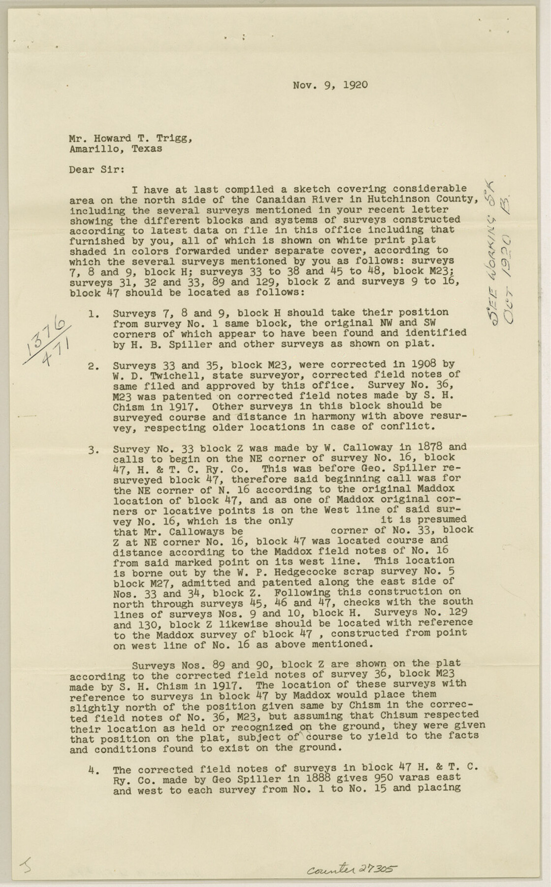
Hutchinson County Sketch File 42
[Letters to and from Howard T. Trigg relative to H. & T. C. RR. Co. Block 47, Block Z and adjoining surveys]
-
Map/Doc
27305
-
Collection
General Map Collection
-
Object Dates
6/12/1956 (File Date)
11/9/1920 (Correspondence Date)
1908 (Survey Date)
1917 (Survey Date)
6/28/1921 (Correspondence Date)
10/1920 (Creation Date)
1/15/1920 (Creation Date)
7/1890 (Survey Date)
12/22/1902 (File Date)
-
People and Organizations
H.B. Spiller (Surveyor/Engineer)
W.D. Twichell (Surveyor/Engineer)
George Spiller (Surveyor/Engineer)
Francis M. Maddox (Surveyor/Engineer)
S.H. Chism (Surveyor/Engineer)
-
Counties
Hutchinson
-
Subjects
Surveying Sketch File
-
Height x Width
14.3 x 8.9 inches
36.3 x 22.6 cm
-
Medium
paper, print
-
Comments
See Working Sketch Hutchinson County (89709) for sketch.
-
Features
Canadian River
Related maps
Hutchinson County Working Sketch 9

Print $20.00
- Digital $50.00
Hutchinson County Working Sketch 9
1920
Size 38.5 x 43.3 inches
Map/Doc 66367
Working Sketch Hutchinson County

Print $20.00
- Digital $50.00
Working Sketch Hutchinson County
1920
Size 43.4 x 37.2 inches
Map/Doc 89709
Part of: General Map Collection
Liberty County Sketch File 27a

Print $4.00
- Digital $50.00
Liberty County Sketch File 27a
1870
Size 11.6 x 9.0 inches
Map/Doc 29950
Zavala County Working Sketch 27

Print $20.00
- Digital $50.00
Zavala County Working Sketch 27
1990
Size 22.3 x 27.5 inches
Map/Doc 62102
Harris County Working Sketch 27

Print $20.00
- Digital $50.00
Harris County Working Sketch 27
1933
Size 36.9 x 43.0 inches
Map/Doc 65919


Duval County Rolled Sketch 44

Print $20.00
- Digital $50.00
Duval County Rolled Sketch 44
Size 21.2 x 26.5 inches
Map/Doc 8822
Liberty County Working Sketch 10

Print $40.00
- Digital $50.00
Liberty County Working Sketch 10
1909
Size 38.9 x 48.3 inches
Map/Doc 70469
Flight Mission No. DQN-1K, Frame 80, Calhoun County

Print $20.00
- Digital $50.00
Flight Mission No. DQN-1K, Frame 80, Calhoun County
1953
Size 18.4 x 22.1 inches
Map/Doc 84165
Cooke County Sketch File 9

Print $6.00
- Digital $50.00
Cooke County Sketch File 9
Size 8.2 x 10.5 inches
Map/Doc 19237
Map of Floyd County

Print $20.00
- Digital $50.00
Map of Floyd County
1888
Size 25.4 x 19.6 inches
Map/Doc 3547
Intracoastal Waterway in Texas - Corpus Christi to Point Isabel including Arroyo Colorado to Mo. Pac. R.R. Bridge Near Harlingen

Print $20.00
- Digital $50.00
Intracoastal Waterway in Texas - Corpus Christi to Point Isabel including Arroyo Colorado to Mo. Pac. R.R. Bridge Near Harlingen
1933
Size 28.0 x 41.2 inches
Map/Doc 61872
Lipscomb County Boundary File 16

Print $2.00
- Digital $50.00
Lipscomb County Boundary File 16
Size 11.5 x 7.1 inches
Map/Doc 56386
You may also like
Railroad Track Map, H&TCRRCo., Falls County, Texas

Print $4.00
- Digital $50.00
Railroad Track Map, H&TCRRCo., Falls County, Texas
1918
Size 11.4 x 18.7 inches
Map/Doc 62851
Intracoastal Waterway, Houma, LA to Corpus Christi, TX

Print $5.00
- Digital $50.00
Intracoastal Waterway, Houma, LA to Corpus Christi, TX
Size 22.3 x 28.0 inches
Map/Doc 61914
Kinney County Rolled Sketch 16

Print $20.00
- Digital $50.00
Kinney County Rolled Sketch 16
1963
Size 36.4 x 43.8 inches
Map/Doc 9356
Rio Grande Rectification Project, El Paso and Juarez Valley

Print $20.00
- Digital $50.00
Rio Grande Rectification Project, El Paso and Juarez Valley
1935
Size 11.0 x 29.7 inches
Map/Doc 60864
[Plat of Location and Right of Way from El Paso, Tex. To New Mexico Line, Rio Grande and El Paso R. R.]
![64082, [Plat of Location and Right of Way from El Paso, Tex. To New Mexico Line, Rio Grande and El Paso R. R.], General Map Collection](https://historictexasmaps.com/wmedia_w700/maps/64082.tif.jpg)
Print $40.00
- Digital $50.00
[Plat of Location and Right of Way from El Paso, Tex. To New Mexico Line, Rio Grande and El Paso R. R.]
Size 23.8 x 122.6 inches
Map/Doc 64082
Map of Dalhart

Print $20.00
- Digital $50.00
Map of Dalhart
1905
Size 23.5 x 32.0 inches
Map/Doc 92146
Val Verde County Sketch File Z5

Print $20.00
- Digital $50.00
Val Verde County Sketch File Z5
Size 32.3 x 26.1 inches
Map/Doc 12551
The Chief Justice County of Bexar. May 1, 1837

Print $20.00
The Chief Justice County of Bexar. May 1, 1837
2020
Size 25.4 x 21.6 inches
Map/Doc 96038
Donley County Working Sketch 8

Print $20.00
- Digital $50.00
Donley County Working Sketch 8
1981
Size 36.9 x 46.8 inches
Map/Doc 68741
Le Cours de Fleuve Missisipi, selon les relations les plus modernes

Print $20.00
- Digital $50.00
Le Cours de Fleuve Missisipi, selon les relations les plus modernes
1737
Size 16.4 x 19.3 inches
Map/Doc 94001
Lampasas County Sketch File 6

Print $4.00
- Digital $50.00
Lampasas County Sketch File 6
1871
Size 8.0 x 6.8 inches
Map/Doc 29400
Foard County Rolled Sketch 16

Print $40.00
- Digital $50.00
Foard County Rolled Sketch 16
1889
Size 36.9 x 72.8 inches
Map/Doc 8893