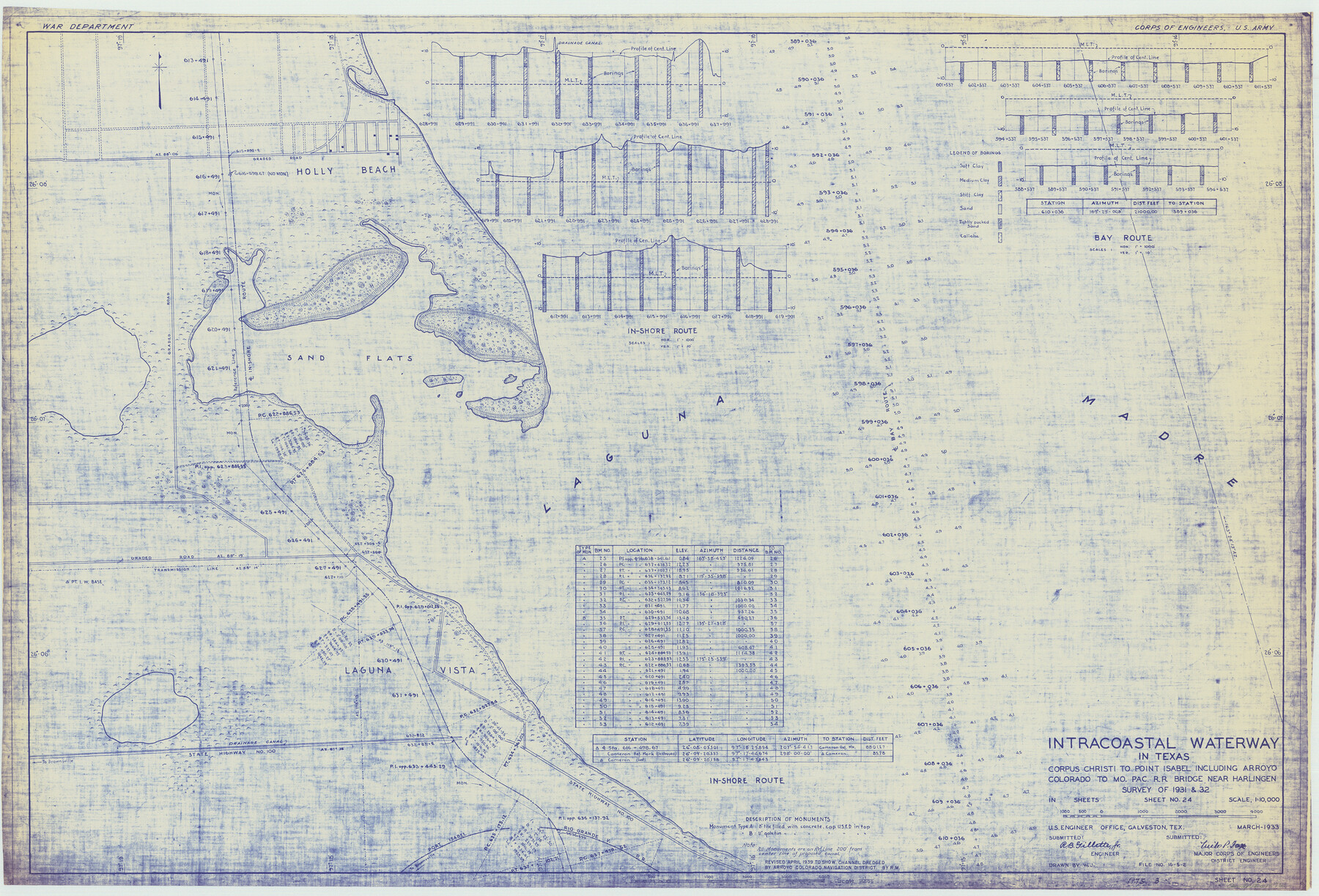
Intracoastal Waterway in Texas - Corpus Christi to Point Isabel including Arroyo Colorado to Mo. Pac. R.R. Bridge Near Harlingen
-
Map/Doc
61872
-
Collection
General Map Collection
-
Object Dates
1933 (Creation Date)
-
Subjects
Intracoastal Waterways
-
Height x Width
28.0 x 41.2 inches
71.1 x 104.6 cm
Part of: General Map Collection
San Jacinto County Working Sketch 12

Print $20.00
- Digital $50.00
San Jacinto County Working Sketch 12
1935
Size 33.4 x 37.3 inches
Map/Doc 63725
Flight Mission No. DQO-8K, Frame 39, Galveston County

Print $20.00
- Digital $50.00
Flight Mission No. DQO-8K, Frame 39, Galveston County
1952
Size 18.7 x 22.4 inches
Map/Doc 85146
Oldham County Sketch File 11

Print $26.00
- Digital $50.00
Oldham County Sketch File 11
Size 13.0 x 8.5 inches
Map/Doc 33247
Travis County Sketch File 71

Print $10.00
- Digital $50.00
Travis County Sketch File 71
1840
Size 12.9 x 8.3 inches
Map/Doc 38456
Jasper County Working Sketch 23

Print $20.00
- Digital $50.00
Jasper County Working Sketch 23
1944
Size 15.9 x 22.4 inches
Map/Doc 66485
Flight Mission No. DAH-9M, Frame 84, Orange County

Print $20.00
- Digital $50.00
Flight Mission No. DAH-9M, Frame 84, Orange County
1953
Size 18.7 x 22.5 inches
Map/Doc 86848
Red River County Working Sketch 74

Print $20.00
- Digital $50.00
Red River County Working Sketch 74
1980
Size 24.2 x 22.8 inches
Map/Doc 72057
Concho County Sketch File 52

Print $4.00
- Digital $50.00
Concho County Sketch File 52
1953
Size 14.5 x 8.9 inches
Map/Doc 19220
Jefferson County Sketch File 16

Print $4.00
- Digital $50.00
Jefferson County Sketch File 16
1870
Size 12.8 x 8.1 inches
Map/Doc 28163
Webb County Working Sketch 86

Print $20.00
- Digital $50.00
Webb County Working Sketch 86
1981
Size 44.3 x 37.0 inches
Map/Doc 72453
Day Ranch Lands, Leaday, Texas

Print $20.00
- Digital $50.00
Day Ranch Lands, Leaday, Texas
1948
Size 30.8 x 23.0 inches
Map/Doc 81516
Smith County Working Sketch 1

Print $20.00
- Digital $50.00
Smith County Working Sketch 1
Size 16.3 x 13.0 inches
Map/Doc 63886
You may also like
[Atlas D, Table of Contents]
![78350, [Atlas D, Table of Contents], General Map Collection](https://historictexasmaps.com/wmedia_w700/maps/78350.tif.jpg)
Print $20.00
- Digital $50.00
[Atlas D, Table of Contents]
Size 18.3 x 9.5 inches
Map/Doc 78350
Polk County Sketch File 37

Print $18.00
- Digital $50.00
Polk County Sketch File 37
1901
Size 9.1 x 8.1 inches
Map/Doc 34259

Oldham County Working Sketch 11

Print $20.00
- Digital $50.00
Oldham County Working Sketch 11
2014
Size 26.6 x 32.7 inches
Map/Doc 93686
Wavell Empresario Colony. Proposed, March 9, 1826

Print $20.00
Wavell Empresario Colony. Proposed, March 9, 1826
2020
Size 16.0 x 21.7 inches
Map/Doc 96009
[Surveys along the Bosque River]
![260, [Surveys along the Bosque River], General Map Collection](https://historictexasmaps.com/wmedia_w700/maps/260.tif.jpg)
Print $2.00
- Digital $50.00
[Surveys along the Bosque River]
1846
Size 9.3 x 7.8 inches
Map/Doc 260
Llano County Working Sketch 14

Print $20.00
- Digital $50.00
Llano County Working Sketch 14
1989
Size 14.6 x 34.7 inches
Map/Doc 70632

Brewster County Working Sketch 7

Print $20.00
- Digital $50.00
Brewster County Working Sketch 7
1909
Size 39.9 x 17.1 inches
Map/Doc 67540
Runnels County Rolled Sketch 41

Print $20.00
- Digital $50.00
Runnels County Rolled Sketch 41
Size 26.1 x 29.8 inches
Map/Doc 7529
Flight Mission No. DIX-10P, Frame 171, Aransas County

Print $20.00
- Digital $50.00
Flight Mission No. DIX-10P, Frame 171, Aransas County
1956
Size 18.8 x 22.3 inches
Map/Doc 83961
La Salle County Sketch File 32

Print $16.00
- Digital $50.00
La Salle County Sketch File 32
1883
Size 14.3 x 8.8 inches
Map/Doc 29576