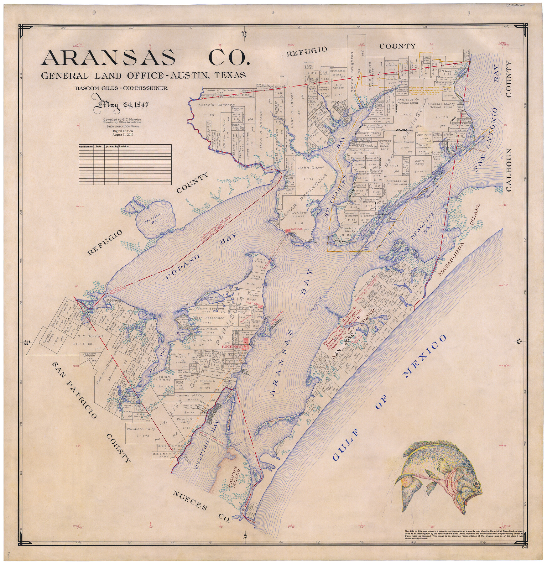
Aransas Co.
General Land Office Official County Map
-
Map/Doc
95418
-
Collection
General Map Collection
-
Object Dates
2019/8/31 (Revision Date)
1947/5/24 (Creation Date)
-
People and Organizations
Cheyenne Betancourt (Draftsman)
Eltea Armstrong (Draftsman)
G.C. Morriss (Compiler)
Bascom Giles (GLO Commissioner)
-
Counties
Aransas
-
Subjects
County OCM
-
Height x Width
38.6 x 37.4 inches
98.0 x 95.0 cm
-
Medium
digital image
-
Scale
1" = 2000 varas
Part of: General Map Collection
Travis County Rolled Sketch 40

Print $407.00
- Digital $50.00
Travis County Rolled Sketch 40
1953
Size 10.4 x 15.4 inches
Map/Doc 49195
Flight Mission No. DCL-6C, Frame 17, Kenedy County

Print $20.00
- Digital $50.00
Flight Mission No. DCL-6C, Frame 17, Kenedy County
1943
Size 18.6 x 22.4 inches
Map/Doc 85874
Hood County Working Sketch 6

Print $40.00
- Digital $50.00
Hood County Working Sketch 6
1969
Size 39.4 x 48.0 inches
Map/Doc 66200
Amistad International Reservoir on Rio Grande 95a

Print $20.00
- Digital $50.00
Amistad International Reservoir on Rio Grande 95a
1950
Size 28.8 x 41.2 inches
Map/Doc 75526
San Jacinto County Working Sketch 3

Print $20.00
- Digital $50.00
San Jacinto County Working Sketch 3
1926
Size 16.7 x 19.7 inches
Map/Doc 63716
Floyd County Sketch File 29

Print $20.00
- Digital $50.00
Floyd County Sketch File 29
Size 17.0 x 16.5 inches
Map/Doc 11488
Burleson County Working Sketch 36

Print $20.00
- Digital $50.00
Burleson County Working Sketch 36
1982
Size 31.0 x 33.3 inches
Map/Doc 67755
Colorado River, Bull Creek Sheet[/Champion 125 Acre Tract]
![65323, Colorado River, Bull Creek Sheet[/Champion 125 Acre Tract], General Map Collection](https://historictexasmaps.com/wmedia_w700/maps/65323.tif.jpg)
Print $6.00
- Digital $50.00
Colorado River, Bull Creek Sheet[/Champion 125 Acre Tract]
1934
Size 19.3 x 32.0 inches
Map/Doc 65323
Culberson County Sketch File 16

Print $20.00
- Digital $50.00
Culberson County Sketch File 16
Size 27.0 x 38.1 inches
Map/Doc 11268
Index for Texas Railroad ROW & track maps available on microfilm at THD & Archives and Records

Print $2.00
- Digital $50.00
Index for Texas Railroad ROW & track maps available on microfilm at THD & Archives and Records
1977
Size 11.3 x 8.8 inches
Map/Doc 60760
Val Verde County Sketch File L

Print $26.00
- Digital $50.00
Val Verde County Sketch File L
1919
Size 12.4 x 9.1 inches
Map/Doc 39262
La Salle County Sketch File 2

Print $14.00
- Digital $50.00
La Salle County Sketch File 2
1857
Size 10.1 x 15.5 inches
Map/Doc 29445
You may also like
Edwards County Sketch File 11

Print $26.00
- Digital $50.00
Edwards County Sketch File 11
1887
Size 13.7 x 8.8 inches
Map/Doc 21687
Galveston County NRC Article 33.136 Sketch 44

Print $22.00
- Digital $50.00
Galveston County NRC Article 33.136 Sketch 44
2007
Size 36.6 x 24.6 inches
Map/Doc 88352
Val Verde County Sketch File XX

Print $20.00
- Digital $50.00
Val Verde County Sketch File XX
Size 14.5 x 16.7 inches
Map/Doc 12546
Flight Mission No. CLL-3N, Frame 5, Willacy County

Print $20.00
- Digital $50.00
Flight Mission No. CLL-3N, Frame 5, Willacy County
1954
Size 18.4 x 22.1 inches
Map/Doc 87071

Sterling County Sketch File 25

Print $4.00
- Digital $50.00
Sterling County Sketch File 25
1892
Size 11.1 x 8.9 inches
Map/Doc 37192
Sketch showing progress of topographical work Laguna Madre and vicinity from Rainey Is. to Baffins Bay, Coast of Texas Sect. IX [and accompanying letter]
![72961, Sketch showing progress of topographical work Laguna Madre and vicinity from Rainey Is. to Baffins Bay, Coast of Texas Sect. IX [and accompanying letter], General Map Collection](https://historictexasmaps.com/wmedia_w700/maps/72961.tif.jpg)
Print $2.00
- Digital $50.00
Sketch showing progress of topographical work Laguna Madre and vicinity from Rainey Is. to Baffins Bay, Coast of Texas Sect. IX [and accompanying letter]
Size 11.1 x 8.7 inches
Map/Doc 72961
Flight Mission No. CGI-3N, Frame 163, Cameron County

Print $20.00
- Digital $50.00
Flight Mission No. CGI-3N, Frame 163, Cameron County
1954
Size 18.5 x 22.3 inches
Map/Doc 84627
Bosque County Sketch File 7

Print $4.00
- Digital $50.00
Bosque County Sketch File 7
1852
Size 12.7 x 7.7 inches
Map/Doc 14750
Index for Texas Railroad ROW & track maps available on microfilm at THD & Archives and Records

Print $2.00
- Digital $50.00
Index for Texas Railroad ROW & track maps available on microfilm at THD & Archives and Records
1977
Size 11.1 x 8.9 inches
Map/Doc 60755
Intracoastal Waterway in Texas - Corpus Christi to Point Isabel including Arroyo Colorado to Mo. Pac. R.R. Bridge Near Harlingen

Print $20.00
- Digital $50.00
Intracoastal Waterway in Texas - Corpus Christi to Point Isabel including Arroyo Colorado to Mo. Pac. R.R. Bridge Near Harlingen
1933
Size 28.0 x 41.0 inches
Map/Doc 61875
Map of the Southern States designed to accompany Smith's Geography for Schools

Print $20.00
- Digital $50.00
Map of the Southern States designed to accompany Smith's Geography for Schools
1850
Size 12.1 x 19.2 inches
Map/Doc 93888