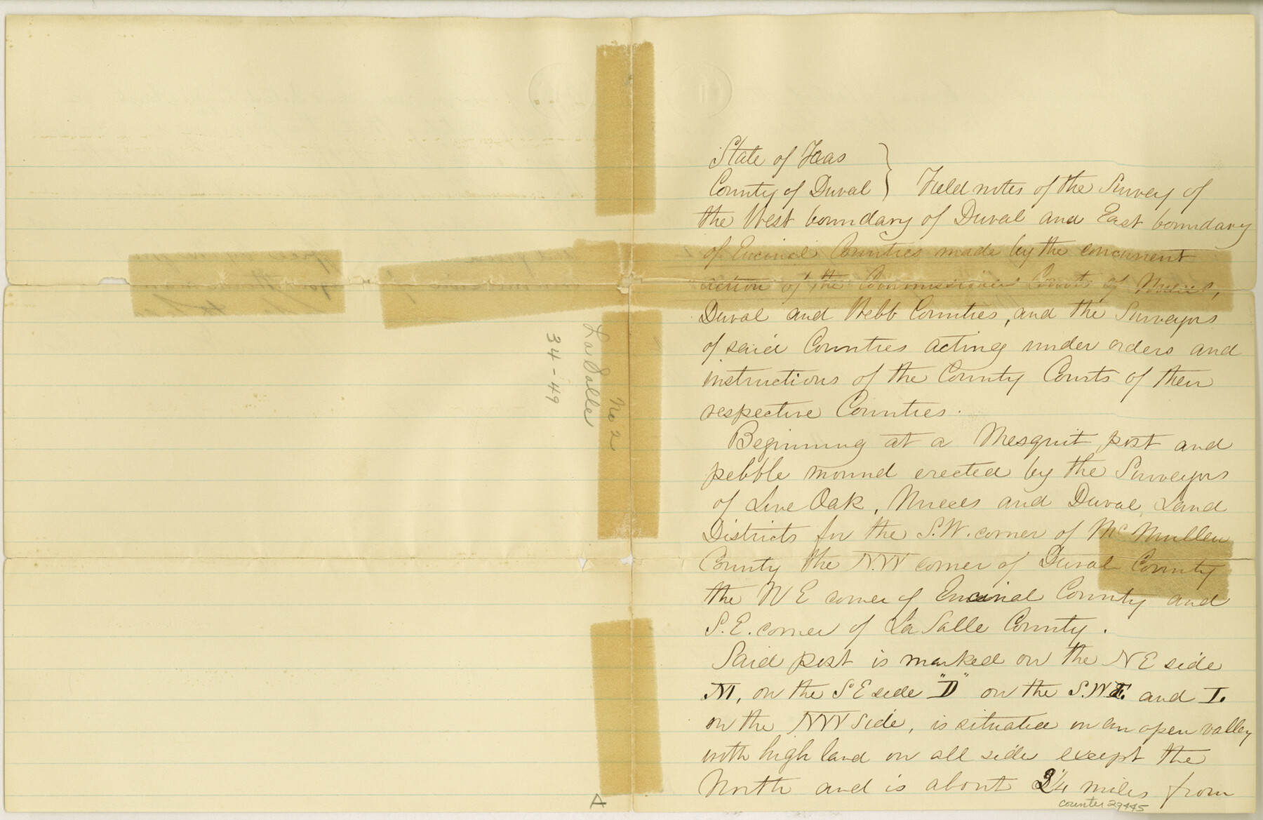
La Salle County Sketch File 2
[Sketch and field notes of surveys on Jahuey Creek]
-
Map/Doc
29445
-
Collection
General Map Collection
-
Object Dates
1857/7/30 (Creation Date)
1857/8/5 (File Date)
1877/9/17 (Survey Date)
1877/19/6 (Survey Date)
1877/12/24 (Correspondence Date)
-
People and Organizations
Francis Giraud (Surveyor/Engineer)
Lafayette Caldwell (Surveyor/Engineer)
-
Counties
La Salle Duval Encinal Webb
-
Subjects
Surveying Sketch File
-
Height x Width
10.1 x 15.5 inches
25.7 x 39.4 cm
-
Medium
paper, manuscript
-
Scale
1:4000
-
Features
Steele's Ranch
Magnujitos Hills
North Cheremusco Creek
South Fork of Cheremusco Creek
Corpus Christi and Eagle Pass Road
Jahuey Creek
Laredo Road
Part of: General Map Collection
Uvalde County Rolled Sketch 12

Print $20.00
- Digital $50.00
Uvalde County Rolled Sketch 12
1971
Size 28.5 x 40.4 inches
Map/Doc 8097
Stonewall County Rolled Sketch 32

Print $20.00
- Digital $50.00
Stonewall County Rolled Sketch 32
1951
Size 19.1 x 33.4 inches
Map/Doc 7877
Grayson County Working Sketch 8

Print $20.00
- Digital $50.00
Grayson County Working Sketch 8
1944
Size 19.8 x 16.7 inches
Map/Doc 63247

South Part Crockett County

Print $20.00
- Digital $50.00
South Part Crockett County
1977
Size 30.6 x 40.1 inches
Map/Doc 77254
Harris County NRC Article 33.136 Location Key Sheet

Print $20.00
- Digital $50.00
Harris County NRC Article 33.136 Location Key Sheet
1982
Size 27.0 x 22.5 inches
Map/Doc 77026
Kimble County Sketch File 28

Print $20.00
- Digital $50.00
Kimble County Sketch File 28
Size 23.3 x 17.8 inches
Map/Doc 11927
Bowie County Sketch File 7e

Print $10.00
- Digital $50.00
Bowie County Sketch File 7e
1927
Size 10.5 x 8.4 inches
Map/Doc 14867
Pecos County Rolled Sketch 173

Print $20.00
- Digital $50.00
Pecos County Rolled Sketch 173
Size 32.2 x 35.6 inches
Map/Doc 9751
Williamson County Rolled Sketch 5

Print $20.00
- Digital $50.00
Williamson County Rolled Sketch 5
1940
Size 23.7 x 34.5 inches
Map/Doc 8263
Presidio County Rolled Sketch 101

Print $20.00
- Digital $50.00
Presidio County Rolled Sketch 101
1954
Size 25.3 x 33.4 inches
Map/Doc 7383
Duval County Working Sketch 29

Print $20.00
- Digital $50.00
Duval County Working Sketch 29
1948
Size 28.9 x 31.5 inches
Map/Doc 68753
You may also like
Grayson County Working Sketch 17

Print $20.00
- Digital $50.00
Grayson County Working Sketch 17
1955
Size 16.0 x 42.5 inches
Map/Doc 63256
Webb County Sketch File 53

Print $20.00
- Digital $50.00
Webb County Sketch File 53
1939
Size 18.7 x 14.5 inches
Map/Doc 12649
Calhoun County NRC Article 33.136 Location Key Sheet

Print $20.00
- Digital $50.00
Calhoun County NRC Article 33.136 Location Key Sheet
1973
Size 27.0 x 23.0 inches
Map/Doc 87907
[Sketch for Mineral Application 24072, San Jacinto River]
![65609, [Sketch for Mineral Application 24072, San Jacinto River], General Map Collection](https://historictexasmaps.com/wmedia_w700/maps/65609.tif.jpg)
Print $20.00
- Digital $50.00
[Sketch for Mineral Application 24072, San Jacinto River]
1929
Size 8.4 x 13.9 inches
Map/Doc 65609
Refugio County Sketch File 2

Print $6.00
- Digital $50.00
Refugio County Sketch File 2
1846
Size 12.6 x 7.7 inches
Map/Doc 35238
United States - Gulf Coast Texas - Southern part of Laguna Madre

Print $20.00
- Digital $50.00
United States - Gulf Coast Texas - Southern part of Laguna Madre
1941
Size 26.6 x 18.2 inches
Map/Doc 72941
Dickens County Sketch File 8

Print $4.00
- Digital $50.00
Dickens County Sketch File 8
Size 8.8 x 14.2 inches
Map/Doc 20971
Upper Galveston Bay, Houston Ship Channel, Dollar Pt. to Atkinson I.

Print $40.00
- Digital $50.00
Upper Galveston Bay, Houston Ship Channel, Dollar Pt. to Atkinson I.
1972
Size 49.9 x 36.9 inches
Map/Doc 69895
Flight Mission No. BQR-9K, Frame 4, Brazoria County

Print $20.00
- Digital $50.00
Flight Mission No. BQR-9K, Frame 4, Brazoria County
1952
Size 18.8 x 22.3 inches
Map/Doc 84033
San Augustine County Sketch File 9

Print $4.00
San Augustine County Sketch File 9
1860
Size 12.6 x 7.6 inches
Map/Doc 35650
Brooks County Sketch File 9

Print $2.00
- Digital $50.00
Brooks County Sketch File 9
1988
Size 14.4 x 8.8 inches
Map/Doc 16571
New Road Between Virginia Point and the City of Houston

Print $20.00
- Digital $50.00
New Road Between Virginia Point and the City of Houston
1843
Size 14.5 x 20.7 inches
Map/Doc 34