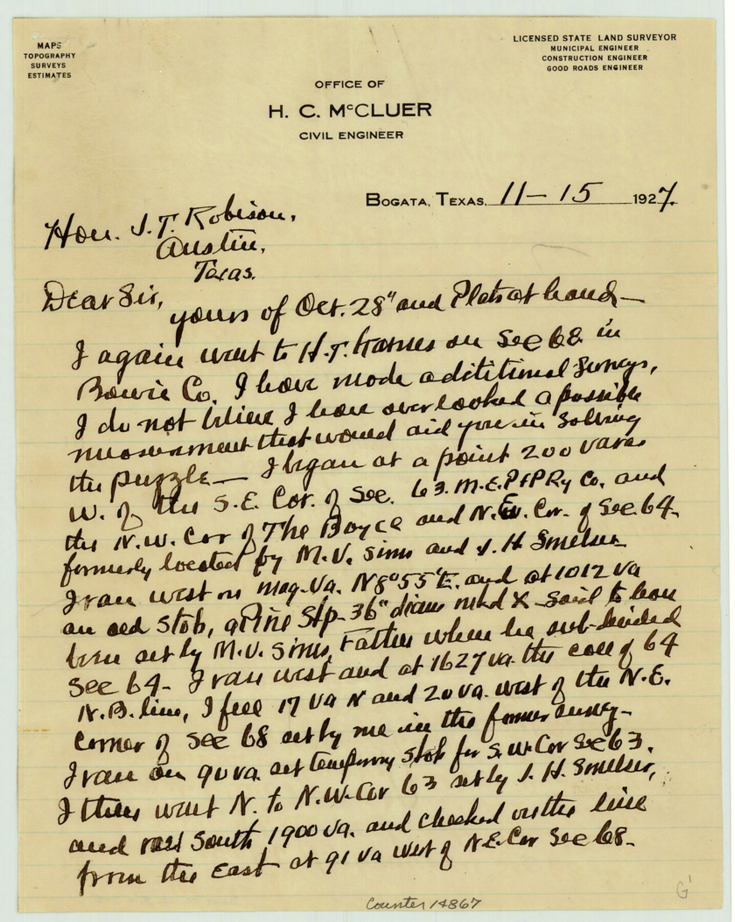
Bowie County Sketch File 7e
[H.C. McCluer's statement about section 68, T. & P. R.R. Co.]
-
Map/Doc
14867
-
Collection
General Map Collection
-
Object Dates
1927/11/15 (Creation Date)
-
People and Organizations
H.C. McCluer (Surveyor/Engineer)
-
Counties
Bowie
-
Subjects
Surveying Sketch File
-
Height x Width
10.5 x 8.4 inches
26.7 x 21.3 cm
-
Medium
paper, manuscript
Part of: General Map Collection
Montague County Boundary File 2d

Print $4.00
- Digital $50.00
Montague County Boundary File 2d
Size 12.5 x 8.2 inches
Map/Doc 57432

St. Louis, Brownsville & Mexico Railway Location Map from Mile 100 to Mile 120

Print $40.00
- Digital $50.00
St. Louis, Brownsville & Mexico Railway Location Map from Mile 100 to Mile 120
1905
Size 20.0 x 61.2 inches
Map/Doc 64167
[F. W. & D. C. Ry. Co. Alignment and Right of Way Map, Clay County]
![64734, [F. W. & D. C. Ry. Co. Alignment and Right of Way Map, Clay County], General Map Collection](https://historictexasmaps.com/wmedia_w700/maps/64734-GC.tif.jpg)
Print $20.00
- Digital $50.00
[F. W. & D. C. Ry. Co. Alignment and Right of Way Map, Clay County]
1927
Size 18.6 x 11.8 inches
Map/Doc 64734
Bandera County Boundary File 5

Print $44.00
- Digital $50.00
Bandera County Boundary File 5
Size 14.2 x 8.7 inches
Map/Doc 50299
Edwards County Working Sketch 54

Print $20.00
- Digital $50.00
Edwards County Working Sketch 54
1951
Size 19.2 x 28.5 inches
Map/Doc 68930
Pecos County Rolled Sketch 56

Print $20.00
- Digital $50.00
Pecos County Rolled Sketch 56
1916
Size 18.1 x 24.2 inches
Map/Doc 5229
Coleman County Working Sketch Graphic Index

Print $40.00
- Digital $50.00
Coleman County Working Sketch Graphic Index
1945
Size 54.0 x 36.3 inches
Map/Doc 76497
Pressler's Map of the State of Texas

Print $40.00
- Digital $50.00
Pressler's Map of the State of Texas
1858
Size 47.6 x 51.9 inches
Map/Doc 709
Guadalupe County

Print $20.00
- Digital $50.00
Guadalupe County
1977
Size 35.9 x 46.4 inches
Map/Doc 73165
Pecos County Rolled Sketch 152

Print $20.00
- Digital $50.00
Pecos County Rolled Sketch 152
1960
Size 38.8 x 43.7 inches
Map/Doc 9736
Terry County Boundary File 4a

Print $70.00
- Digital $50.00
Terry County Boundary File 4a
Size 11.4 x 8.8 inches
Map/Doc 59249
You may also like
Webb County Working Sketch 85

Print $20.00
- Digital $50.00
Webb County Working Sketch 85
1981
Size 21.1 x 29.0 inches
Map/Doc 72452
[Gulf, Colorado & Santa Fe]
![64591, [Gulf, Colorado & Santa Fe], General Map Collection](https://historictexasmaps.com/wmedia_w700/maps/64591.tif.jpg)
Print $40.00
- Digital $50.00
[Gulf, Colorado & Santa Fe]
1918
Size 63.1 x 31.2 inches
Map/Doc 64591
Brown County Rolled Sketch 2C

Print $20.00
- Digital $50.00
Brown County Rolled Sketch 2C
1984
Size 26.7 x 24.6 inches
Map/Doc 5352
Flight Mission No. DIX-7P, Frame 87, Aransas County

Print $20.00
- Digital $50.00
Flight Mission No. DIX-7P, Frame 87, Aransas County
1956
Size 18.7 x 22.4 inches
Map/Doc 83881
Red River County Sketch File 14

Print $8.00
- Digital $50.00
Red River County Sketch File 14
Size 13.7 x 9.0 inches
Map/Doc 35133
Fractional Township No. 7 South Range No. 7 West of the Indian Meridian, Indian Territory

Print $20.00
- Digital $50.00
Fractional Township No. 7 South Range No. 7 West of the Indian Meridian, Indian Territory
1898
Size 19.2 x 24.4 inches
Map/Doc 75168
General Highway Map, Bexar County, Texas

Print $20.00
General Highway Map, Bexar County, Texas
1961
Size 18.4 x 25.0 inches
Map/Doc 79370
Brewster County Rolled Sketch 114

Print $20.00
- Digital $50.00
Brewster County Rolled Sketch 114
1964
Size 11.5 x 18.5 inches
Map/Doc 5271
[John Walker, south part B9 and vicinity]
![90330, [John Walker, south part B9 and vicinity], Twichell Survey Records](https://historictexasmaps.com/wmedia_w700/maps/90330-1.tif.jpg)
Print $20.00
- Digital $50.00
[John Walker, south part B9 and vicinity]
Size 32.7 x 24.1 inches
Map/Doc 90330
[Sketch showing B. S. & F. Blks B1 and B2 and surrounding Blocks]
![90137, [Sketch showing B. S. & F. Blks B1 and B2 and surrounding Blocks], Twichell Survey Records](https://historictexasmaps.com/wmedia_w700/maps/90137-1.tif.jpg)
Print $20.00
- Digital $50.00
[Sketch showing B. S. & F. Blks B1 and B2 and surrounding Blocks]
Size 23.3 x 18.3 inches
Map/Doc 90137
Stephens County Working Sketch 20

Print $20.00
- Digital $50.00
Stephens County Working Sketch 20
1972
Size 26.7 x 30.6 inches
Map/Doc 63963
Liberty County Sketch File 32

Print $8.00
- Digital $50.00
Liberty County Sketch File 32
1872
Size 10.3 x 8.2 inches
Map/Doc 29961