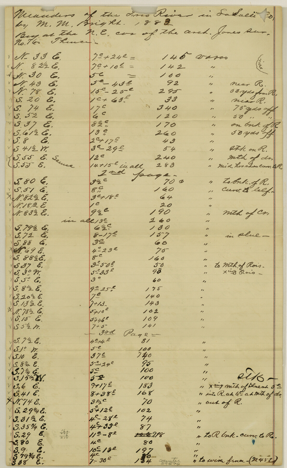
La Salle County Sketch File 32
[Meanders of the Frio River]
-
Map/Doc
29576
-
Collection
General Map Collection
-
Object Dates
1883 (Creation Date)
-
People and Organizations
M.M. Bright (Surveyor/Engineer)
-
Counties
La Salle
-
Subjects
Surveying Sketch File
-
Height x Width
14.3 x 8.8 inches
36.3 x 22.4 cm
-
Medium
paper, manuscript
-
Features
Frio River
Part of: General Map Collection
Brazoria County Rolled Sketch 45

Print $4.00
- Digital $50.00
Brazoria County Rolled Sketch 45
1885
Size 23.0 x 28.5 inches
Map/Doc 5179

Deaf Smith County Rolled Sketch 1

Print $20.00
- Digital $50.00
Deaf Smith County Rolled Sketch 1
1965
Size 24.8 x 25.9 inches
Map/Doc 5698
Flight Mission No. BQY-4M, Frame 69, Harris County

Print $20.00
- Digital $50.00
Flight Mission No. BQY-4M, Frame 69, Harris County
1953
Size 18.6 x 22.4 inches
Map/Doc 85278

Map of San Leon, Amos Edwards League, Galveston County, Texas

Print $20.00
- Digital $50.00
Map of San Leon, Amos Edwards League, Galveston County, Texas
1911
Size 22.9 x 14.1 inches
Map/Doc 3037
Garza County Rolled Sketch 6C

Print $20.00
- Digital $50.00
Garza County Rolled Sketch 6C
Size 24.7 x 19.2 inches
Map/Doc 5997
Map of Scurry County

Print $20.00
- Digital $50.00
Map of Scurry County
1899
Size 39.8 x 34.7 inches
Map/Doc 63029
Wood County Working Sketch 13

Print $20.00
- Digital $50.00
Wood County Working Sketch 13
1973
Size 23.1 x 20.2 inches
Map/Doc 62013
Flight Mission No. BRE-2P, Frame 64, Nueces County

Print $20.00
- Digital $50.00
Flight Mission No. BRE-2P, Frame 64, Nueces County
1956
Size 18.5 x 22.6 inches
Map/Doc 86759
Wichita County Rolled Sketch 9A

Print $20.00
- Digital $50.00
Wichita County Rolled Sketch 9A
1917
Size 32.4 x 27.9 inches
Map/Doc 8247
Dimmit County Boundary File 9

Print $20.00
- Digital $50.00
Dimmit County Boundary File 9
Size 37.2 x 6.9 inches
Map/Doc 52603
You may also like
The Judicial District/County of Guadalupe. Abolished, Spring 1842

Print $20.00
The Judicial District/County of Guadalupe. Abolished, Spring 1842
2020
Size 16.7 x 21.7 inches
Map/Doc 96328
Bell County Working Sketch 2

Print $20.00
- Digital $50.00
Bell County Working Sketch 2
1938
Size 25.8 x 28.8 inches
Map/Doc 67342
[Famous Heights Addition to Amarillo, Texas]
![91786, [Famous Heights Addition to Amarillo, Texas], Twichell Survey Records](https://historictexasmaps.com/wmedia_w700/maps/91786-1.tif.jpg)
Print $20.00
- Digital $50.00
[Famous Heights Addition to Amarillo, Texas]
Size 20.3 x 15.6 inches
Map/Doc 91786
Terrell County Working Sketch Graphic Index - sheet A

Print $20.00
- Digital $50.00
Terrell County Working Sketch Graphic Index - sheet A
1931
Size 47.9 x 39.2 inches
Map/Doc 76710
San Augustine County Sketch File 7

Print $4.00
San Augustine County Sketch File 7
1858
Size 7.0 x 8.2 inches
Map/Doc 35646
Nueces County Sketch File 35

Print $2.00
- Digital $50.00
Nueces County Sketch File 35
1913
Size 13.1 x 4.8 inches
Map/Doc 32613
Colorado County Working Sketch 20

Print $20.00
- Digital $50.00
Colorado County Working Sketch 20
1963
Size 27.9 x 24.7 inches
Map/Doc 68120
[Surveys in Austin's Colony on both sides of the Navidad River]
![217, [Surveys in Austin's Colony on both sides of the Navidad River], General Map Collection](https://historictexasmaps.com/wmedia_w700/maps/217.tif.jpg)
Print $20.00
- Digital $50.00
[Surveys in Austin's Colony on both sides of the Navidad River]
1831
Size 18.8 x 12.7 inches
Map/Doc 217
Martin County Working Sketch 9

Print $20.00
- Digital $50.00
Martin County Working Sketch 9
1971
Size 45.2 x 38.1 inches
Map/Doc 70827
Jeff Davis County Working Sketch 19

Print $40.00
- Digital $50.00
Jeff Davis County Working Sketch 19
1957
Size 71.3 x 34.1 inches
Map/Doc 66514
Map of the East Part of Tom Green County

Print $40.00
- Digital $50.00
Map of the East Part of Tom Green County
1894
Size 45.9 x 49.4 inches
Map/Doc 63071
Gray County Boundary File 7

Print $4.00
- Digital $50.00
Gray County Boundary File 7
Size 8.0 x 8.8 inches
Map/Doc 53898