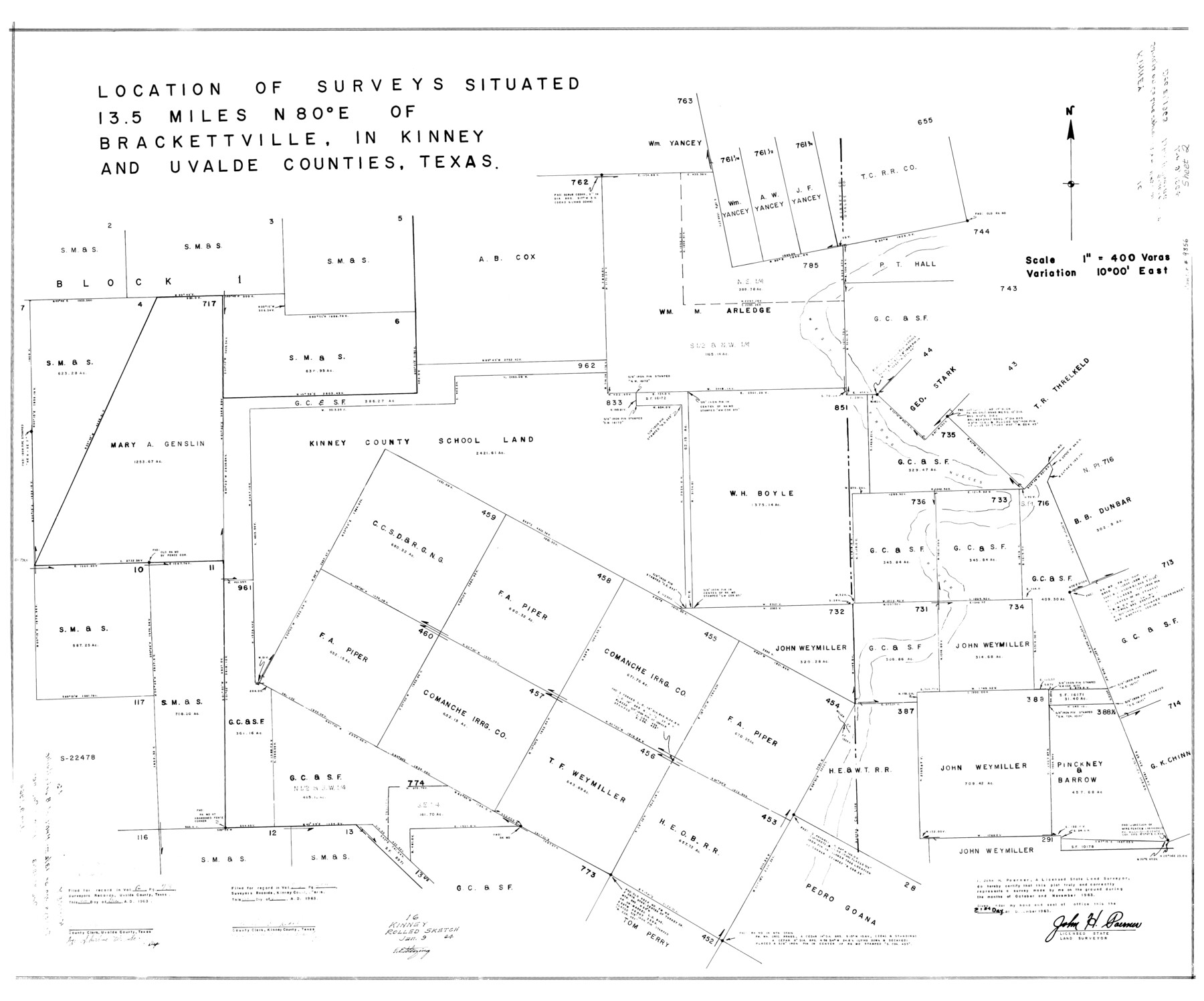
Kinney County Rolled Sketch 16
Location of surveys situated in Kinney and Uvalde Counties, east of Brackettville
-
Map/Doc
9356
-
Collection
General Map Collection
-
Object Dates
1963/12/21 (Creation Date)
1964/1/9 (File Date)
-
People and Organizations
John H. Poerner (Surveyor/Engineer)
-
Counties
Kinney Uvalde
-
Subjects
Surveying Rolled Sketch
-
Height x Width
36.4 x 43.8 inches
92.5 x 111.3 cm
-
Scale
1" = 400 varas
Part of: General Map Collection
The Great European Alliance against the Mexican Republic

Print $20.00
- Digital $50.00
The Great European Alliance against the Mexican Republic
1861
Size 22.9 x 16.2 inches
Map/Doc 96429
Fort Bend County Sketch File 17 1/2

Print $52.00
- Digital $50.00
Fort Bend County Sketch File 17 1/2
1896
Size 11.2 x 8.7 inches
Map/Doc 22934
Donley County Sketch File 19

Print $20.00
- Digital $50.00
Donley County Sketch File 19
Size 20.4 x 8.4 inches
Map/Doc 11366
Lynn County Boundary File 2

Print $6.00
- Digital $50.00
Lynn County Boundary File 2
Size 11.1 x 8.7 inches
Map/Doc 56620
Tarrant County Working Sketch 1

Print $20.00
- Digital $50.00
Tarrant County Working Sketch 1
1939
Size 12.2 x 18.9 inches
Map/Doc 62418
Crockett County Sketch File 39

Print $20.00
- Digital $50.00
Crockett County Sketch File 39
1889
Size 19.7 x 32.6 inches
Map/Doc 11221
Dickens County Sketch File 18aa

Print $20.00
- Digital $50.00
Dickens County Sketch File 18aa
Size 17.2 x 18.2 inches
Map/Doc 11323
Jefferson County Working Sketch 17

Print $20.00
- Digital $50.00
Jefferson County Working Sketch 17
1954
Size 47.1 x 30.3 inches
Map/Doc 66560
Liberty County Sketch File AX

Print $10.00
- Digital $50.00
Liberty County Sketch File AX
1899
Size 14.1 x 8.5 inches
Map/Doc 30061
Pecos County Rolled Sketch 16

Print $40.00
- Digital $50.00
Pecos County Rolled Sketch 16
1882
Size 42.0 x 65.9 inches
Map/Doc 9682
Clay County Sketch File 17

Print $4.00
- Digital $50.00
Clay County Sketch File 17
1855
Size 6.8 x 8.7 inches
Map/Doc 18425
Polk County Sketch File 17

Print $4.00
- Digital $50.00
Polk County Sketch File 17
1861
Size 8.1 x 9.5 inches
Map/Doc 34163
You may also like
Jefferson County Sketch File 48

Print $20.00
- Digital $50.00
Jefferson County Sketch File 48
1875
Size 19.8 x 21.0 inches
Map/Doc 11882
Township 4 South Ranges 12 and 13 West, South Western District, Louisiana

Print $20.00
- Digital $50.00
Township 4 South Ranges 12 and 13 West, South Western District, Louisiana
1857
Size 18.6 x 24.2 inches
Map/Doc 65891
Anderson County Sketch File 7

Print $4.00
- Digital $50.00
Anderson County Sketch File 7
Size 7.9 x 10.0 inches
Map/Doc 12757
Webb County Rolled Sketch 29

Print $20.00
- Digital $50.00
Webb County Rolled Sketch 29
1932
Size 16.5 x 15.3 inches
Map/Doc 8187
Wise County Sketch File 51

Print $2.00
- Digital $50.00
Wise County Sketch File 51
Size 8.5 x 3.9 inches
Map/Doc 40618
Flight Mission No. BRA-16M, Frame 89, Jefferson County

Print $20.00
- Digital $50.00
Flight Mission No. BRA-16M, Frame 89, Jefferson County
1953
Size 18.6 x 22.4 inches
Map/Doc 85701
Webb County Rolled Sketch 9

Print $20.00
- Digital $50.00
Webb County Rolled Sketch 9
1905
Size 12.6 x 16.3 inches
Map/Doc 8175
Collin County Sketch File 4

Print $4.00
- Digital $50.00
Collin County Sketch File 4
1856
Size 10.0 x 8.0 inches
Map/Doc 18862
Jeff Davis County Rolled Sketch 32

Print $20.00
- Digital $50.00
Jeff Davis County Rolled Sketch 32
1984
Size 16.3 x 24.5 inches
Map/Doc 7721
Hemphill County Working Sketch 33

Print $20.00
- Digital $50.00
Hemphill County Working Sketch 33
1976
Size 39.6 x 32.3 inches
Map/Doc 66128
Navarro County Sketch File 18

Print $3.00
- Digital $50.00
Navarro County Sketch File 18
1871
Size 10.6 x 10.0 inches
Map/Doc 32335
Hays County Sketch File 27

Print $6.00
- Digital $50.00
Hays County Sketch File 27
Size 11.2 x 8.8 inches
Map/Doc 26252