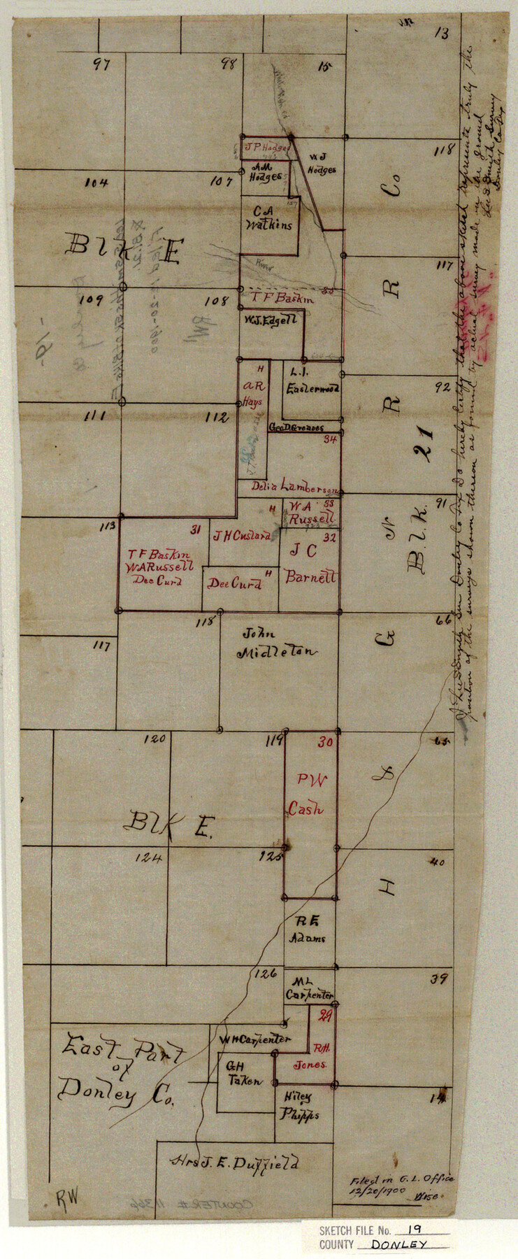
Donley County Sketch File 19
Lee S. Smith's Sk. of Blks. E & Bl. 21
-
Map/Doc
11366
-
Collection
General Map Collection
-
Object Dates
1900/12/20 (File Date)
-
People and Organizations
Lee S. Smith (Surveyor/Engineer)
-
Counties
Donley
-
Subjects
Surveying Sketch File
-
Height x Width
20.4 x 8.4 inches
51.8 x 21.3 cm
-
Medium
paper, manuscript
-
Features
White Fish Creek
Part of: General Map Collection
[St. L. S-W. Ry. of Texas Map of Lufkin Branch in Cherokee County Texas]
![64018, [St. L. S-W. Ry. of Texas Map of Lufkin Branch in Cherokee County Texas], General Map Collection](https://historictexasmaps.com/wmedia_w700/maps/64018.tif.jpg)
Print $40.00
- Digital $50.00
[St. L. S-W. Ry. of Texas Map of Lufkin Branch in Cherokee County Texas]
1912
Size 22.3 x 121.1 inches
Map/Doc 64018
Flight Mission No. CLL-1N, Frame 12, Willacy County

Print $20.00
- Digital $50.00
Flight Mission No. CLL-1N, Frame 12, Willacy County
1954
Size 18.4 x 22.1 inches
Map/Doc 86999
Reagan County Working Sketch 41
Print $20.00
- Digital $50.00
Reagan County Working Sketch 41
1973
Size 28.6 x 38.9 inches
Map/Doc 71883
Hamilton County Working Sketch 2

Print $20.00
- Digital $50.00
Hamilton County Working Sketch 2
1923
Size 12.9 x 15.7 inches
Map/Doc 63340
Denton County Working Sketch 2

Print $20.00
- Digital $50.00
Denton County Working Sketch 2
Size 21.2 x 17.7 inches
Map/Doc 68607
Mitchell County Boundary File 66a

Print $11.00
- Digital $50.00
Mitchell County Boundary File 66a
Size 12.6 x 8.3 inches
Map/Doc 57378

Jasper County Working Sketch 14

Print $40.00
- Digital $50.00
Jasper County Working Sketch 14
1920
Size 37.9 x 55.1 inches
Map/Doc 66476
Carson County Boundary File 6

Print $48.00
- Digital $50.00
Carson County Boundary File 6
Size 12.8 x 8.3 inches
Map/Doc 51151
Calhoun County Rolled Sketch 11

Print $3.00
- Digital $50.00
Calhoun County Rolled Sketch 11
1942
Size 10.8 x 16.3 inches
Map/Doc 5464
Map of Texas Compiled from surveys on record in the General Land Office of the Republic to the year 1839

Print $20.00
- Digital $50.00
Map of Texas Compiled from surveys on record in the General Land Office of the Republic to the year 1839
1891
Size 36.6 x 25.7 inches
Map/Doc 1891
Culberson County Working Sketch 67

Print $40.00
- Digital $50.00
Culberson County Working Sketch 67
1975
Size 48.9 x 33.2 inches
Map/Doc 68521
You may also like
Sutton County

Print $40.00
- Digital $50.00
Sutton County
1941
Size 40.9 x 54.3 inches
Map/Doc 77429
[H. & G. N. Block 1]
![90944, [H. & G. N. Block 1], Twichell Survey Records](https://historictexasmaps.com/wmedia_w700/maps/90944-1.tif.jpg)
Print $20.00
- Digital $50.00
[H. & G. N. Block 1]
1873
Size 17.7 x 14.3 inches
Map/Doc 90944

Montague County Rolled Sketch 9

Print $20.00
- Digital $50.00
Montague County Rolled Sketch 9
Size 29.1 x 39.4 inches
Map/Doc 6793
Flight Mission No. DIX-6P, Frame 124, Aransas County

Print $20.00
- Digital $50.00
Flight Mission No. DIX-6P, Frame 124, Aransas County
1956
Size 19.0 x 22.4 inches
Map/Doc 83830
Greater San Antonio & Surrounding Area

Greater San Antonio & Surrounding Area
Size 36.1 x 46.0 inches
Map/Doc 96869
General Highway Map, Potter County, Texas

Print $20.00
General Highway Map, Potter County, Texas
1940
Size 24.6 x 18.3 inches
Map/Doc 79220
Flight Mission No. BRE-1P, Frame 143, Nueces County

Print $20.00
- Digital $50.00
Flight Mission No. BRE-1P, Frame 143, Nueces County
1956
Size 18.3 x 22.2 inches
Map/Doc 86703
Texas Official Highway Travel Map

Digital $50.00
Texas Official Highway Travel Map
Size 27.2 x 36.2 inches
Map/Doc 94305
Reagan County Working Sketch 47

Print $20.00
- Digital $50.00
Reagan County Working Sketch 47
1987
Size 23.9 x 43.8 inches
Map/Doc 71890
![91820, [Block M-19], Twichell Survey Records](https://historictexasmaps.com/wmedia_w700/maps/91820-1.tif.jpg)
Dawson County Sketch File 21

Print $20.00
- Digital $50.00
Dawson County Sketch File 21
1953
Size 12.2 x 24.5 inches
Map/Doc 11297