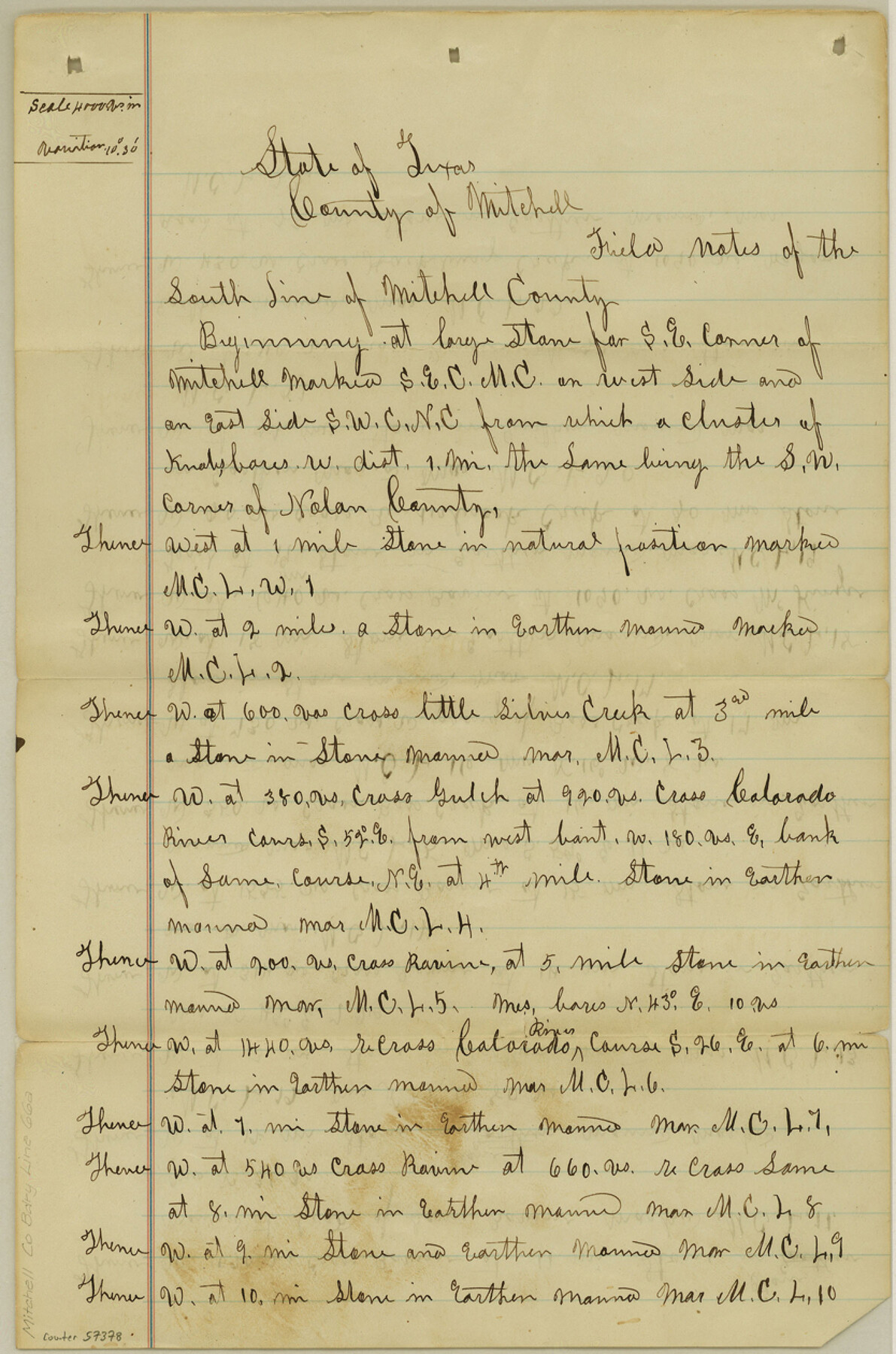
Mitchell County Boundary File 66a
Field notes South line Mitchell County
-
Map/Doc
57378
-
Collection
General Map Collection
-
Counties
Mitchell
-
Subjects
County Boundaries
-
Height x Width
12.6 x 8.3 inches
32.0 x 21.1 cm
Part of: General Map Collection
Flight Mission No. CUG-3P, Frame 41, Kleberg County

Print $20.00
- Digital $50.00
Flight Mission No. CUG-3P, Frame 41, Kleberg County
1956
Size 18.3 x 22.1 inches
Map/Doc 86246
Flight Mission No. DIX-8P, Frame 60, Aransas County

Print $20.00
- Digital $50.00
Flight Mission No. DIX-8P, Frame 60, Aransas County
1956
Size 18.5 x 22.2 inches
Map/Doc 83891
Flight Mission No. DQN-5K, Frame 31, Calhoun County

Print $20.00
- Digital $50.00
Flight Mission No. DQN-5K, Frame 31, Calhoun County
1953
Size 18.5 x 22.1 inches
Map/Doc 84382
Willacy County Aerial Photograph Index Sheet 2

Print $20.00
- Digital $50.00
Willacy County Aerial Photograph Index Sheet 2
1940
Size 24.3 x 20.2 inches
Map/Doc 83757
Ward County Rolled Sketch 1

Print $20.00
- Digital $50.00
Ward County Rolled Sketch 1
1888
Size 41.7 x 11.6 inches
Map/Doc 76166
Presidio County Boundary File 3a

Print $40.00
- Digital $50.00
Presidio County Boundary File 3a
Size 17.7 x 38.0 inches
Map/Doc 58074
Dimmit County Working Sketch 41

Print $20.00
- Digital $50.00
Dimmit County Working Sketch 41
1971
Size 26.1 x 27.0 inches
Map/Doc 68702
Brewster County Sketch File 47

Print $12.00
- Digital $50.00
Brewster County Sketch File 47
1939
Size 14.1 x 8.8 inches
Map/Doc 16321
Brazoria County Sketch File 53

Print $14.00
- Digital $50.00
Brazoria County Sketch File 53
1919
Size 14.2 x 8.6 inches
Map/Doc 15316
Coryell County Boundary File 2

Print $4.00
- Digital $50.00
Coryell County Boundary File 2
Size 5.6 x 8.2 inches
Map/Doc 51905
Crane County Working Sketch 33

Print $20.00
- Digital $50.00
Crane County Working Sketch 33
1985
Size 30.3 x 27.6 inches
Map/Doc 68310
Reeves County Sketch File 22

Print $4.00
- Digital $50.00
Reeves County Sketch File 22
Size 14.3 x 8.7 inches
Map/Doc 35220
You may also like
Motley County Sketch File 7 (S)

Print $4.00
- Digital $50.00
Motley County Sketch File 7 (S)
Size 8.1 x 9.6 inches
Map/Doc 32149
King County Working Sketch 6

Print $20.00
- Digital $50.00
King County Working Sketch 6
1944
Size 11.5 x 18.3 inches
Map/Doc 70170
Madison County Working Sketch 14

Print $20.00
- Digital $50.00
Madison County Working Sketch 14
Size 24.9 x 17.0 inches
Map/Doc 78204

Map of Bexar County

Print $20.00
- Digital $50.00
Map of Bexar County
1878
Size 24.5 x 27.6 inches
Map/Doc 3298
Cottle County Sketch File 16a

Print $64.00
- Digital $50.00
Cottle County Sketch File 16a
1911
Size 11.5 x 8.9 inches
Map/Doc 19522
Hartley County Sketch File 2

Print $22.00
- Digital $50.00
Hartley County Sketch File 2
Size 8.9 x 13.6 inches
Map/Doc 26085
Yoakum County Boundary File 1a

Print $20.00
- Digital $50.00
Yoakum County Boundary File 1a
Size 7.8 x 29.5 inches
Map/Doc 60196
Orange County Working Sketch Graphic Index - sheet A

Print $20.00
- Digital $50.00
Orange County Working Sketch Graphic Index - sheet A
1921
Size 24.4 x 29.3 inches
Map/Doc 76658
San Augustine County Working Sketch 24

Print $20.00
- Digital $50.00
San Augustine County Working Sketch 24
1975
Size 27.8 x 39.1 inches
Map/Doc 63712
Flight Mission No. DCL-7C, Frame 96, Kenedy County

Print $20.00
- Digital $50.00
Flight Mission No. DCL-7C, Frame 96, Kenedy County
1943
Size 15.4 x 15.2 inches
Map/Doc 86068
Coast Chart No. 212 - From Latitude 26° 33' to the Rio Grande Texas

Print $20.00
- Digital $50.00
Coast Chart No. 212 - From Latitude 26° 33' to the Rio Grande Texas
1886
Size 18.4 x 27.8 inches
Map/Doc 72826