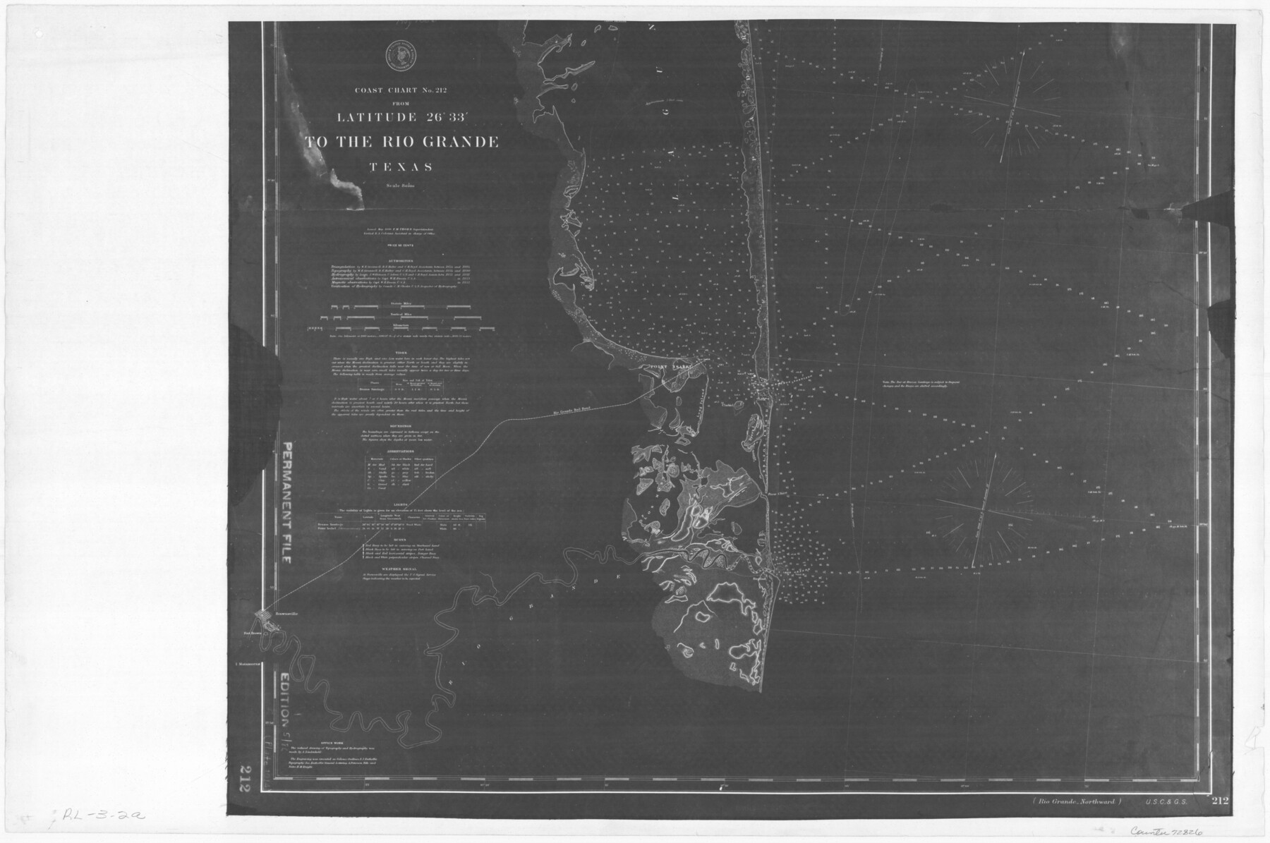
Coast Chart No. 212 - From Latitude 26° 33' to the Rio Grande Texas
RL-3-2a
-
Map/Doc
72826
-
Collection
General Map Collection
-
Object Dates
1886 (Creation Date)
-
People and Organizations
U. S. Coastal and Geodetic Survey (Publisher)
A. Lindenkohl (Draftsman)
-
Subjects
Nautical Charts
-
Height x Width
18.4 x 27.8 inches
46.7 x 70.6 cm
-
Comments
B/W photostat copy from National Archives in multiple pieces.
Part of: General Map Collection
Sutton County Sketch File X

Print $24.00
- Digital $50.00
Sutton County Sketch File X
1915
Size 14.3 x 8.8 inches
Map/Doc 37451
Terry County Sketch File 10

Print $20.00
- Digital $50.00
Terry County Sketch File 10
Size 10.8 x 43.2 inches
Map/Doc 10394
Garza County Sketch File 28

Print $6.00
- Digital $50.00
Garza County Sketch File 28
1935
Size 11.2 x 8.8 inches
Map/Doc 24097
Kent County Boundary File 3

Print $8.00
- Digital $50.00
Kent County Boundary File 3
Size 11.2 x 8.6 inches
Map/Doc 55824
Flight Mission No. BRA-8M, Frame 123, Jefferson County

Print $20.00
- Digital $50.00
Flight Mission No. BRA-8M, Frame 123, Jefferson County
1953
Size 18.7 x 22.3 inches
Map/Doc 85619

Cameron County Rolled Sketch 25

Print $20.00
- Digital $50.00
Cameron County Rolled Sketch 25
1977
Size 24.8 x 36.8 inches
Map/Doc 5792
Classification of Blocks 1 to 58, Set Apart to University by Constitution of 1876 by M. B. Moore

Classification of Blocks 1 to 58, Set Apart to University by Constitution of 1876 by M. B. Moore
Map/Doc 81726
Gillespie County Rolled Sketch 8

Print $20.00
- Digital $50.00
Gillespie County Rolled Sketch 8
2008
Size 20.2 x 19.1 inches
Map/Doc 89014
Wheeler County Boundary File 1b

Print $2.00
- Digital $50.00
Wheeler County Boundary File 1b
Size 12.3 x 8.8 inches
Map/Doc 59869
Terrell County Working Sketch 14

Print $20.00
- Digital $50.00
Terrell County Working Sketch 14
1926
Size 39.4 x 44.9 inches
Map/Doc 62163
Flight Mission No. DCL-5C, Frame 74, Kenedy County

Print $20.00
- Digital $50.00
Flight Mission No. DCL-5C, Frame 74, Kenedy County
1943
Size 18.6 x 22.3 inches
Map/Doc 85857
You may also like
Kimble County Sketch File 17

Print $17.00
- Digital $50.00
Kimble County Sketch File 17
Size 11.5 x 8.5 inches
Map/Doc 28947
Clay County Sketch File 26

Print $84.00
- Digital $50.00
Clay County Sketch File 26
1888
Size 14.3 x 9.0 inches
Map/Doc 18442
Map of Kimble County, Texas

Print $20.00
- Digital $50.00
Map of Kimble County, Texas
1879
Size 18.1 x 28.3 inches
Map/Doc 527
Sketch in Atascosa County

Print $3.00
- Digital $50.00
Sketch in Atascosa County
1890
Size 12.6 x 11.4 inches
Map/Doc 578
Sutton County Working Sketch 56

Print $20.00
- Digital $50.00
Sutton County Working Sketch 56
1958
Size 27.6 x 28.8 inches
Map/Doc 62399
Kimble County Rolled Sketch 34

Print $20.00
- Digital $50.00
Kimble County Rolled Sketch 34
1976
Size 35.0 x 20.2 inches
Map/Doc 6524
Brewster County Working Sketch 10

Print $20.00
- Digital $50.00
Brewster County Working Sketch 10
1910
Size 17.8 x 16.8 inches
Map/Doc 67543
Harris County Working Sketch 34

Print $40.00
- Digital $50.00
Harris County Working Sketch 34
1937
Size 37.5 x 52.1 inches
Map/Doc 65926
Kinney County Sketch File 40

Print $6.00
Kinney County Sketch File 40
Size 14.0 x 8.5 inches
Map/Doc 97247
Terrell County Working Sketch 65

Print $40.00
- Digital $50.00
Terrell County Working Sketch 65
1972
Size 49.0 x 44.8 inches
Map/Doc 69586
Edwards County Sketch File 42

Print $20.00
- Digital $50.00
Edwards County Sketch File 42
1947
Size 17.9 x 22.7 inches
Map/Doc 11440
Midland County

Print $20.00
- Digital $50.00
Midland County
1930
Size 44.9 x 38.5 inches
Map/Doc 73239