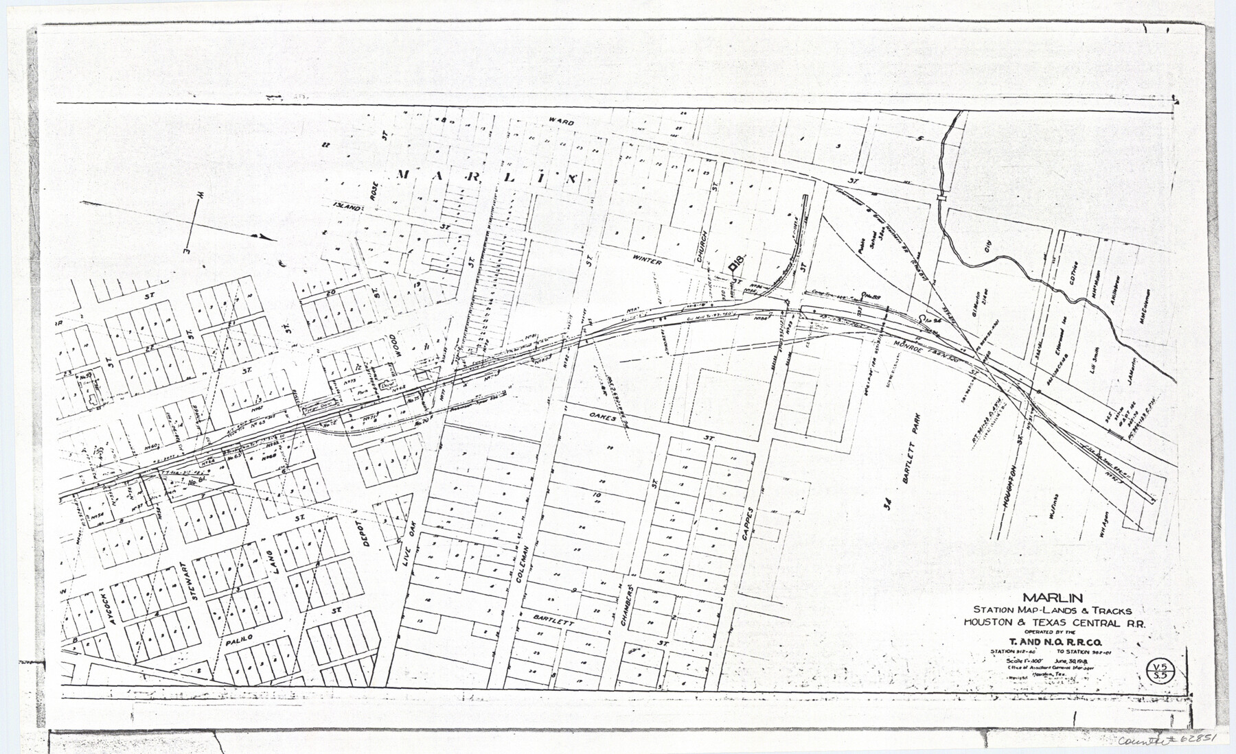
Railroad Track Map, H&TCRRCo., Falls County, Texas
Right of Way and Track Map
K-7-79 flat folder
-
Map/Doc
62851
-
Collection
General Map Collection
-
Object Dates
1918 (Creation Date)
-
Counties
Falls
-
Subjects
Railroads
-
Height x Width
11.4 x 18.7 inches
29.0 x 47.5 cm
-
Comments
Operated by the Texas and New Orleans Railroad Company, Waco Branch.
Part of: General Map Collection
Flight Mission No. CUG-2P, Frame 77, Kleberg County

Print $20.00
- Digital $50.00
Flight Mission No. CUG-2P, Frame 77, Kleberg County
1956
Size 18.6 x 22.3 inches
Map/Doc 86209
Reeves County Rolled Sketch 23

Print $20.00
- Digital $50.00
Reeves County Rolled Sketch 23
1982
Size 19.6 x 25.5 inches
Map/Doc 7491
Kleberg County Rolled Sketch 8

Print $20.00
- Digital $50.00
Kleberg County Rolled Sketch 8
1947
Size 33.0 x 42.0 inches
Map/Doc 9360
Harris County Rolled Sketch 80A

Print $40.00
- Digital $50.00
Harris County Rolled Sketch 80A
Size 42.8 x 52.6 inches
Map/Doc 9136
Flight Mission No. CLL-1N, Frame 191, Willacy County

Print $20.00
- Digital $50.00
Flight Mission No. CLL-1N, Frame 191, Willacy County
1954
Size 18.3 x 22.0 inches
Map/Doc 87061
Comanche County Working Sketch 6

Print $20.00
- Digital $50.00
Comanche County Working Sketch 6
1935
Size 26.4 x 17.8 inches
Map/Doc 68140
Flight Mission No. CRC-5R, Frame 26, Chambers County

Print $20.00
- Digital $50.00
Flight Mission No. CRC-5R, Frame 26, Chambers County
1956
Size 18.6 x 22.5 inches
Map/Doc 84948
Red River County Working Sketch 6

Print $20.00
- Digital $50.00
Red River County Working Sketch 6
1919
Size 20.1 x 20.9 inches
Map/Doc 71989
PSL Field Notes for Blocks 60, 61, 62, 83, 84, 85, 88, 89, 90, 91, 92, and 93 in Culberson County

PSL Field Notes for Blocks 60, 61, 62, 83, 84, 85, 88, 89, 90, 91, 92, and 93 in Culberson County
Map/Doc 81667
Outer Continental Shelf Leasing Maps (Louisiana Offshore Operations)

Print $20.00
- Digital $50.00
Outer Continental Shelf Leasing Maps (Louisiana Offshore Operations)
1959
Size 17.8 x 14.1 inches
Map/Doc 76095
Hockley County Sketch File 19b

Print $28.00
- Digital $50.00
Hockley County Sketch File 19b
Size 11.3 x 8.8 inches
Map/Doc 26555
Liberty County Working Sketch 9

Print $20.00
- Digital $50.00
Liberty County Working Sketch 9
Size 34.6 x 27.3 inches
Map/Doc 70468
You may also like
Photo Index of Texas Coast - Sheet 2 of 6

Print $20.00
- Digital $50.00
Photo Index of Texas Coast - Sheet 2 of 6
1954
Size 20.0 x 24.0 inches
Map/Doc 83440
Pecan Bayou Travis District

Print $20.00
- Digital $50.00
Pecan Bayou Travis District
1852
Size 25.8 x 20.5 inches
Map/Doc 4518
La Salle County Sketch File 9

Print $4.00
- Digital $50.00
La Salle County Sketch File 9
Size 6.3 x 8.3 inches
Map/Doc 29458
Castro County Rolled Sketch 8

Print $20.00
- Digital $50.00
Castro County Rolled Sketch 8
Size 34.1 x 28.8 inches
Map/Doc 5418
Cooke County Working Sketch 25

Print $20.00
- Digital $50.00
Cooke County Working Sketch 25
1974
Size 31.7 x 22.9 inches
Map/Doc 68262
Kent County Working Sketch 3a

Print $20.00
- Digital $50.00
Kent County Working Sketch 3a
1948
Size 24.5 x 18.6 inches
Map/Doc 70009
Fort Bend County Working Sketch 1

Print $20.00
- Digital $50.00
Fort Bend County Working Sketch 1
Size 16.0 x 27.4 inches
Map/Doc 69207
Amistad International Reservoir on Rio Grande 65

Print $20.00
- Digital $50.00
Amistad International Reservoir on Rio Grande 65
1949
Size 28.2 x 39.8 inches
Map/Doc 73350
Harris County Rolled Sketch 43

Print $20.00
- Digital $50.00
Harris County Rolled Sketch 43
1919
Size 15.3 x 18.9 inches
Map/Doc 6101
Gulf of Mexico

Print $20.00
- Digital $50.00
Gulf of Mexico
1900
Size 18.3 x 28.1 inches
Map/Doc 72650
Flight Mission No. DAG-26K, Frame 62, Matagorda County

Print $20.00
- Digital $50.00
Flight Mission No. DAG-26K, Frame 62, Matagorda County
1953
Size 18.7 x 22.5 inches
Map/Doc 86582
McMullen County Sketch File 30

Print $20.00
- Digital $50.00
McMullen County Sketch File 30
1884
Size 38.5 x 21.1 inches
Map/Doc 10540