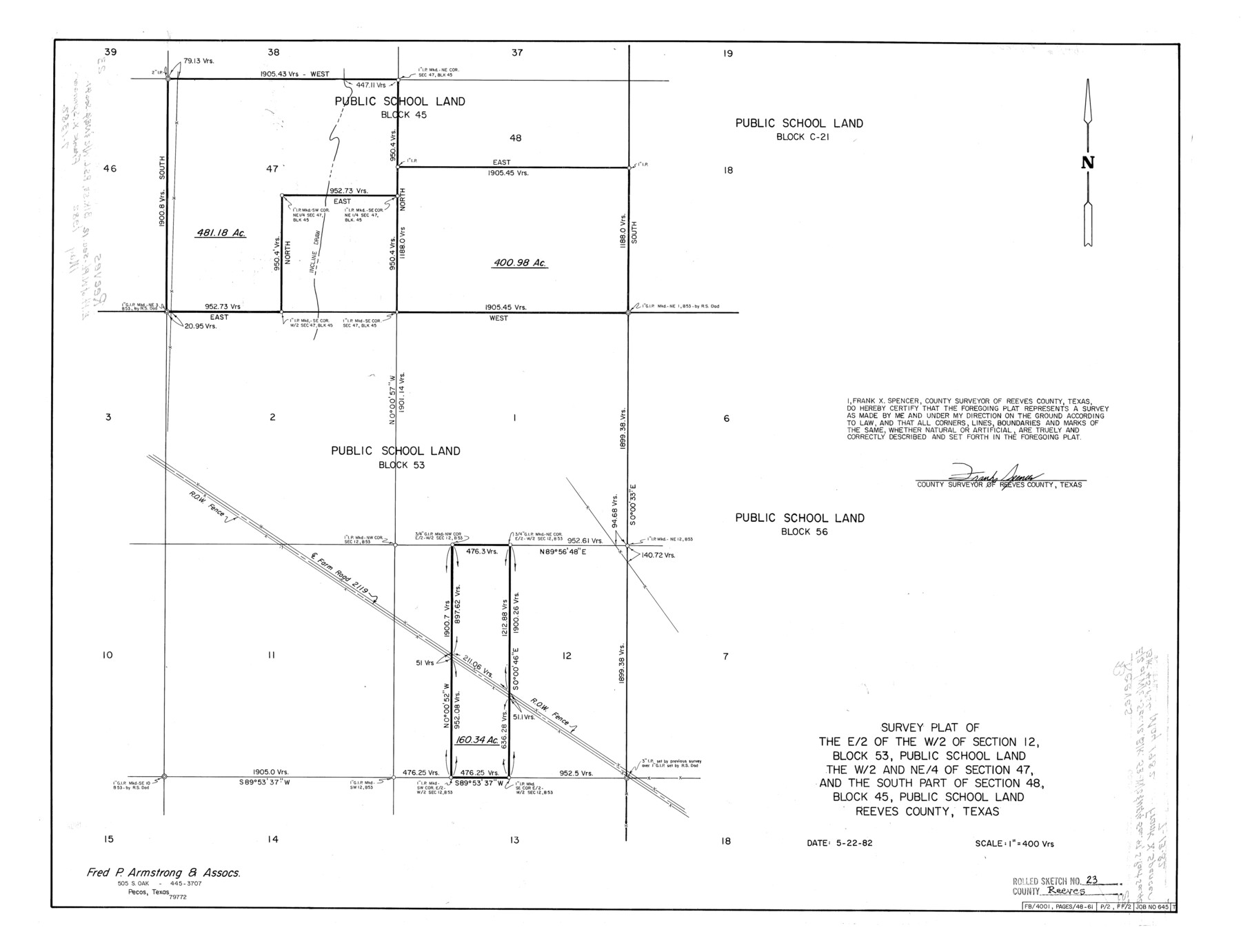
Reeves County Rolled Sketch 23
Survey plat of the E/2 of the W/2 of section 12, Block 53, Public School Land, the W/2 and NE/4 of section 47, and the south part of section 48, Block 45, Public School Land, Reeves County, Texas
-
Map/Doc
7491
-
Collection
General Map Collection
-
Object Dates
5/22/1982 (Creation Date)
7/13/1982 (File Date)
-
People and Organizations
Frank X. Spencer (Surveyor/Engineer)
-
Counties
Reeves
-
Subjects
Surveying Rolled Sketch
-
Height x Width
19.6 x 25.5 inches
49.8 x 64.8 cm
-
Scale
1" = 400 varas
Part of: General Map Collection
Galveston to Rio Grande

Print $20.00
- Digital $50.00
Galveston to Rio Grande
1939
Size 43.3 x 36.3 inches
Map/Doc 69951
Panola County Working Sketch 38

Print $20.00
- Digital $50.00
Panola County Working Sketch 38
1991
Map/Doc 71447
Tom Green County Sketch File 60

Print $20.00
- Digital $50.00
Tom Green County Sketch File 60
1888
Size 28.4 x 25.9 inches
Map/Doc 12444
Armstrong County Sketch File A-7

Print $40.00
- Digital $50.00
Armstrong County Sketch File A-7
Size 15.0 x 20.4 inches
Map/Doc 10848
'The Cradle of Texas' - San Augustine

Print $20.00
- Digital $50.00
'The Cradle of Texas' - San Augustine
Size 19.3 x 25.3 inches
Map/Doc 94441

Hudspeth County Rolled Sketch 50

Print $40.00
- Digital $50.00
Hudspeth County Rolled Sketch 50
1971
Size 56.6 x 34.8 inches
Map/Doc 9220
Flight Mission No. BRA-7M, Frame 43, Jefferson County

Print $20.00
- Digital $50.00
Flight Mission No. BRA-7M, Frame 43, Jefferson County
1953
Size 18.6 x 22.4 inches
Map/Doc 85494
![94184, Texas [Verso], General Map Collection](https://historictexasmaps.com/wmedia_w700/maps/94184.tif.jpg)
Vicinity map showing railroads serving the ports of Galveston, Houston and Texas City, Texas

Print $20.00
- Digital $50.00
Vicinity map showing railroads serving the ports of Galveston, Houston and Texas City, Texas
1924
Size 9.3 x 14.8 inches
Map/Doc 97164
Brewster County Rolled Sketch 12

Print $20.00
- Digital $50.00
Brewster County Rolled Sketch 12
1889
Size 26.7 x 31.4 inches
Map/Doc 5193
Erath County Working Sketch 17

Print $20.00
- Digital $50.00
Erath County Working Sketch 17
1962
Size 20.4 x 23.1 inches
Map/Doc 69098
You may also like

Part of City of Plains

Print $20.00
- Digital $50.00
Part of City of Plains
Size 37.1 x 23.6 inches
Map/Doc 92449
Hardin County Working Sketch 33

Print $20.00
- Digital $50.00
Hardin County Working Sketch 33
1979
Size 36.0 x 43.6 inches
Map/Doc 63431
Kimble County

Print $40.00
- Digital $50.00
Kimble County
1890
Size 40.0 x 56.9 inches
Map/Doc 66891
Map of Texas Gulf Coast and Continental Shelf showing Natural Gas Pipe Lines

Print $40.00
- Digital $50.00
Map of Texas Gulf Coast and Continental Shelf showing Natural Gas Pipe Lines
1979
Size 40.9 x 59.3 inches
Map/Doc 75905
Pecos County Rolled Sketch 54

Print $11.00
- Digital $50.00
Pecos County Rolled Sketch 54
1916
Size 9.7 x 15.0 inches
Map/Doc 48099
Flight Mission No. CLL-1N, Frame 21, Willacy County

Print $20.00
- Digital $50.00
Flight Mission No. CLL-1N, Frame 21, Willacy County
1954
Size 18.7 x 22.3 inches
Map/Doc 87008
Jasper County Sketch File 32

Print $20.00
- Digital $50.00
Jasper County Sketch File 32
1906
Size 28.0 x 22.3 inches
Map/Doc 11853
Maverick County Sketch File 24

Print $36.00
- Digital $50.00
Maverick County Sketch File 24
1890
Size 9.1 x 8.7 inches
Map/Doc 31145
Henderson County Working Sketch 15

Print $20.00
- Digital $50.00
Henderson County Working Sketch 15
1935
Size 18.3 x 18.1 inches
Map/Doc 66148

Flight Mission No. BRE-2P, Frame 63, Nueces County

Print $20.00
- Digital $50.00
Flight Mission No. BRE-2P, Frame 63, Nueces County
1956
Size 18.5 x 22.5 inches
Map/Doc 86758