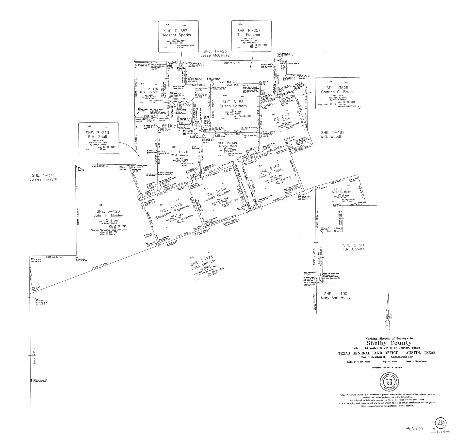
Shelby County Working Sketch 28
-
Map/Doc
63882
-
Collection
General Map Collection
-
Object Dates
7/20/2000 (Creation Date)
-
People and Organizations
Mark Neugebauer (Draftsman)
-
Counties
Shelby
-
Subjects
Surveying Working Sketch
-
Height x Width
28.8 x 29.8 inches
73.2 x 75.7 cm
-
Scale
1" = 300 varas
Part of: General Map Collection
Gregg County Rolled Sketch 17

Print $20.00
- Digital $50.00
Gregg County Rolled Sketch 17
1933
Size 14.0 x 27.9 inches
Map/Doc 6040
Flight Mission No. DCL-7C, Frame 25, Kenedy County

Print $20.00
- Digital $50.00
Flight Mission No. DCL-7C, Frame 25, Kenedy County
1943
Size 15.4 x 15.4 inches
Map/Doc 86017
Tom Green County Sketch File 50

Print $20.00
- Digital $50.00
Tom Green County Sketch File 50
1884
Size 25.4 x 34.5 inches
Map/Doc 12442
Roberts County Rolled Sketch 4

Print $52.00
- Digital $50.00
Roberts County Rolled Sketch 4
2006
Size 66.9 x 20.0 inches
Map/Doc 83620
Jefferson County Working Sketch 33

Print $20.00
- Digital $50.00
Jefferson County Working Sketch 33
1981
Size 18.8 x 15.4 inches
Map/Doc 66577
Brazoria County Sketch File 21

Print $4.00
- Digital $50.00
Brazoria County Sketch File 21
Size 8.3 x 7.5 inches
Map/Doc 15016
McCulloch County

Print $20.00
- Digital $50.00
McCulloch County
1895
Size 23.3 x 18.7 inches
Map/Doc 3854
Cass County Rolled Sketch 7

Print $20.00
- Digital $50.00
Cass County Rolled Sketch 7
1957
Size 28.3 x 33.5 inches
Map/Doc 5413
Baie de Galvez-Town

Print $20.00
- Digital $50.00
Baie de Galvez-Town
1820
Size 10.3 x 12.9 inches
Map/Doc 95832
[Sketch of Oyster Bay, Bastrop Bay, Chocolate Bay, and West Bay]
![3103, [Sketch of Oyster Bay, Bastrop Bay, Chocolate Bay, and West Bay], General Map Collection](https://historictexasmaps.com/wmedia_w700/maps/3103.tif.jpg)
Print $20.00
- Digital $50.00
[Sketch of Oyster Bay, Bastrop Bay, Chocolate Bay, and West Bay]
1871
Size 6.0 x 23.9 inches
Map/Doc 3103
Lipscomb County Boundary File 9

Print $8.00
- Digital $50.00
Lipscomb County Boundary File 9
Size 11.2 x 8.5 inches
Map/Doc 56335
Concho County Sketch File 28

Print $6.00
- Digital $50.00
Concho County Sketch File 28
1887
Size 16.2 x 8.3 inches
Map/Doc 19166
You may also like
Current Miscellaneous File 21

Print $26.00
- Digital $50.00
Current Miscellaneous File 21
1952
Size 10.8 x 8.2 inches
Map/Doc 73865
[Rio Grande & Eagle Pass - Stockdale to Cuero]
![64047, [Rio Grande & Eagle Pass - Stockdale to Cuero], General Map Collection](https://historictexasmaps.com/wmedia_w700/maps/64047.tif.jpg)
Print $40.00
- Digital $50.00
[Rio Grande & Eagle Pass - Stockdale to Cuero]
Size 20.6 x 121.5 inches
Map/Doc 64047
Irion County Working Sketch 2

Print $20.00
- Digital $50.00
Irion County Working Sketch 2
1921
Size 34.2 x 20.6 inches
Map/Doc 66411
[Located Line of the Panhandle & Gulf Ry. through State Lands]
![64103, [Located Line of the Panhandle & Gulf Ry. through State Lands], General Map Collection](https://historictexasmaps.com/wmedia_w700/maps/64103.tif.jpg)
Print $40.00
- Digital $50.00
[Located Line of the Panhandle & Gulf Ry. through State Lands]
1904
Size 12.4 x 121.6 inches
Map/Doc 64103
Titus County, Texas

Print $20.00
- Digital $50.00
Titus County, Texas
1880
Size 29.4 x 22.8 inches
Map/Doc 629
Map of Dallas County Showing Location of Texas and Pacific Railway

Print $20.00
- Digital $50.00
Map of Dallas County Showing Location of Texas and Pacific Railway
1872
Size 25.2 x 21.4 inches
Map/Doc 64134
The United States of Mexico

Print $20.00
- Digital $50.00
The United States of Mexico
1832
Size 15.4 x 12.8 inches
Map/Doc 93952


Kent County Working Sketch 11

Print $20.00
- Digital $50.00
Kent County Working Sketch 11
Size 24.3 x 37.4 inches
Map/Doc 70018
Flight Mission No. DQO-2K, Frame 151, Galveston County

Print $20.00
- Digital $50.00
Flight Mission No. DQO-2K, Frame 151, Galveston County
1952
Size 18.9 x 22.6 inches
Map/Doc 85048
Dimmit County Working Sketch 58

Print $20.00
- Digital $50.00
Dimmit County Working Sketch 58
2017
Size 24.2 x 36.2 inches
Map/Doc 94121