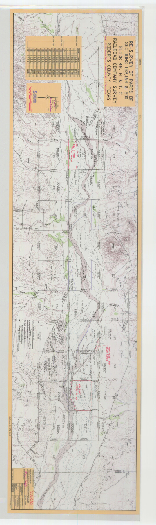
Roberts County Rolled Sketch 4
Re-survey of parts of sections 152, 164, & 200, Block 42, H. & T. C. Railroad Company survey, Roberts County, Texas [and report]
-
Map/Doc
83620
-
Collection
General Map Collection
-
Object Dates
2006/1/23 (Creation Date)
2006/3/16 (File Date)
-
People and Organizations
Maxey Sheppard (Surveyor/Engineer)
-
Counties
Roberts
-
Subjects
Surveying Rolled Sketch
-
Height x Width
66.9 x 20.0 inches
169.9 x 50.8 cm
-
Medium
mylar, print
-
Scale
1" = 500 varas
Part of: General Map Collection
Flight Mission No. BRE-1P, Frame 93, Nueces County

Print $20.00
- Digital $50.00
Flight Mission No. BRE-1P, Frame 93, Nueces County
1956
Size 18.5 x 22.2 inches
Map/Doc 86664

Smith County Rolled Sketch 7

Print $20.00
- Digital $50.00
Smith County Rolled Sketch 7
2003
Size 46.4 x 35.3 inches
Map/Doc 80141
Map of Galveston, Turtle & East Bays & portions of the Gulf of Mexico in Chambers & Galveston Counties, Texas showing subdivision for mineral development

Print $40.00
- Digital $50.00
Map of Galveston, Turtle & East Bays & portions of the Gulf of Mexico in Chambers & Galveston Counties, Texas showing subdivision for mineral development
Size 48.6 x 56.4 inches
Map/Doc 65803
Brewster County Rolled Sketch 76

Print $20.00
- Digital $50.00
Brewster County Rolled Sketch 76
Size 17.3 x 19.0 inches
Map/Doc 5241
Liberty County Sketch File 20

Print $6.00
- Digital $50.00
Liberty County Sketch File 20
Size 7.8 x 9.9 inches
Map/Doc 29925
Jefferson County Working Sketch 36

Print $40.00
- Digital $50.00
Jefferson County Working Sketch 36
1982
Size 69.1 x 33.2 inches
Map/Doc 66580
Flight Mission No. DQN-1K, Frame 47, Calhoun County

Print $20.00
- Digital $50.00
Flight Mission No. DQN-1K, Frame 47, Calhoun County
1953
Size 18.4 x 22.6 inches
Map/Doc 84147
Maverick County Rolled Sketch 19

Print $20.00
- Digital $50.00
Maverick County Rolled Sketch 19
1955
Size 33.5 x 44.1 inches
Map/Doc 9494
Coryell County

Print $20.00
- Digital $50.00
Coryell County
1936
Size 44.6 x 40.1 inches
Map/Doc 77249
Webb County Rolled Sketch 78A

Print $20.00
- Digital $50.00
Webb County Rolled Sketch 78A
Size 28.4 x 23.0 inches
Map/Doc 90053
Kleberg County Boundary File 2a

Print $40.00
- Digital $50.00
Kleberg County Boundary File 2a
Size 15.4 x 58.3 inches
Map/Doc 64977
You may also like
Presidio County Sketch File 88 1/2

Print $4.00
- Digital $50.00
Presidio County Sketch File 88 1/2
Size 14.4 x 8.8 inches
Map/Doc 34754
Cameron County Rolled Sketch 11A

Print $20.00
- Digital $50.00
Cameron County Rolled Sketch 11A
1934
Size 30.0 x 37.0 inches
Map/Doc 11048
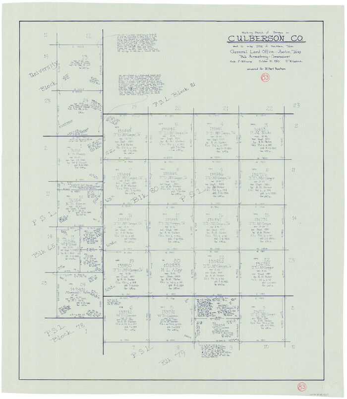
Culberson County Working Sketch 83
Print $20.00
- Digital $50.00
Culberson County Working Sketch 83
1980
Size 33.4 x 28.9 inches
Map/Doc 68537
Hansford County, Texas

Print $20.00
- Digital $50.00
Hansford County, Texas
1888
Size 22.6 x 18.6 inches
Map/Doc 5033
Traced from Genl. Arista's map captured by the American Army under Genl. Taylor at Resaca de la Palma 9th May '46 and presented to James K. Polk, President U. States

Print $20.00
- Digital $50.00
Traced from Genl. Arista's map captured by the American Army under Genl. Taylor at Resaca de la Palma 9th May '46 and presented to James K. Polk, President U. States
1846
Size 18.2 x 27.4 inches
Map/Doc 73061
Old Miscellaneous File 33

Print $4.00
- Digital $50.00
Old Miscellaneous File 33
1874
Size 9.8 x 8.1 inches
Map/Doc 75753
Blanco County Rolled Sketch 21

Print $20.00
- Digital $50.00
Blanco County Rolled Sketch 21
2007
Size 18.1 x 13.0 inches
Map/Doc 87925
![94159, Austin Street Map [Verso], General Map Collection](https://historictexasmaps.com/wmedia_w700/maps/94159.tif.jpg)
Robertson County Working Sketch 4

Print $20.00
- Digital $50.00
Robertson County Working Sketch 4
1979
Size 19.5 x 32.1 inches
Map/Doc 63577
Leon County Working Sketch 9

Print $20.00
- Digital $50.00
Leon County Working Sketch 9
1949
Size 16.7 x 18.1 inches
Map/Doc 70408
Harris County NRC Article 33.136 Location Key Sheet

Print $20.00
- Digital $50.00
Harris County NRC Article 33.136 Location Key Sheet
1982
Size 27.0 x 22.5 inches
Map/Doc 77026
Mitchell's Travellers Guide Through the United States. A Map of the Roads, Distances, Steam Boat, and Canal Routes etc.

Print $20.00
Mitchell's Travellers Guide Through the United States. A Map of the Roads, Distances, Steam Boat, and Canal Routes etc.
1835
Size 18.0 x 22.7 inches
Map/Doc 79723