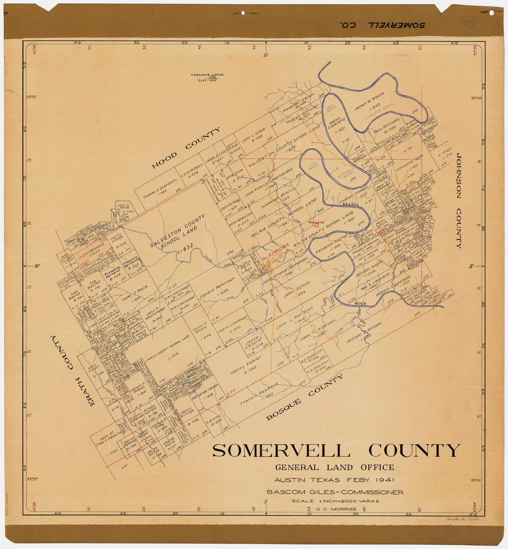
Somervell County
-
Map/Doc
73291
-
Collection
General Map Collection
-
Object Dates
1941 (Creation Date)
-
People and Organizations
Texas General Land Office (Publisher)
Bascom Giles (GLO Commissioner)
G.C. Morriss (Draftsman)
-
Counties
Somervell
-
Subjects
County
-
Height x Width
28.1 x 26.1 inches
71.4 x 66.3 cm
-
Comments
Hand lettered.
Note on reverse side: "Replaced [on sticks] by copy June 20, 1946." -
Features
Nemo
Abby Bend of Brazos River
Bosque River
Hill Creek
Lick Creek
Briar Creek
Cross Branch of Paluxy Creek
Montgomery Branch [of Squaw Creek]
Rock Creek
Buck Creek
Glenrose
Comanche Peak
Rainbow
Van Zandt Branch [of Squaw Creek]
Wheeler Branch [of Squaw Creek]
Paluxy Creek
Brazos River
Mitchell Bend of Brazos River
Squaw Creek
Cox Bend of Brazos River
Cordova Bend of Brazos River
Part of: General Map Collection
Angelina County Working Sketch 19

Print $20.00
- Digital $50.00
Angelina County Working Sketch 19
1946
Size 35.8 x 39.3 inches
Map/Doc 67100
Flight Mission No. CUG-2P, Frame 25, Kleberg County

Print $20.00
- Digital $50.00
Flight Mission No. CUG-2P, Frame 25, Kleberg County
1956
Size 18.5 x 22.2 inches
Map/Doc 86189
Potter County Rolled Sketch 11

Print $20.00
- Digital $50.00
Potter County Rolled Sketch 11
1986
Size 21.6 x 27.4 inches
Map/Doc 7324
Nueces County Rolled Sketch 75

Print $40.00
- Digital $50.00
Nueces County Rolled Sketch 75
1945
Size 56.0 x 24.0 inches
Map/Doc 9618
Roberts County Working Sketch 11

Print $40.00
- Digital $50.00
Roberts County Working Sketch 11
1966
Size 57.6 x 38.6 inches
Map/Doc 63537
Burleson County Working Sketch 15

Print $20.00
- Digital $50.00
Burleson County Working Sketch 15
1980
Size 15.0 x 21.1 inches
Map/Doc 67734
Marion County Rolled Sketch 8

Print $20.00
- Digital $50.00
Marion County Rolled Sketch 8
1998
Size 33.0 x 22.1 inches
Map/Doc 6661
Uvalde County

Print $20.00
- Digital $50.00
Uvalde County
1915
Size 42.9 x 46.2 inches
Map/Doc 63091
Right of Way and Track Map, International & Gt. Northern Ry. operated by the International & Gt. Northern Ry. Co. Gulf Division, Mineola Branch

Print $40.00
- Digital $50.00
Right of Way and Track Map, International & Gt. Northern Ry. operated by the International & Gt. Northern Ry. Co. Gulf Division, Mineola Branch
1917
Size 26.3 x 125.4 inches
Map/Doc 64700
Taylor County Rolled Sketch 28

Print $20.00
- Digital $50.00
Taylor County Rolled Sketch 28
Size 34.4 x 23.9 inches
Map/Doc 7921
Mexico, Texas und Californien

Print $20.00
- Digital $50.00
Mexico, Texas und Californien
1855
Size 22.7 x 28.0 inches
Map/Doc 93651
Galveston County Rolled Sketch 29

Print $104.00
- Digital $50.00
Galveston County Rolled Sketch 29
Size 10.1 x 15.3 inches
Map/Doc 45147
You may also like
Childress County Sketch File 24

Print $4.00
- Digital $50.00
Childress County Sketch File 24
1917
Size 12.9 x 8.6 inches
Map/Doc 18384
Haskell County Sketch File 1A

Print $40.00
- Digital $50.00
Haskell County Sketch File 1A
Size 12.3 x 14.5 inches
Map/Doc 26119
Flight Mission No. CLL-1N, Frame 102, Willacy County

Print $20.00
- Digital $50.00
Flight Mission No. CLL-1N, Frame 102, Willacy County
1954
Size 18.3 x 22.0 inches
Map/Doc 87036
J. De Cordova's Map of the State of Texas Compiled from the records of the General Land Office of the State

Print $20.00
J. De Cordova's Map of the State of Texas Compiled from the records of the General Land Office of the State
1856
Size 34.2 x 32.1 inches
Map/Doc 76222
Map of Nolan County, Texas

Print $20.00
Map of Nolan County, Texas
1890
Size 24.4 x 19.3 inches
Map/Doc 88984
Presidio County Rolled Sketch 146

Print $20.00
- Digital $50.00
Presidio County Rolled Sketch 146
2018
Size 29.8 x 41.8 inches
Map/Doc 95821
Map of San Augustine County

Print $20.00
- Digital $50.00
Map of San Augustine County
1839
Size 22.3 x 18.2 inches
Map/Doc 4011
Atascosa County Sketch File 42

Print $12.00
- Digital $50.00
Atascosa County Sketch File 42
1916
Size 11.2 x 8.8 inches
Map/Doc 13847
Red River County Working Sketch 79

Print $40.00
- Digital $50.00
Red River County Working Sketch 79
1986
Size 43.8 x 61.1 inches
Map/Doc 72062
Kinney County Rolled Sketch 11

Print $20.00
- Digital $50.00
Kinney County Rolled Sketch 11
1944
Size 39.2 x 32.0 inches
Map/Doc 6540
Harris County Working Sketch 114

Print $20.00
- Digital $50.00
Harris County Working Sketch 114
1983
Size 37.6 x 29.0 inches
Map/Doc 66006
Flight Mission No. DAG-17K, Frame 63, Matagorda County

Print $20.00
- Digital $50.00
Flight Mission No. DAG-17K, Frame 63, Matagorda County
1952
Size 18.6 x 22.3 inches
Map/Doc 86325