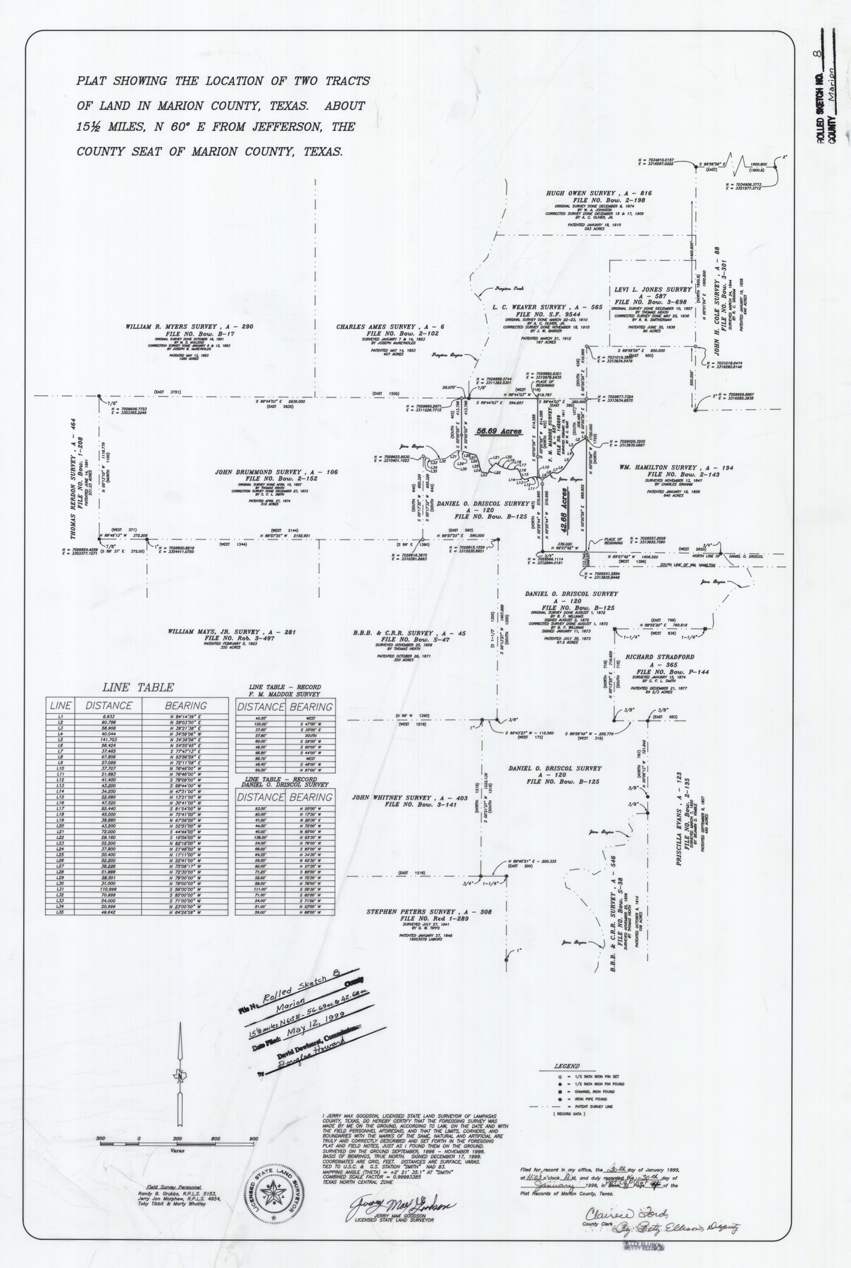
Marion County Rolled Sketch 8
Plat showing the location of two tracts of land in Marion County, Texas
-
Map/Doc
6661
-
Collection
General Map Collection
-
Object Dates
1998 (Survey Date)
1999/5/12 (File Date)
1998/12/17 (Creation Date)
-
People and Organizations
Jerry Max Goodson (Surveyor/Engineer)
Randy B. Grubbs (Chainman/Field Personnel)
Jerry Jon Morphew (Chainman/Field Personnel)
Toby Tibbit (Chainman/Field Personnel)
Marty Whatley (Chainman/Field Personnel)
-
Counties
Marion
-
Subjects
Surveying Rolled Sketch
-
Height x Width
33.0 x 22.1 inches
83.8 x 56.1 cm
-
Medium
mylar, print
Part of: General Map Collection
Map of Polk County

Print $20.00
- Digital $50.00
Map of Polk County
1856
Size 22.1 x 23.7 inches
Map/Doc 3961

Dawson County Sketch File A

Print $28.00
- Digital $50.00
Dawson County Sketch File A
1903
Size 11.4 x 8.8 inches
Map/Doc 20461
Taylor County Rolled Sketch 19

Print $20.00
- Digital $50.00
Taylor County Rolled Sketch 19
1886
Size 23.5 x 30.8 inches
Map/Doc 7913
Dallas County Boundary File 6a

Print $36.00
- Digital $50.00
Dallas County Boundary File 6a
Size 14.0 x 8.6 inches
Map/Doc 52189
Sterling County Sketch File 20

Print $12.00
- Digital $50.00
Sterling County Sketch File 20
1952
Size 11.2 x 8.7 inches
Map/Doc 37173
Edwards County Working Sketch 46

Print $20.00
- Digital $50.00
Edwards County Working Sketch 46
1950
Size 39.8 x 37.4 inches
Map/Doc 68922
Burleson County Working Sketch 36

Print $20.00
- Digital $50.00
Burleson County Working Sketch 36
1982
Size 31.0 x 33.3 inches
Map/Doc 67755
Flight Mission No. BRE-1P, Frame 68, Nueces County

Print $20.00
- Digital $50.00
Flight Mission No. BRE-1P, Frame 68, Nueces County
1956
Size 17.7 x 21.8 inches
Map/Doc 86650
Callahan County Working Sketch 6

Print $20.00
- Digital $50.00
Callahan County Working Sketch 6
1955
Size 30.2 x 18.8 inches
Map/Doc 67888
Moore County Working Sketch 1

Print $20.00
- Digital $50.00
Moore County Working Sketch 1
1909
Size 32.0 x 32.4 inches
Map/Doc 71183
Lampasas County Working Sketch 14

Print $20.00
- Digital $50.00
Lampasas County Working Sketch 14
1974
Size 23.4 x 21.8 inches
Map/Doc 70291
You may also like
Zapata County Rolled Sketch 7A

Print $20.00
- Digital $50.00
Zapata County Rolled Sketch 7A
1912
Size 17.9 x 26.6 inches
Map/Doc 8309
Upton County Rolled Sketch 23

Print $20.00
- Digital $50.00
Upton County Rolled Sketch 23
1940
Size 25.7 x 39.4 inches
Map/Doc 8074
Travis County Sketch File 50

Print $20.00
- Digital $50.00
Travis County Sketch File 50
1871
Size 18.7 x 23.5 inches
Map/Doc 12469
Wavel's [Wavell's] Register of Families
![94252, Wavel's [Wavell's] Register of Families, Historical Volumes](https://historictexasmaps.com/wmedia_w700/pdf_converted_jpg/qi_pdf_thumbnail_38893.jpg)
Wavel's [Wavell's] Register of Families
Size 13.2 x 9.2 inches
Map/Doc 94252
Live Oak County Working Sketch 12

Print $20.00
- Digital $50.00
Live Oak County Working Sketch 12
1949
Size 23.1 x 19.7 inches
Map/Doc 70597
Kaufman County Working Sketch 7

Print $20.00
- Digital $50.00
Kaufman County Working Sketch 7
1984
Size 33.6 x 35.5 inches
Map/Doc 66670
Liberty County Sketch File 21

Print $5.00
- Digital $50.00
Liberty County Sketch File 21
1858
Size 7.9 x 13.0 inches
Map/Doc 29928
San Patricio County NRC Article 33.136 Location Key Sheet

Print $20.00
- Digital $50.00
San Patricio County NRC Article 33.136 Location Key Sheet
1975
Size 27.0 x 23.0 inches
Map/Doc 77036
Bee County Sketch File 6

Print $6.00
- Digital $50.00
Bee County Sketch File 6
1860
Size 12.3 x 7.7 inches
Map/Doc 14272
Marion County Working Sketch 2

Print $20.00
- Digital $50.00
Marion County Working Sketch 2
Size 37.5 x 28.2 inches
Map/Doc 70777
Harris County Sketch File 101

Print $104.00
- Digital $50.00
Harris County Sketch File 101
1991
Size 11.3 x 8.9 inches
Map/Doc 25873
Flight Mission No. DQN-7K, Frame 11, Calhoun County

Print $20.00
- Digital $50.00
Flight Mission No. DQN-7K, Frame 11, Calhoun County
1953
Size 18.6 x 22.3 inches
Map/Doc 84462