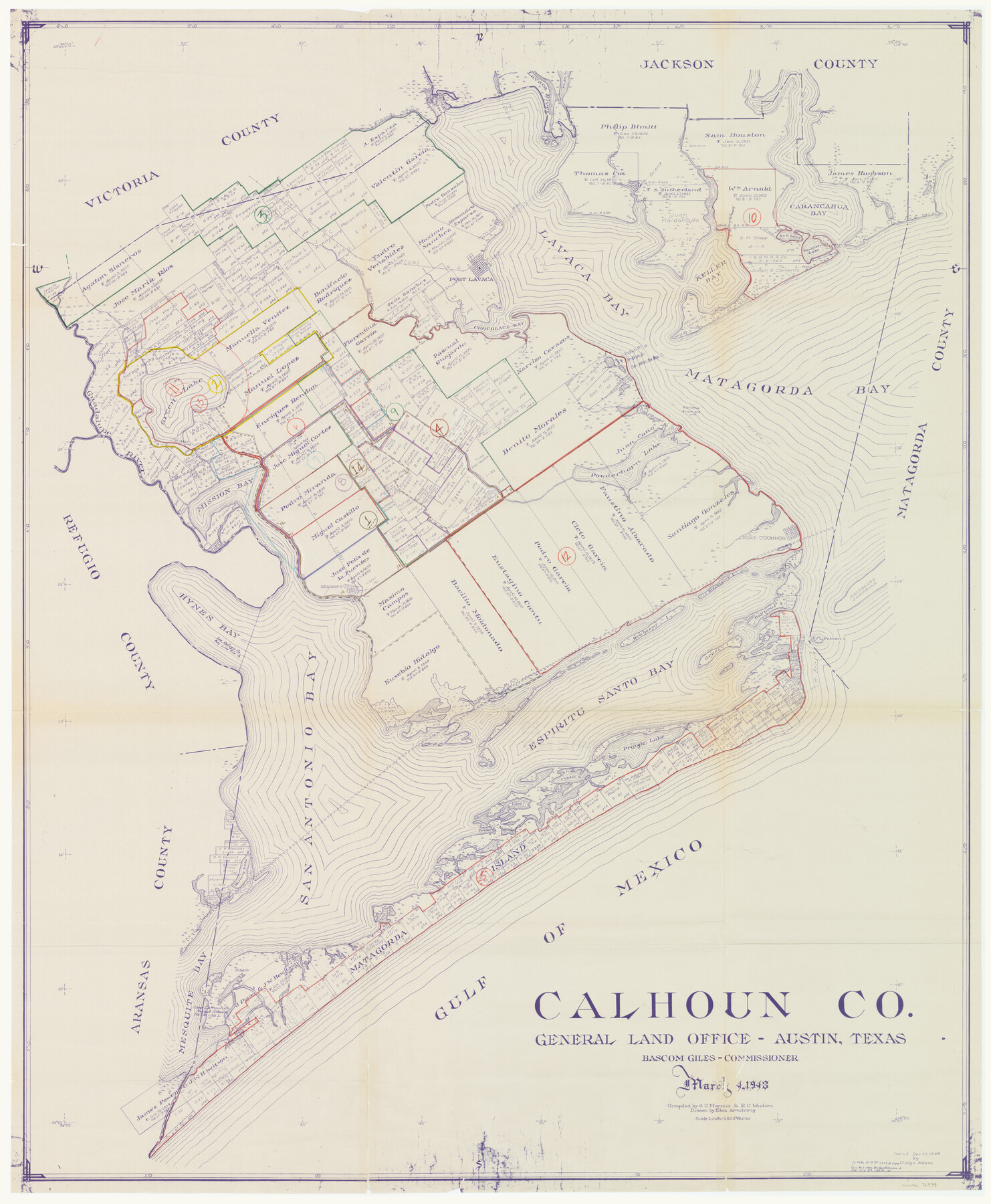
Calhoun County Working Sketch Graphic Index
-
Map/Doc
76484
-
Collection
General Map Collection
-
Object Dates
3/4/1948 (Creation Date)
-
People and Organizations
G.C. Morriss (Compiler)
R.C. Wisdom (Compiler)
Eltea Armstrong (Draftsman)
-
Counties
Calhoun
-
Subjects
County Surveying Working Sketch
-
Height x Width
48.2 x 40.1 inches
122.4 x 101.9 cm
-
Scale
1" = 2000 varas
Part of: General Map Collection
Flight Mission No. BRE-2P, Frame 19, Nueces County

Print $20.00
- Digital $50.00
Flight Mission No. BRE-2P, Frame 19, Nueces County
1956
Size 18.4 x 22.2 inches
Map/Doc 86728
Bee County Sketch File 16

Print $4.00
- Digital $50.00
Bee County Sketch File 16
1878
Size 8.6 x 7.7 inches
Map/Doc 14299
Smith County Sketch File 14

Print $4.00
- Digital $50.00
Smith County Sketch File 14
1888
Size 12.3 x 8.8 inches
Map/Doc 36775

Jackson County Rolled Sketch 2

Print $20.00
- Digital $50.00
Jackson County Rolled Sketch 2
Size 14.1 x 17.9 inches
Map/Doc 6335
Current Miscellaneous File 53

Print $8.00
- Digital $50.00
Current Miscellaneous File 53
1945
Size 12.0 x 9.1 inches
Map/Doc 74038
Flight Mission No. DQO-1K, Frame 148, Galveston County

Print $20.00
- Digital $50.00
Flight Mission No. DQO-1K, Frame 148, Galveston County
1952
Size 18.8 x 22.5 inches
Map/Doc 85001
Upton County Working Sketch 22

Print $40.00
- Digital $50.00
Upton County Working Sketch 22
1951
Size 37.5 x 48.7 inches
Map/Doc 69518
Lynn County Boundary File 10

Print $110.00
- Digital $50.00
Lynn County Boundary File 10
Size 14.3 x 8.7 inches
Map/Doc 56709
San Patricio County Sketch File 36

Print $26.00
- Digital $50.00
San Patricio County Sketch File 36
1940
Size 11.3 x 8.7 inches
Map/Doc 36129
Young County Rolled Sketch 11

Print $20.00
- Digital $50.00
Young County Rolled Sketch 11
Size 14.9 x 23.1 inches
Map/Doc 8299
Brewster County Rolled Sketch 29

Print $20.00
- Digital $50.00
Brewster County Rolled Sketch 29
1910
Size 17.5 x 18.5 inches
Map/Doc 5216
You may also like

Translation of Titles - Austin's First Colony, Vol. 2

Translation of Titles - Austin's First Colony, Vol. 2
1841
Map/Doc 94545
Reeves County Rolled Sketch 4

Print $20.00
- Digital $50.00
Reeves County Rolled Sketch 4
1891
Size 23.9 x 39.6 inches
Map/Doc 7476
Eastland County Working Sketch 44

Print $20.00
- Digital $50.00
Eastland County Working Sketch 44
1979
Size 28.8 x 23.5 inches
Map/Doc 68825
Presidio County Working Sketch 60

Print $20.00
- Digital $50.00
Presidio County Working Sketch 60
1957
Size 21.9 x 18.4 inches
Map/Doc 71737
Williamson County Sketch File 21

Print $4.00
- Digital $50.00
Williamson County Sketch File 21
1893
Size 11.3 x 8.7 inches
Map/Doc 40350
Right of Way and Track Map of The Wichita Falls & Southern Railroad Company

Print $40.00
- Digital $50.00
Right of Way and Track Map of The Wichita Falls & Southern Railroad Company
1942
Size 24.6 x 56.1 inches
Map/Doc 64519

Report Upon the Resurvey and Location of the Boundary Line between the States of Texas and New Mexico

Print $1706.00
Report Upon the Resurvey and Location of the Boundary Line between the States of Texas and New Mexico
1911
Map/Doc 81686
[Sketch of Railroad Switchyard stretching from Ross to Monroe Streets, Amarillo, Texas]
![91830, [Sketch of Railroad Switchyard stretching from Ross to Monroe Streets, Amarillo, Texas], Twichell Survey Records](https://historictexasmaps.com/wmedia_w700/maps/91830-1.tif.jpg)
Print $20.00
- Digital $50.00
[Sketch of Railroad Switchyard stretching from Ross to Monroe Streets, Amarillo, Texas]
Size 10.0 x 36.1 inches
Map/Doc 91830
Chambers County NRC Article 33.136 Sketch 10

Print $44.00
- Digital $50.00
Chambers County NRC Article 33.136 Sketch 10
2014
Size 24.0 x 36.0 inches
Map/Doc 94498
Edwards County Working Sketch 79

Print $40.00
- Digital $50.00
Edwards County Working Sketch 79
1962
Size 58.5 x 26.6 inches
Map/Doc 68955