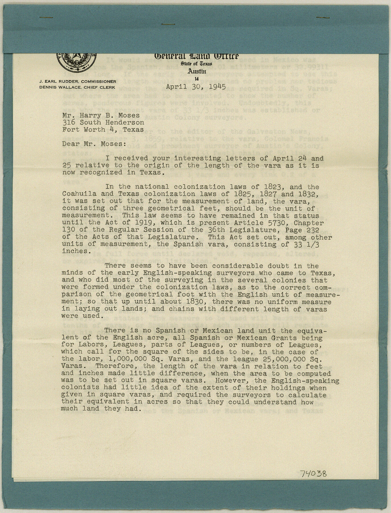
Current Miscellaneous File 53
Letter to Harry B. Moses relating to the origins of the Texas Vara
-
Map/Doc
74038
-
Collection
General Map Collection
-
Object Dates
1945/4/30 (Creation Date)
1955/8/1 (File Date)
-
Subjects
Curiosities
-
Height x Width
12.0 x 9.1 inches
30.5 x 23.1 cm
Part of: General Map Collection
Flight Mission No. DQN-2K, Frame 8, Calhoun County

Print $20.00
- Digital $50.00
Flight Mission No. DQN-2K, Frame 8, Calhoun County
1953
Size 15.8 x 15.6 inches
Map/Doc 84225
Aransas County Sketch File B

Print $4.00
- Digital $50.00
Aransas County Sketch File B
Size 6.9 x 11.4 inches
Map/Doc 13216
Hudspeth County Working Sketch 37

Print $20.00
- Digital $50.00
Hudspeth County Working Sketch 37
1978
Size 32.8 x 46.8 inches
Map/Doc 66322
[Sketch for Mineral Application 19560 - 19588 - San Bernard River]
![65660, [Sketch for Mineral Application 19560 - 19588 - San Bernard River], General Map Collection](https://historictexasmaps.com/wmedia_w700/maps/65660.tif.jpg)
Print $40.00
- Digital $50.00
[Sketch for Mineral Application 19560 - 19588 - San Bernard River]
Size 98.0 x 33.0 inches
Map/Doc 65660
Andrews County Rolled Sketch 26

Print $40.00
- Digital $50.00
Andrews County Rolled Sketch 26
1948
Size 78.3 x 13.2 inches
Map/Doc 8398
[Plat of Texas and Pacific Railroad Company Block Lines, 80 Mile Reserve]
![3124, [Plat of Texas and Pacific Railroad Company Block Lines, 80 Mile Reserve], General Map Collection](https://historictexasmaps.com/wmedia_w700/maps/3124-1.tif.jpg)
Print $40.00
- Digital $50.00
[Plat of Texas and Pacific Railroad Company Block Lines, 80 Mile Reserve]
1876
Size 43.5 x 46.3 inches
Map/Doc 3124
Corpus Christi Bay

Print $20.00
- Digital $50.00
Corpus Christi Bay
1975
Size 36.1 x 47.5 inches
Map/Doc 73475
Nolan County Boundary File 2

Print $52.00
- Digital $50.00
Nolan County Boundary File 2
Size 8.7 x 8.1 inches
Map/Doc 57649
Knox County Rolled Sketch 26

Print $20.00
- Digital $50.00
Knox County Rolled Sketch 26
2007
Size 36.8 x 24.7 inches
Map/Doc 88822
Map of Wichita County Young Land District, formerly Fannin Land District

Print $20.00
- Digital $50.00
Map of Wichita County Young Land District, formerly Fannin Land District
1859
Size 22.4 x 20.5 inches
Map/Doc 4141
Culberson County Rolled Sketch 51

Print $20.00
- Digital $50.00
Culberson County Rolled Sketch 51
1966
Size 35.2 x 27.0 inches
Map/Doc 5670
Dimmit County Boundary File 10a

Print $4.00
- Digital $50.00
Dimmit County Boundary File 10a
Size 14.0 x 8.5 inches
Map/Doc 52611
You may also like
Flight Mission No. DQO-8K, Frame 74, Galveston County

Print $20.00
- Digital $50.00
Flight Mission No. DQO-8K, Frame 74, Galveston County
1952
Size 18.7 x 22.4 inches
Map/Doc 85178
Duval County Rolled Sketch 44

Print $40.00
- Digital $50.00
Duval County Rolled Sketch 44
1981
Size 36.5 x 90.5 inches
Map/Doc 8821
Runnels County Sketch File 31

Print $6.00
Runnels County Sketch File 31
1950
Size 11.5 x 8.8 inches
Map/Doc 35496
Clay County Sketch File 14

Print $40.00
- Digital $50.00
Clay County Sketch File 14
1873
Size 16.5 x 13.8 inches
Map/Doc 18417
[H. & T. C. RR. Company, Block 47 and vicinity]
![91158, [H. & T. C. RR. Company, Block 47 and vicinity], Twichell Survey Records](https://historictexasmaps.com/wmedia_w700/maps/91158-1.tif.jpg)
Print $20.00
- Digital $50.00
[H. & T. C. RR. Company, Block 47 and vicinity]
Size 18.5 x 19.2 inches
Map/Doc 91158
Scrivener's North-west Sub-division, Wichita County, Texas

Print $20.00
- Digital $50.00
Scrivener's North-west Sub-division, Wichita County, Texas
Size 20.0 x 26.0 inches
Map/Doc 91994
El Paso County Boundary File 22

Print $4.00
- Digital $50.00
El Paso County Boundary File 22
Size 13.6 x 8.6 inches
Map/Doc 53216
Presidio County Sketch File 37

Print $16.00
- Digital $50.00
Presidio County Sketch File 37
Size 14.3 x 8.7 inches
Map/Doc 34491
Working Sketch in Gaines and Dawson Counties

Print $20.00
- Digital $50.00
Working Sketch in Gaines and Dawson Counties
1939
Size 43.4 x 45.3 inches
Map/Doc 93254
Garza County Rolled Sketch 6C

Print $20.00
- Digital $50.00
Garza County Rolled Sketch 6C
Size 24.7 x 19.2 inches
Map/Doc 5997
Tarrant County Working Sketch 17

Print $20.00
- Digital $50.00
Tarrant County Working Sketch 17
1983
Size 24.6 x 20.7 inches
Map/Doc 62434
Tyler County Working Sketch 23

Print $20.00
- Digital $50.00
Tyler County Working Sketch 23
1988
Size 28.2 x 22.8 inches
Map/Doc 69493