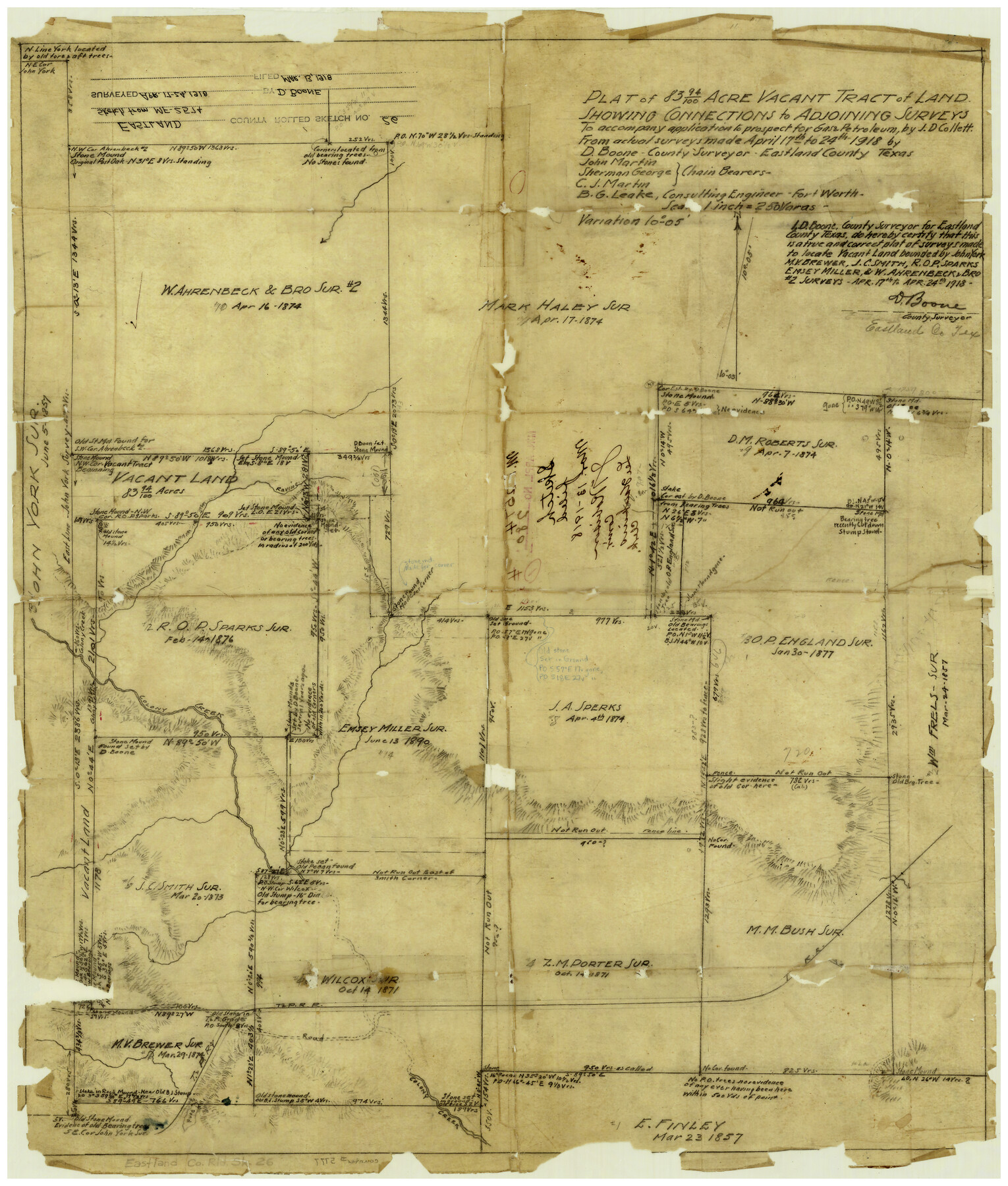
Eastland County Rolled Sketch 26
Plat of 83.94 acre vacant tract of land showing connections to adjoining surveys to accompany application to prospect for gas & petroleum, by J.D. Collett
-
Map/Doc
5777
-
Collection
General Map Collection
-
Object Dates
4/24/1918 (Creation Date)
3/13/1918 (File Date)
-
People and Organizations
D. Boone (Surveyor/Engineer)
-
Counties
Eastland
-
Subjects
Surveying Rolled Sketch
-
Height x Width
23.2 x 17.9 inches
58.9 x 45.5 cm
-
Medium
paper, manuscript
-
Scale
1" = 250 varas
-
Comments
Transferred from Mineral File 2574.
Part of: General Map Collection
Flight Mission No. BQR-22K, Frame 42, Brazoria County

Print $20.00
- Digital $50.00
Flight Mission No. BQR-22K, Frame 42, Brazoria County
1953
Size 18.9 x 22.7 inches
Map/Doc 84126
Part of Laguna Madre from Mosquito Trangulation Station to Sand Triangulation Station

Print $20.00
- Digital $50.00
Part of Laguna Madre from Mosquito Trangulation Station to Sand Triangulation Station
1881
Size 16.4 x 26.9 inches
Map/Doc 73488
Wheeler County Sketch File 2

Print $26.00
- Digital $50.00
Wheeler County Sketch File 2
1881
Size 19.0 x 7.9 inches
Map/Doc 39994
[Map of Sterling County]
![4055, [Map of Sterling County], General Map Collection](https://historictexasmaps.com/wmedia_w700/maps/4055.tif.jpg)
Print $20.00
- Digital $50.00
[Map of Sterling County]
1919
Size 30.2 x 22.8 inches
Map/Doc 4055
Denton County Working Sketch 1

Print $20.00
- Digital $50.00
Denton County Working Sketch 1
1920
Size 16.1 x 12.9 inches
Map/Doc 68606
Donley County Sketch File 6

Print $16.00
- Digital $50.00
Donley County Sketch File 6
1881
Size 12.9 x 8.5 inches
Map/Doc 21230
Flight Mission No. DQO-3K, Frame 27, Galveston County

Print $20.00
- Digital $50.00
Flight Mission No. DQO-3K, Frame 27, Galveston County
1952
Size 18.7 x 22.5 inches
Map/Doc 85068
Wilbarger County Boundary File 1a

Print $32.00
- Digital $50.00
Wilbarger County Boundary File 1a
Size 14.2 x 8.7 inches
Map/Doc 59936
Hardeman County Working Sketch 16

Print $20.00
- Digital $50.00
Hardeman County Working Sketch 16
1982
Size 35.7 x 45.1 inches
Map/Doc 63397
Bee County Working Sketch 29a

Print $20.00
- Digital $50.00
Bee County Working Sketch 29a
1988
Size 36.3 x 43.1 inches
Map/Doc 67279
Yoakum County Sketch File 18

Print $24.00
- Digital $50.00
Yoakum County Sketch File 18
1898
Size 11.5 x 9.0 inches
Map/Doc 40820
Duval County Sketch File 15

Print $4.00
- Digital $50.00
Duval County Sketch File 15
Size 12.0 x 9.0 inches
Map/Doc 21309
You may also like
Hockley County Sketch File 18

Print $40.00
- Digital $50.00
Hockley County Sketch File 18
1930
Size 18.9 x 8.6 inches
Map/Doc 26553
King County Working Sketch 13

Print $20.00
- Digital $50.00
King County Working Sketch 13
1975
Size 33.0 x 47.8 inches
Map/Doc 70177
Hill County Sketch File 8

Print $4.00
- Digital $50.00
Hill County Sketch File 8
1859
Size 10.1 x 8.2 inches
Map/Doc 26472
Briscoe County Sketch File H

Print $40.00
- Digital $50.00
Briscoe County Sketch File H
1917
Size 17.2 x 13.2 inches
Map/Doc 11005
I No. 2 - Preliminary Sketch of Galveston Bay, Texas

Print $20.00
- Digital $50.00
I No. 2 - Preliminary Sketch of Galveston Bay, Texas
1852
Size 22.1 x 19.0 inches
Map/Doc 97227
Uvalde County Working Sketch 37

Print $20.00
- Digital $50.00
Uvalde County Working Sketch 37
1969
Size 26.7 x 34.0 inches
Map/Doc 72107
Limestone County

Print $40.00
- Digital $50.00
Limestone County
1922
Size 50.6 x 36.2 inches
Map/Doc 73342
The Republic County of Brazoria. Proposed, Late Fall 1837

Print $20.00
The Republic County of Brazoria. Proposed, Late Fall 1837
2020
Size 13.0 x 21.7 inches
Map/Doc 96109
Map showing the line of the Cairo & Fulton Railroad and its connections.

Print $20.00
Map showing the line of the Cairo & Fulton Railroad and its connections.
1871
Size 24.0 x 22.0 inches
Map/Doc 93611
Map of Part of the YL Ranch

Print $20.00
- Digital $50.00
Map of Part of the YL Ranch
1917
Size 29.1 x 27.3 inches
Map/Doc 4442
Val Verde County Sketch File 28

Print $20.00
- Digital $50.00
Val Verde County Sketch File 28
Size 29.9 x 25.1 inches
Map/Doc 12573
Irion County Boundary File 4

Print $23.00
- Digital $50.00
Irion County Boundary File 4
Size 11.2 x 8.8 inches
Map/Doc 55350