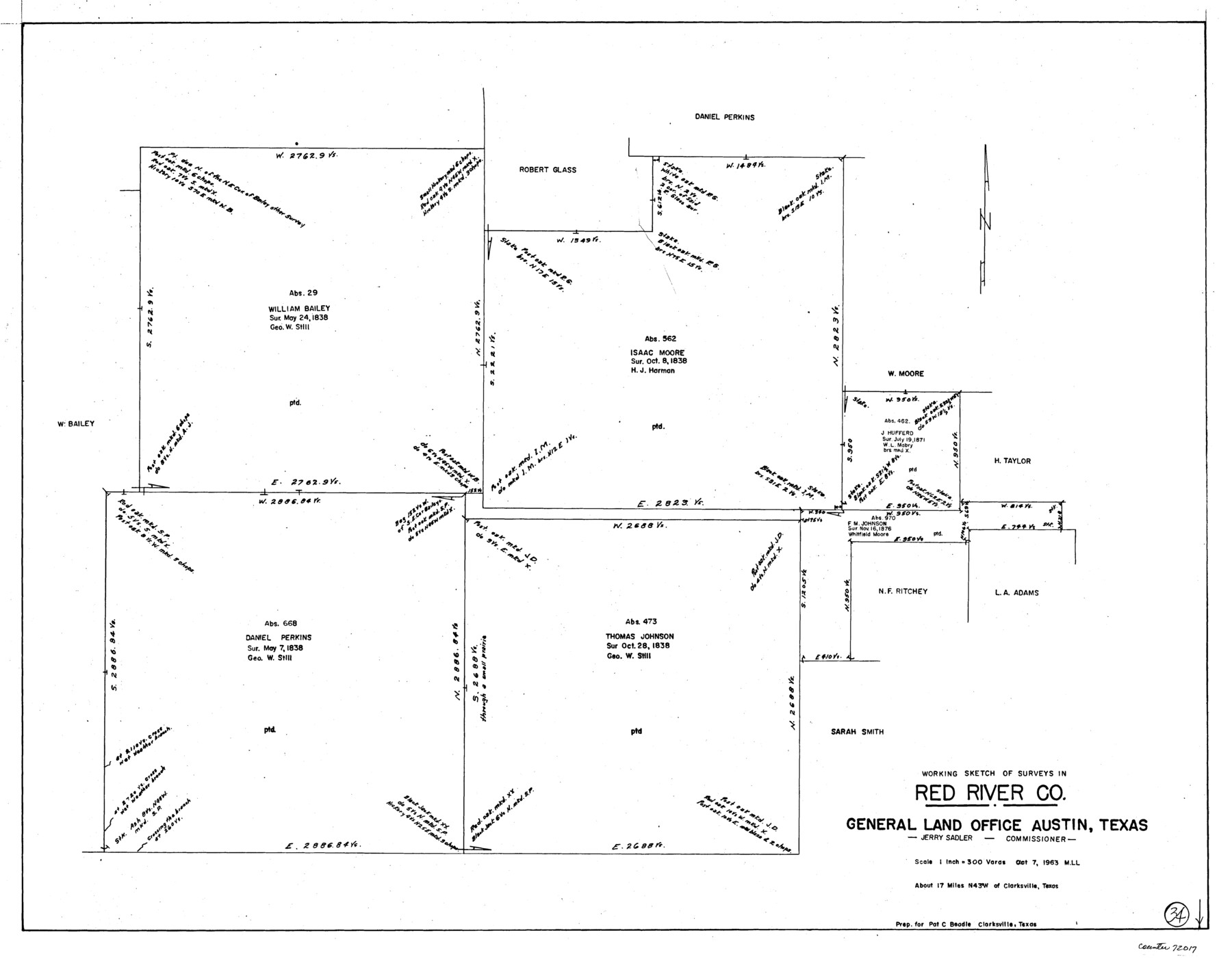
Red River County Working Sketch 34
-
Map/Doc
72017
-
Collection
General Map Collection
-
Object Dates
10/7/1963 (Creation Date)
-
People and Organizations
M. L. Liles (Draftsman)
-
Counties
Red River
-
Subjects
Surveying Working Sketch
-
Height x Width
25.8 x 33.1 inches
65.5 x 84.1 cm
-
Scale
1" = 300 varas
Part of: General Map Collection
Hardin County Sketch File 6

Print $4.00
- Digital $50.00
Hardin County Sketch File 6
Size 8.0 x 12.7 inches
Map/Doc 25097
United States

Print $40.00
- Digital $50.00
United States
1961
Size 55.0 x 81.2 inches
Map/Doc 75922
Brewster County Rolled Sketch 114

Print $20.00
- Digital $50.00
Brewster County Rolled Sketch 114
1964
Size 12.0 x 18.4 inches
Map/Doc 5278
El Paso County Boundary File 4b

Print $24.00
- Digital $50.00
El Paso County Boundary File 4b
Size 12.3 x 9.0 inches
Map/Doc 53066
Aransas County Sketch File 37

Print $139.00
- Digital $50.00
Aransas County Sketch File 37
1995
Size 11.1 x 9.1 inches
Map/Doc 13413
Flight Mission No. BRA-8M, Frame 130, Jefferson County

Print $20.00
- Digital $50.00
Flight Mission No. BRA-8M, Frame 130, Jefferson County
1953
Size 15.8 x 15.7 inches
Map/Doc 85626
Navarro County Working Sketch 13

Print $20.00
- Digital $50.00
Navarro County Working Sketch 13
1980
Size 15.6 x 16.1 inches
Map/Doc 71243
Denton County Working Sketch 32

Print $20.00
- Digital $50.00
Denton County Working Sketch 32
Size 35.1 x 32.0 inches
Map/Doc 68637
Map of the United States constructed from the latest authorities

Print $20.00
- Digital $50.00
Map of the United States constructed from the latest authorities
1825
Size 19.4 x 24.5 inches
Map/Doc 93924
Refugio County NRC Article 33.136 Location Key Sheet

Print $20.00
- Digital $50.00
Refugio County NRC Article 33.136 Location Key Sheet
Size 26.3 x 22.3 inches
Map/Doc 87912
Flight Mission No. DQO-3K, Frame 36, Galveston County

Print $20.00
- Digital $50.00
Flight Mission No. DQO-3K, Frame 36, Galveston County
1952
Size 18.7 x 22.4 inches
Map/Doc 85077
Harris County Sketch File 14

Print $20.00
- Digital $50.00
Harris County Sketch File 14
Size 17.4 x 18.4 inches
Map/Doc 11649
You may also like
Reagan County Working Sketch 27

Print $20.00
- Digital $50.00
Reagan County Working Sketch 27
1960
Size 33.0 x 42.5 inches
Map/Doc 71869
Sketch T [showing Capitol Reserve]
![89631, Sketch T [showing Capitol Reserve], Twichell Survey Records](https://historictexasmaps.com/wmedia_w700/maps/89631-1.tif.jpg)
Print $40.00
- Digital $50.00
Sketch T [showing Capitol Reserve]
1903
Size 22.0 x 48.9 inches
Map/Doc 89631
Dallas County Working Sketch 13

Print $20.00
- Digital $50.00
Dallas County Working Sketch 13
1984
Size 27.9 x 32.6 inches
Map/Doc 68579
[Surveys in Austin's Colony along Chocolate Bayou and Austin Bayou]
![192, [Surveys in Austin's Colony along Chocolate Bayou and Austin Bayou], General Map Collection](https://historictexasmaps.com/wmedia_w700/maps/192.tif.jpg)
Print $20.00
- Digital $50.00
[Surveys in Austin's Colony along Chocolate Bayou and Austin Bayou]
1830
Size 32.9 x 10.8 inches
Map/Doc 192
Dimmit County Sketch File 49

Print $20.00
- Digital $50.00
Dimmit County Sketch File 49
1909
Size 17.3 x 26.8 inches
Map/Doc 11358
Andrews County Sketch File 17

Print $8.00
- Digital $50.00
Andrews County Sketch File 17
Size 11.1 x 8.6 inches
Map/Doc 12901
Matagorda County

Print $40.00
- Digital $50.00
Matagorda County
1920
Size 40.6 x 48.6 inches
Map/Doc 73232
Map of Nueces County

Print $20.00
- Digital $50.00
Map of Nueces County
1875
Size 24.6 x 37.4 inches
Map/Doc 3919
Kimble County Working Sketch 47

Print $20.00
- Digital $50.00
Kimble County Working Sketch 47
1951
Size 42.9 x 24.3 inches
Map/Doc 70115
Current Miscellaneous File 102

Print $611.00
- Digital $50.00
Current Miscellaneous File 102
Size 11.5 x 7.1 inches
Map/Doc 74379
Young County Working Sketch 7

Print $20.00
- Digital $50.00
Young County Working Sketch 7
1919
Size 24.3 x 19.8 inches
Map/Doc 62030
Deaf Smith County

Print $40.00
- Digital $50.00
Deaf Smith County
1922
Size 55.0 x 43.9 inches
Map/Doc 89768