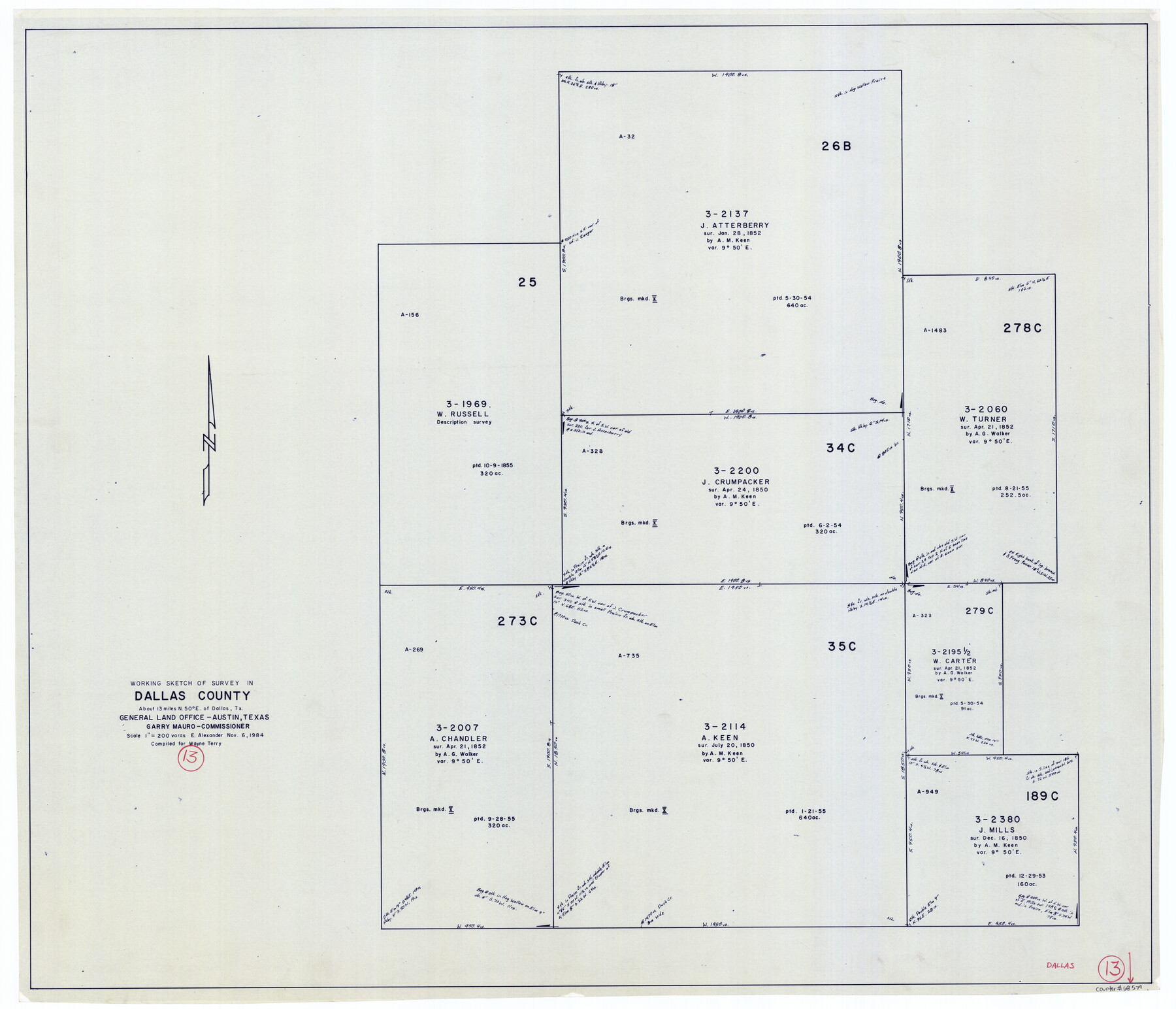
Dallas County Working Sketch 13
-
Map/Doc
68579
-
Collection
General Map Collection
-
Object Dates
11/6/1984 (Creation Date)
-
People and Organizations
Earl Alexander (Draftsman)
-
Counties
Dallas
-
Subjects
Surveying Working Sketch
-
Height x Width
27.9 x 32.6 inches
70.9 x 82.8 cm
-
Scale
1" = 200 varas
Part of: General Map Collection
Winkler County Sketch File 16

Print $30.00
- Digital $50.00
Winkler County Sketch File 16
1929
Size 14.2 x 8.7 inches
Map/Doc 40493
Cherokee County Working Sketch 2

Print $20.00
- Digital $50.00
Cherokee County Working Sketch 2
1932
Size 40.8 x 35.9 inches
Map/Doc 67957
Map of Jefferson County

Print $20.00
- Digital $50.00
Map of Jefferson County
1840
Size 34.8 x 27.0 inches
Map/Doc 3726
Brazoria County Sketch File 29

Print $8.00
- Digital $50.00
Brazoria County Sketch File 29
1889
Size 14.0 x 8.8 inches
Map/Doc 15033
Map of Mason County

Print $20.00
- Digital $50.00
Map of Mason County
1879
Size 22.5 x 18.8 inches
Map/Doc 3839
Motley County Sketch File 9a (N)

Print $4.00
- Digital $50.00
Motley County Sketch File 9a (N)
1885
Size 14.2 x 8.6 inches
Map/Doc 32024
Map of section no. 3 of a survey of Padre Island made for the Office of the Attorney General of the State of Texas

Print $40.00
- Digital $50.00
Map of section no. 3 of a survey of Padre Island made for the Office of the Attorney General of the State of Texas
1941
Size 49.6 x 40.2 inches
Map/Doc 2259

Blanco County Rolled Sketch 22

Print $20.00
- Digital $50.00
Blanco County Rolled Sketch 22
2007
Size 17.4 x 11.4 inches
Map/Doc 87926
Wise County Sketch File 5

Print $6.00
- Digital $50.00
Wise County Sketch File 5
1856
Size 8.2 x 14.0 inches
Map/Doc 40531
Rains County Sketch File 7

Print $4.00
- Digital $50.00
Rains County Sketch File 7
Size 6.2 x 7.9 inches
Map/Doc 34956
Baylor County Aerial Photograph Index Sheet 3

Print $20.00
- Digital $50.00
Baylor County Aerial Photograph Index Sheet 3
1950
Size 20.4 x 15.5 inches
Map/Doc 83665
You may also like
The Chief Justice County of Nacogdoches. Lands in Conflict with Red River and Washington Counties

Print $20.00
The Chief Justice County of Nacogdoches. Lands in Conflict with Red River and Washington Counties
2020
Size 17.6 x 21.7 inches
Map/Doc 96064
Flight Mission No. BQR-22K, Frame 35, Brazoria County

Print $20.00
- Digital $50.00
Flight Mission No. BQR-22K, Frame 35, Brazoria County
1953
Size 18.7 x 22.5 inches
Map/Doc 84119
Concho County

Print $20.00
- Digital $50.00
Concho County
1947
Size 46.8 x 36.9 inches
Map/Doc 73115
Railroad Track Map, T&PRRCo., Culberson County, Texas

Print $4.00
- Digital $50.00
Railroad Track Map, T&PRRCo., Culberson County, Texas
1910
Size 11.8 x 18.6 inches
Map/Doc 62828
Van Zandt County Sketch File 31

Print $4.00
- Digital $50.00
Van Zandt County Sketch File 31
1860
Size 12.6 x 8.1 inches
Map/Doc 39463
Palo Pinto County Rolled Sketch 4

Print $20.00
- Digital $50.00
Palo Pinto County Rolled Sketch 4
Size 15.9 x 23.2 inches
Map/Doc 7189
Morris County Rolled Sketch 2

Print $40.00
- Digital $50.00
Morris County Rolled Sketch 2
1944
Size 59.4 x 43.5 inches
Map/Doc 9550
Map of Presidio County

Print $40.00
- Digital $50.00
Map of Presidio County
1895
Size 53.0 x 38.6 inches
Map/Doc 3968
Titus County Working Sketch Graphic Index

Print $20.00
- Digital $50.00
Titus County Working Sketch Graphic Index
1948
Size 40.2 x 29.0 inches
Map/Doc 76714
[Leagues 7, 8, 9, and 10]
![92253, [Leagues 7, 8, 9, and 10], Twichell Survey Records](https://historictexasmaps.com/wmedia_w700/maps/92253-1.tif.jpg)
Print $20.00
- Digital $50.00
[Leagues 7, 8, 9, and 10]
Size 31.7 x 24.4 inches
Map/Doc 92253
Terrell County Rolled Sketch 9

Print $20.00
- Digital $50.00
Terrell County Rolled Sketch 9
Size 17.6 x 42.9 inches
Map/Doc 7925
Flight Mission No. CUG-1P, Frame 22, Kleberg County

Print $20.00
- Digital $50.00
Flight Mission No. CUG-1P, Frame 22, Kleberg County
1956
Size 18.7 x 22.1 inches
Map/Doc 86112