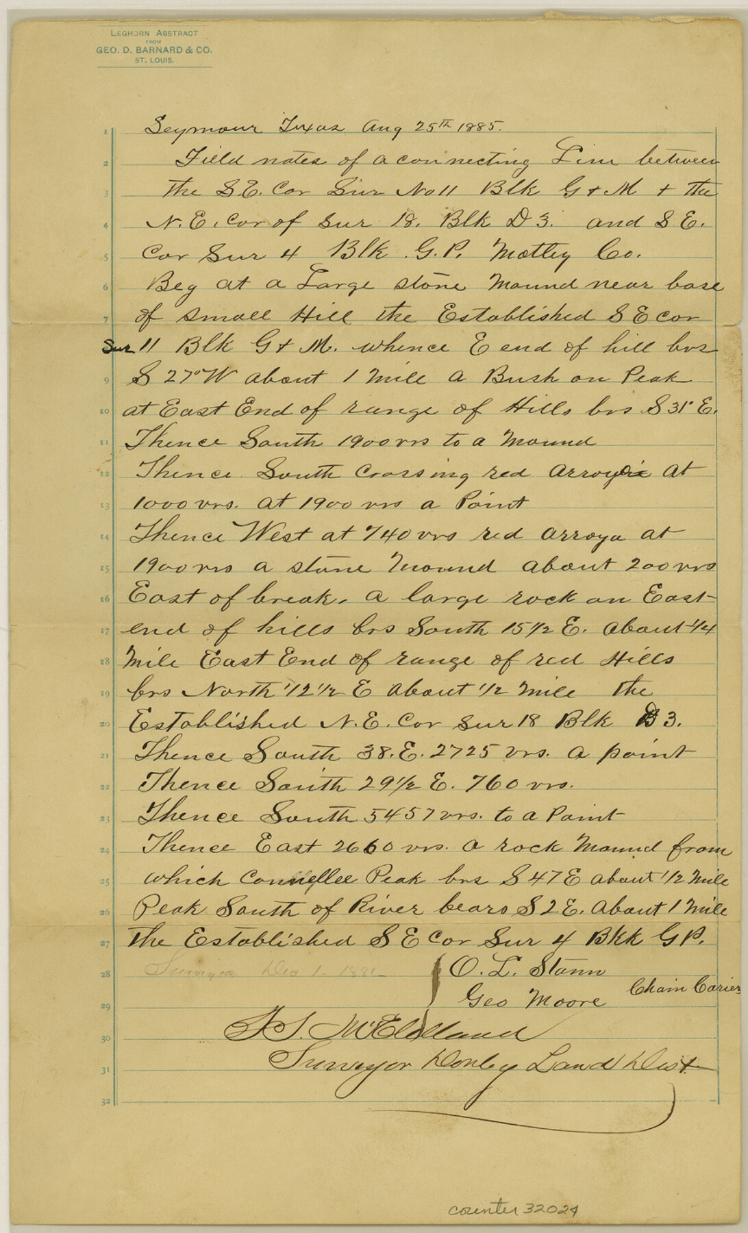
Motley County Sketch File 9a (N)
[Field notes of a connecting line between the southeast corner survey number 11, Block G. & M and the northeast corner of survey 18, Block D3 and southeast corner of survey 4, Block G. P.]
-
Map/Doc
32024
-
Collection
General Map Collection
-
Object Dates
8/25/1885 (Creation Date)
10/6/1885 (File Date)
8/25/1885 (Correspondence Date)
-
People and Organizations
T.S. McClelland (Surveyor/Engineer)
O.L. Stann (Chainman/Field Personnel)
George Moore (Chainman/Field Personnel)
-
Counties
Motley
-
Subjects
Surveying Sketch File
-
Height x Width
14.2 x 8.6 inches
36.1 x 21.8 cm
-
Medium
paper, manuscript
-
Features
Red Arroyo
Part of: General Map Collection
Flight Mission No. BRA-6M, Frame 84, Jefferson County

Print $20.00
- Digital $50.00
Flight Mission No. BRA-6M, Frame 84, Jefferson County
1953
Size 18.6 x 22.4 inches
Map/Doc 85428
[Surveys East of river copied from U.S. map of Township No. 6 South, Range No. 9 West of the Indian Meridian, Oklahoma]
![75185, [Surveys East of river copied from U.S. map of Township No. 6 South, Range No. 9 West of the Indian Meridian, Oklahoma], General Map Collection](https://historictexasmaps.com/wmedia_w700/maps/75185.tif.jpg)
Print $2.00
- Digital $50.00
[Surveys East of river copied from U.S. map of Township No. 6 South, Range No. 9 West of the Indian Meridian, Oklahoma]
Size 13.3 x 9.0 inches
Map/Doc 75185
[Gulf Colorado & Santa Fe from 2178+36.0 to 3901+06.2]
![64696, [Gulf Colorado & Santa Fe from 2178+36.0 to 3901+06.2], General Map Collection](https://historictexasmaps.com/wmedia_w700/maps/64696-1.tif.jpg)
Print $40.00
- Digital $50.00
[Gulf Colorado & Santa Fe from 2178+36.0 to 3901+06.2]
Size 32.0 x 120.5 inches
Map/Doc 64696
Cass County Rolled Sketch 5A

Print $20.00
- Digital $50.00
Cass County Rolled Sketch 5A
Size 15.4 x 18.0 inches
Map/Doc 5411
Amistad International Reservoir on Rio Grande 61

Print $20.00
- Digital $50.00
Amistad International Reservoir on Rio Grande 61
1949
Size 28.4 x 39.4 inches
Map/Doc 73346
Dickens County Sketch File H2

Print $2.00
- Digital $50.00
Dickens County Sketch File H2
Size 12.9 x 8.2 inches
Map/Doc 20874
Nueces County Rolled Sketch 36

Print $199.00
- Digital $50.00
Nueces County Rolled Sketch 36
Size 10.7 x 15.2 inches
Map/Doc 47617
Brewster County Sketch File N-3a

Print $40.00
- Digital $50.00
Brewster County Sketch File N-3a
Size 14.5 x 18.9 inches
Map/Doc 10962
Williamson County Sketch File 20

Print $4.00
- Digital $50.00
Williamson County Sketch File 20
Size 8.2 x 12.9 inches
Map/Doc 40348
Flight Mission No. CLL-1N, Frame 103, Willacy County

Print $20.00
- Digital $50.00
Flight Mission No. CLL-1N, Frame 103, Willacy County
1954
Size 18.4 x 22.1 inches
Map/Doc 87037
Dickens County Sketch File 29

Print $6.00
- Digital $50.00
Dickens County Sketch File 29
1921
Size 5.9 x 8.8 inches
Map/Doc 21016
Webb County Sketch File 4-2

Print $20.00
- Digital $50.00
Webb County Sketch File 4-2
1925
Size 26.3 x 18.1 inches
Map/Doc 12615
You may also like
Dawson County Rolled Sketch 7

Print $20.00
- Digital $50.00
Dawson County Rolled Sketch 7
Size 18.5 x 39.3 inches
Map/Doc 5692
Flight Mission No. CRC-4R, Frame 67, Chambers County

Print $20.00
- Digital $50.00
Flight Mission No. CRC-4R, Frame 67, Chambers County
1956
Size 18.8 x 22.5 inches
Map/Doc 84871
Ellis County Sketch File 2

Print $11.00
- Digital $50.00
Ellis County Sketch File 2
1858
Size 8.4 x 9.7 inches
Map/Doc 21827
VanZandt County Showing the Located Route of the Texas and Pacific R.R.

Print $20.00
- Digital $50.00
VanZandt County Showing the Located Route of the Texas and Pacific R.R.
1872
Size 24.5 x 22.3 inches
Map/Doc 64136
Flight Mission No. CLL-1N, Frame 32, Willacy County

Print $20.00
- Digital $50.00
Flight Mission No. CLL-1N, Frame 32, Willacy County
1954
Size 17.5 x 19.4 inches
Map/Doc 87013
El Paso County Rolled Sketch 50

Print $20.00
- Digital $50.00
El Paso County Rolled Sketch 50
1956
Size 18.9 x 26.7 inches
Map/Doc 5835
Map of San Leon, Amos Edwards League, Galveston County, Texas

Print $20.00
- Digital $50.00
Map of San Leon, Amos Edwards League, Galveston County, Texas
1911
Size 22.9 x 14.1 inches
Map/Doc 3037
Terrell County Rolled Sketch H

Print $20.00
- Digital $50.00
Terrell County Rolled Sketch H
Size 17.2 x 22.9 inches
Map/Doc 7977
Howard County Working Sketch Graphic Index

Print $20.00
- Digital $50.00
Howard County Working Sketch Graphic Index
1922
Size 42.5 x 36.3 inches
Map/Doc 76583
Runnels County Sketch File 14

Print $20.00
Runnels County Sketch File 14
1884
Size 16.3 x 20.4 inches
Map/Doc 12252

Bastrop County Sketch File 6

Print $4.00
- Digital $50.00
Bastrop County Sketch File 6
1875
Size 8.8 x 7.8 inches
Map/Doc 14050