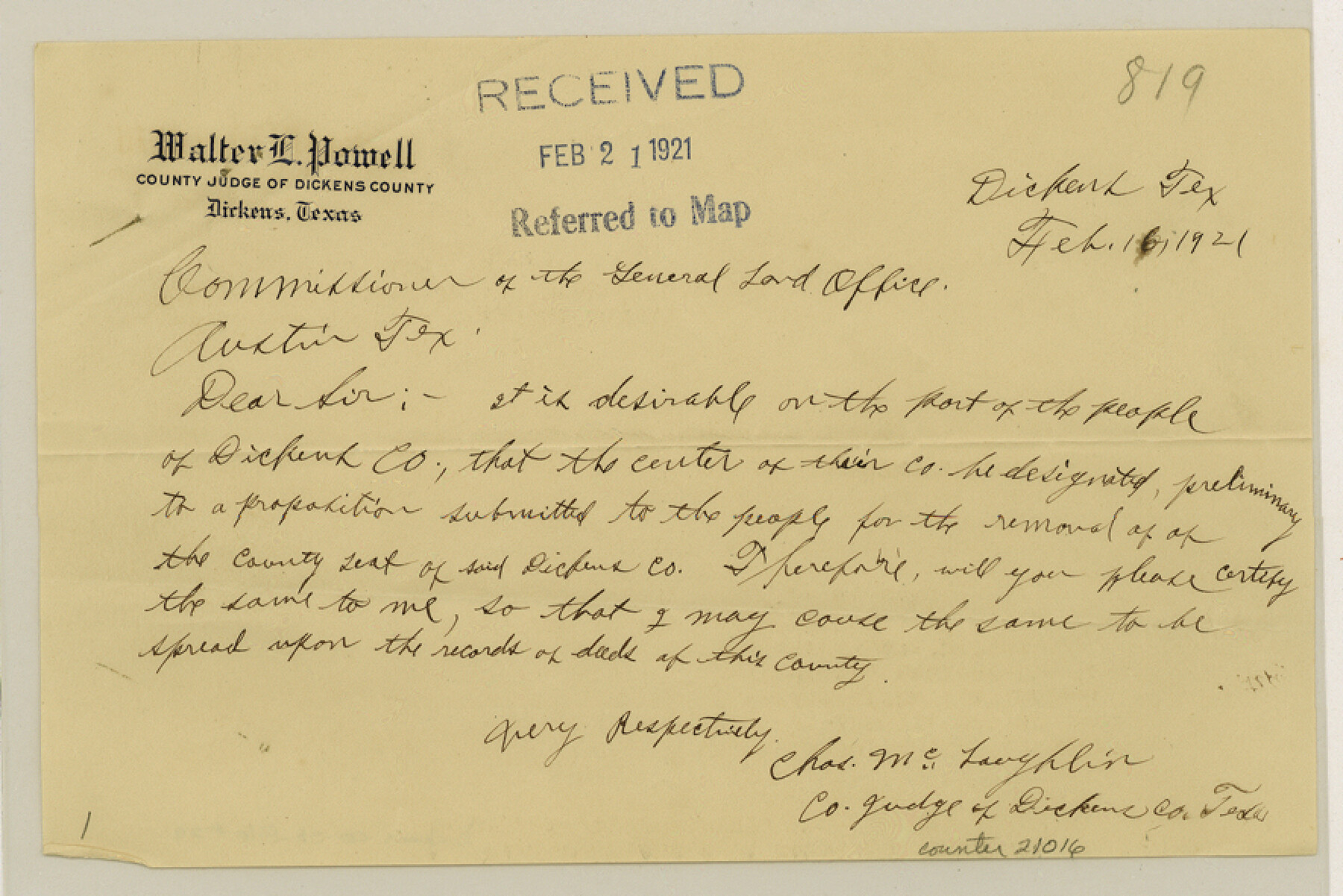
Dickens County Sketch File 29
[Copy of certificate designating geographical center of Dickens County]
-
Map/Doc
21016
-
Collection
General Map Collection
-
Object Dates
1921/2/28 (Creation Date)
-
People and Organizations
J.T. Robison (GLO Commissioner)
-
Counties
Dickens
-
Subjects
Surveying Sketch File
-
Height x Width
5.9 x 8.8 inches
15.0 x 22.4 cm
-
Medium
paper, print
Part of: General Map Collection
Calhoun County Rolled Sketch 15

Print $20.00
- Digital $50.00
Calhoun County Rolled Sketch 15
Size 34.4 x 42.6 inches
Map/Doc 8548
Guadalupe County

Print $20.00
- Digital $50.00
Guadalupe County
1877
Size 21.5 x 21.4 inches
Map/Doc 3608
Anderson County Boundary File 3

Print $9.00
- Digital $50.00
Anderson County Boundary File 3
Size 14.3 x 8.8 inches
Map/Doc 49733
Dickens County

Print $20.00
- Digital $50.00
Dickens County
1895
Size 22.8 x 18.7 inches
Map/Doc 3484
Sutton County

Print $40.00
- Digital $50.00
Sutton County
1898
Size 41.1 x 58.3 inches
Map/Doc 78392
Jones County Sketch File 5

Print $4.00
- Digital $50.00
Jones County Sketch File 5
1859
Size 10.0 x 8.1 inches
Map/Doc 28492
Edwards County Working Sketch 62

Print $20.00
- Digital $50.00
Edwards County Working Sketch 62
1955
Size 21.7 x 28.5 inches
Map/Doc 68938
Clay County Rolled Sketch 2

Print $20.00
- Digital $50.00
Clay County Rolled Sketch 2
1940
Size 35.9 x 26.8 inches
Map/Doc 5485
Culberson County Working Sketch 90

Print $20.00
- Digital $50.00
Culberson County Working Sketch 90
1992
Size 35.0 x 28.0 inches
Map/Doc 68544
Llano County Sketch File 16

Print $12.00
- Digital $50.00
Llano County Sketch File 16
1905
Size 12.3 x 11.3 inches
Map/Doc 30392
Motley County Sketch File 20 (N)

Print $6.00
- Digital $50.00
Motley County Sketch File 20 (N)
1943
Size 11.3 x 8.8 inches
Map/Doc 32066
Terrell County Sketch File 35

Print $36.00
- Digital $50.00
Terrell County Sketch File 35
1957
Size 32.0 x 37.6 inches
Map/Doc 10389
You may also like
General Highway Map, Knox County, Texas

Print $20.00
General Highway Map, Knox County, Texas
1940
Size 18.3 x 24.8 inches
Map/Doc 79166
Map of Surveys Made for the T&PRR in Borden, Howard & Mitchell Counties, Blocks 27, 28, 29, 30 & 31, Reserve West of the Colorado

Print $20.00
- Digital $50.00
Map of Surveys Made for the T&PRR in Borden, Howard & Mitchell Counties, Blocks 27, 28, 29, 30 & 31, Reserve West of the Colorado
1876
Size 42.8 x 39.7 inches
Map/Doc 2230
Reeves County Rolled Sketch 35

Print $20.00
- Digital $50.00
Reeves County Rolled Sketch 35
2013
Size 25.3 x 36.8 inches
Map/Doc 93706
General Highway Map, Bailey County, Texas

Print $20.00
General Highway Map, Bailey County, Texas
1961
Size 25.0 x 18.2 inches
Map/Doc 79359
Lynn County Boundary File 1

Print $10.00
- Digital $50.00
Lynn County Boundary File 1
Size 14.2 x 8.7 inches
Map/Doc 56617
[Township 3 North, Blocks 33 and 34, T. & P. RR. Company; Township 4 North, Block 33, T. & P. RR. Company]
![92564, [Township 3 North, Blocks 33 and 34, T. & P. RR. Company; Township 4 North, Block 33, T. & P. RR. Company], Twichell Survey Records](https://historictexasmaps.com/wmedia_w700/maps/92564-1.tif.jpg)
Print $20.00
- Digital $50.00
[Township 3 North, Blocks 33 and 34, T. & P. RR. Company; Township 4 North, Block 33, T. & P. RR. Company]
1911
Size 18.6 x 24.8 inches
Map/Doc 92564
Fort Bend County State Real Property Sketch 11

Print $40.00
- Digital $50.00
Fort Bend County State Real Property Sketch 11
1986
Size 34.6 x 43.2 inches
Map/Doc 61685
Flight Mission No. CGI-3N, Frame 48, Cameron County

Print $20.00
- Digital $50.00
Flight Mission No. CGI-3N, Frame 48, Cameron County
1954
Size 18.7 x 22.2 inches
Map/Doc 84554
[Texas & Pacific Railway through Callahan County]
![64238, [Texas & Pacific Railway through Callahan County], General Map Collection](https://historictexasmaps.com/wmedia_w700/maps/64238.tif.jpg)
Print $20.00
- Digital $50.00
[Texas & Pacific Railway through Callahan County]
1918
Size 22.4 x 9.4 inches
Map/Doc 64238
Map of Kimble County

Print $20.00
- Digital $50.00
Map of Kimble County
1878
Size 19.7 x 29.0 inches
Map/Doc 3766
[Sketch for Mineral Application 20124, North Fork of Red River]
![2828, [Sketch for Mineral Application 20124, North Fork of Red River], General Map Collection](https://historictexasmaps.com/wmedia_w700/maps/2828.tif.jpg)
Print $20.00
- Digital $50.00
[Sketch for Mineral Application 20124, North Fork of Red River]
1943
Size 18.8 x 25.8 inches
Map/Doc 2828
Andrews County Rolled Sketch 46

Print $40.00
- Digital $50.00
Andrews County Rolled Sketch 46
2013
Size 52.0 x 36.0 inches
Map/Doc 93641